![]()

Chichen Itza
Chichen Itza - Tinum, Mexico
Chichén Itzá is a sprawling pre-Columbian city built by the Maya people beginning in the Late Classic period, located in the Tinúm Municipality of Yucatán state, Mexico, on the Yucatán Peninsula. Covering an area of approximately 6.5 square kilometers with densely clustered architecture, it served as a major regional capital and pilgrimage site, featuring monumental stone structures that blend indigenous Maya construction techniques with Toltec influences from central Mexico. Designated a UNESCO World Heritage Site in 1988 under criteria (i), (ii), and (iii) for its outstanding testimony to the Maya-Toltec civilization, the site exemplifies advanced astronomical knowledge and artistic expression through its pyramids, temples, ball courts, and observatories.
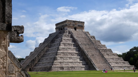
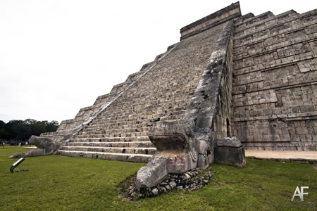
The city's origins trace back to the Classic period around the 6th century CE, when it was established near natural cenotes—sinkholes that provided vital water sources in the karst landscape and held sacred significance for rituals, including human sacrifices evidenced by archaeological finds of jade, gold artifacts, and human remains in the Sacred Cenote. It rose to prominence around 800 A.D., flourishing as a powerful political and religious center until about 1050 A.D., with a population sustained by agriculture, trade, and alliances that incorporated Toltec influences in the late 10th century under the leadership figure Kukulkan (Quetzalcoatl). Recent 2024 DNA analysis confirms genetic links to modern locals and details on ritual sacrifices, including of twins, during the site's peak. This era saw the construction of iconic structures like El Castillo (the Pyramid of Kukulkan), a 30-meter-tall stepped pyramid with 365 steps symbolizing the solar year, where equinox sunlight creates a descending serpent shadow along its balustrades.
Other notable features include the Great Ball Court, the largest in Mesoamerica at 168 meters long, used for ritual pok-a-tok games tied to cosmology and warfare; the Temple of the Warriors, adorned with chacmool altars for offerings; and El Caracol, a circular observatory aligned for tracking Venus, Mars, and solar zenith passages critical to Maya calendars and agriculture. The site declined after 1200 A.D. due to environmental pressures, internal conflicts, and shifting regional powers, though it remained a pilgrimage destination into the Spanish colonial period. Today, managed by Mexico's National Institute of Anthropology and History (INAH), Chichén Itzá attracts over 2.5 million visitors annually as of 2024, with daily peaks exceeding 10,000 (as of 2025) and a new reservation system limiting concurrent visitors to 5,000 to combat overtourism, facing challenges like erosion while preserving its role as a key vestige of Maya-Toltec cultural fusion.
Nomenclature and Location
Etymology and Orthography
 The name "Chichen Itza" derives from the Yucatec Maya language, specifically from the phrase Chi'ch'en Ïitza', which translates to "at the mouth of the well of the Itza." This etymology references the site's prominent sacred cenotes, natural sinkholes considered gateways to the underworld and vital water sources, while "Itza" denotes the ruling clan or ethnic group associated with the site. The term chi' signifies "mouth" or "edge," ch'e'en or ch'en means "well," and Ïitza' points to the Itza people, underscoring the location's significance in Maya cosmology and hydrology.
Orthographic variations of the name have evolved across historical and linguistic contexts, influenced by colonial and modern standardization efforts. In 19th-century English accounts, such as John Lloyd Stephens' 1843 travelogue Incidents of Travel in Yucatan, the spelling appears as "Chichen Itza" without accents or hyphens, reflecting phonetic approximations by European explorers unfamiliar with Maya diacritics. Spanish colonial records and later adaptations introduced accents and modifications, leading to the contemporary form "Chichén Itzá," which preserves stress on both syllables and aligns with Spanish orthography. The Yucatec Maya orthography, Chich'en Itza', incorporates glottal stops and apostrophes to denote phonetic nuances absent in anglicized or hispanized versions.
Alternative interpretations of the name highlight Toltec-Maya syncretism, particularly linking "Itza" to Itzamna, the Maya creator god revered as the inventor of writing, divination, and the heavens. In this context, the Itza clan is mythologically tied to Itzamna's lineage, portraying them as "water sorcerers" or descendants of the deity who founded the city around the sacred wells. This association blends indigenous Maya beliefs with post-classic influences from central Mexico, where Toltec elements appear in the site's architecture and iconography, though the core nomenclature remains rooted in Yucatec Maya traditions.
Geographical Setting
Chichén Itzá is situated at coordinates 20°40′58″N 88°34′7″W in the Tinúm Municipality of Yucatán state, Mexico, along Federal Highway 180 approximately 120 km east of Mérida and 200 km west of Cancún. This positioning places it in the heart of the Yucatán Peninsula, a region marked by flat limestone plains that rise modestly between 20 and 40 meters above sea level.
The site's environment is defined by a karst landscape of porous limestone bedrock, which prevents the formation of surface rivers and instead channels water underground through an extensive network of aquifers. As a result, the ancient Maya relied heavily on natural sinkholes known as cenotes for freshwater, with two prominent cenotes directly associated with Chichén Itzá serving as vital resources. The surrounding vegetation consists of tropical deciduous forest, featuring species such as ramón (Brosimum alicastrum), chechén (Metopium brownei), and zapote (Manilkara zapota), adapted to the tropical climate with average temperatures around 26°C and annual rainfall of about 1,200 mm.
Within the broader regional context, Chichén Itzá lies in the Northern Maya Lowlands, a cultural and ecological zone extending across northern Yucatán and into Quintana Roo. Its proximity to other major sites, including Uxmal to the southwest and Ek Balam to the northeast, enhanced its role as a hub along key trade routes connecting the peninsula's interior to coastal ports and distant regions like central Mexico. This strategic placement facilitated the exchange of goods such as obsidian, jade, and feathers, underscoring the site's economic significance in the Maya world.
Historical Development
Origins and Establishment
 Chichen Itza's initial settlement occurred during the Late Classic period, with archaeological evidence indicating human occupation beginning around 600–650 CE, based on the earliest appearances of the Yabnal-Motul ceramic complex in construction fills and ritual deposits. Though ethnohistoric accounts suggest legendary origins around 415–455 CE, this complex, characterized by Say Slate Group vessels and imported wares such as Tres Marías Striated Type from Quintana Roo and Belize, suggests early external connections that supported a growing community south of the Sacred Cenote. By 750–900 CE, during the transition to the Terminal Classic, settlement intensified, marked by the construction of terraces like the Terrace of the Three Lintels (dated 650–750 CE) and cist burials containing jade artifacts and ceramics from the Petén region, reflecting a shift toward more organized habitation.
Key evidence for this foundational phase includes ceramic assemblages and monumental inscriptions that highlight the site's emergence as a regional center. The Huuntun-Cehpech ceramic complex (800–1000 CE), featuring Puuc Slate Ware, dominates Terminal Classic deposits and is associated with early structures like the House of the Phalli (ca. 830 CE) and the Temple of the Wall Panels (Structure 3C16), indicating a population capable of large-scale building projects. Stelae provide further chronological markers, such as Stela 2 (dated 869–909 CE), which records hieroglyphic events tied to local rulers, while the Akab Dzib structure, a Puuc-style building with geometric facades and dated to around 869 CE, exemplifies the architectural transition from Classic Maya influences through vaulted masonry and colonnettes. These artifacts, including over 2,300 Yabnal-Motul sherds from the Sacred Cenote (3.7% of the total collection), underscore ritual continuity and economic ties that facilitated settlement growth.
The cultural foundations of Chichen Itza were laid by Itza Maya groups, who established the site amid broader shifts in northern Yucatán society during the Late to Terminal Classic periods. These groups, likely Yucatec-speaking Maya with roots in the region, incorporated Puuc-style elements—such as intricate stone veneers and Chaac masks—suggesting an influx of influences from nearby Puuc sites in western Yucatán, rather than direct migration from distant southern lowlands. Imported ceramics from the Petén and coastal areas indicate possible population movements or trade networks that marked a departure from the hierarchical theocratic city-states of the southern Maya lowlands, fostering a more decentralized community structure by 900 CE. This establishment phase positioned Chichen Itza as a hub for ritual and agrarian activities, with early architecture like the Akab Dzib reflecting adaptive Maya traditions.
Ascendancy and Peak
Chichen Itza reached its zenith during the Early Postclassic period, flourishing from approximately 900 to 1200 CE, when it emerged as a dominant regional power in the northern Maya lowlands. This era marked a significant transformation following the Terminal Classic collapse, characterized by a fusion of local Maya traditions with influences from central Mexico, particularly the Toltecs. Ethnohistoric accounts, such as those recorded in colonial-era documents, describe the arrival of a leader named Kukulcan—equivalent to the Nahuatl Quetzalcoatl—around 987 CE, who is said to have led a group of warriors from the west, establishing a militaristic regime that reshaped the site's governance and ideology. This influx introduced elements of conquest and warrior cults, evident in inscriptions depicting figures in Toltec attire and the adoption of Nahuatl terms like "macehual" for commoners, signaling a period of centralized, aggressive rule.
Key architectural and cultural developments during this phase underscored Chichen Itza's ascendance, including the construction of monumental structures that blended Maya and Toltec styles. The Pyramid of Kukulcan, known as El Castillo, was erected around 1000 CE as a central temple dedicated to the feathered serpent deity, symbolizing the site's embrace of the Kukulcan/Quetzalcoatl cult imported from central Mexico. Similarly, the Great Ball Court, the largest of its kind in Mesoamerica and dated to the late Postclassic around 1142 CE, facilitated ritual ball games that reinforced social hierarchies and militaristic themes. These projects reflected a deliberate fusion of architectural motifs, such as colonnaded halls and serpent imagery, which propagated the feathered serpent worship as a unifying religious force across the region.
At its peak, Chichen Itza served as a bustling regional capital, sustaining a population estimated at around 50,000 inhabitants through expansive trade networks that imported goods like obsidian and feathers from distant areas. The site's cultural prominence was further highlighted by sophisticated astronomical alignments, notably in El Castillo, where during the spring and autumn equinoxes, the sun casts triangular shadows down the northern staircase, creating the illusion of a descending serpent that merges with carved serpent heads at the base—a deliberate design to embody the Kukulcan deity's earthly manifestation. This phenomenon, observable twice annually, underscored the elite's mastery of celestial knowledge and reinforced Chichen Itza's status as a sacred and political hub until the mid-12th century.
Decline and Abandonment
 The decline of Chichen Itza unfolded gradually during the Late Postclassic period, approximately 1200–1400 CE, marking the end of its dominance as a regional political and ceremonial center in the northern Yucatán Peninsula. Around 1221 CE, a major revolt and civil war among Maya factions led to the conquest of Chichen Itza by forces from the rival city-state of Mayapán, shifting political power to the latter and initiating a period of fragmentation within the broader Maya league of city-states. This transition reflected broader political instability, with Mayapán emerging as the new capital by the mid-13th century, though Chichen Itza retained some ceremonial significance as a pilgrimage site into the 15th century.
Several interconnected factors contributed to this downturn, including environmental stress, internal conflicts, and external rivalries. Speleothem records from caves in the Yucatán, such as those analyzed in multi-proxy paleoclimate studies, indicate prolonged droughts during the preceding centuries (ca. 1000–1100 CE) that likely exacerbated resource scarcity and sociopolitical tensions into the Late Postclassic, undermining agricultural productivity and elite authority at Chichen Itza. Internal strife, evidenced by archaeological signs of violence such as burned structures and defensive modifications, stemmed from factional revolts against the ruling Itzá elite, driven by resentment over tribute demands and resource overexploitation. External pressures intensified these issues, as rival city-states like Mayapán challenged Chichen Itza's hegemony through military alliances and territorial encroachments, leading to the erosion of its confederacy. This political fragmentation, characterized by shifting alliances among Yucatecan polities, further weakened centralized control.
A clear indicator of waning power was the sharp reduction in monumental construction after the early 12th century, with no major new buildings or inscribed stelae erected, signaling the cessation of elite-sponsored public works that had defined the site's earlier prosperity. Radiocarbon dating from lintels and excavation contexts confirms this halt, contrasting with the intensive building phases of the prior centuries and reflecting diminished resources and authority.
Archaeological evidence for abandonment includes shifts in ceramic assemblages toward Puuc revival styles, such as the reappearance of Terminal Classic forms like Cehpech and Sotuta types, which suggest cultural continuity and regional influences from earlier Puuc traditions amid the site's reduced role. Settlement surveys in the surrounding hinterlands reveal depopulation, with decreased residential density and fewer occupied sites by the 14th century, inferred from surface artifact scatters and architectural abandonment patterns that indicate a contraction from peak populations of 30,000–50,000 to sparse, ceremonial use.
Spanish Conquest and Rediscovery
 During the Spanish conquest of the Yucatán Peninsula, which extended from 1528 to 1542, Francisco de Montejo led expeditions that encountered strong resistance from Maya groups, including those at Chichen Itza. In 1533, Montejo's son, Francisco de Montejo the Younger, attempted to establish a settlement named Ciudad Real at the site, but local Maya forces laid siege to the outpost, killing or capturing over 150 Spaniards in acts that included ritual sacrifice, ultimately forcing the survivors to flee by night in 1535. These failed efforts exemplified the protracted Itza resistance, as the Maya employed defensive tactics such as palisades and ambushes to repel the invaders across the region.
Fray Diego de Landa, a Franciscan friar and bishop of Yucatán, documented aspects of this resistance in his 1566 account Relación de las cosas de Yucatán, describing the Itza as the dominant group at Chichen Itza under a powerful lord and noting their continued opposition to Spanish domination, including pilgrimages to the site's sacred cenote amid colonial pressures. Landa's writings, drawn from interrogations and observations, portrayed the Itza's cultural and political cohesion, which fueled their defiance during the conquest era.
Following the conquest's completion around 1546, Chichen Itza fell into obscurity, with the site—already largely abandoned as a major population center by the 1400s—repurposed as the Chichén Itzá hacienda starting from Montejo's initial 1527 incursion, involving limited agricultural use and sporadic looting of structures by locals and early colonists. Colonial records, such as the 1579 Relaciones Geográficas, mention the site's name but reflect minimal engagement, underscoring its transition from a contested stronghold to a peripheral colonial asset.
The site's rediscovery by Europeans occurred in 1843, when American explorer John Lloyd Stephens and English artist Frederick Catherwood visited the ruins during their Yucatán expedition, producing detailed descriptions and illustrations that captured the architectural grandeur of structures like El Castillo. Their work, published in Incidents of Travel in Yucatan, provided the first accurate visual and narrative documentation of the Maya ruins, igniting international scholarly and public fascination with pre-Columbian civilizations.
Modern Exploration and Research
In the early 20th century, the Carnegie Institution of Washington initiated systematic archaeological work at Chichen Itza, beginning in the 1920s under the direction of Sylvanus G. Morley. This project, which continued through the 1940s, focused on extensive mapping, excavation, and restoration of major structures, including the Temple of the Warriors and the Monjas complex, providing foundational documentation of the site's layout and chronology. Morley's efforts, supported by teams of architects and epigraphers, resulted in detailed surveys that clarified the site's architectural phases and Toltec-Maya influences, though the project concluded amid shifting institutional priorities by the mid-1950s.
Following the Carnegie era, the Mexican government, through the Instituto Nacional de Antropología e Historia (INAH), assumed responsibility for ongoing excavations and consolidations starting in the 1950s. INAH teams conducted restorations of key monuments, such as the Castillo pyramid and the Great Ball Court, emphasizing structural stabilization and integration into national heritage management. This period marked a transition to state-led research, with efforts yielding insights into postclassic ceramic sequences and ritual practices while prioritizing site preservation for public access.
Recent advancements have leveraged technologies like LiDAR surveys in the 2010s and 2020s to reveal previously hidden features across the site's protected zones, including over 1,000 kilometers (approximately 621 miles) of ancient causeways connecting Chichen Itza to broader Maya networks in the Yucatan Peninsula. These scans, achieving sub-centimeter accuracy, uncovered additional structures such as platforms and residential groups obscured by vegetation. In 2023, INAH archaeologists announced the discovery of a 1,100-year-old stone disk interpreted as a scoreboard for the Mesoamerican ball game, featuring carvings of players and dating to around 894 CE. That same year, excavations in the Chichen Viejo sector revealed an elite residential complex, including the Casa de los Caracoles (House of the Snails), House of the Moon, and Palace of the Phalluses, representing the first identified ruler's residence at the site. In 2024, genomic analysis of remains from the Sacred Cenote, published in Nature, revealed that the majority of the over 100 child sacrifices were boys, including two sets of identical twins, suggesting targeted ritual practices linked to the site's religious traditions during the Terminal Classic period. In February 2025, INAH announced the discovery of 'Castillo Viejo', a new zone within Chichén Itzá featuring previously unknown structures that provide further evidence of the site's Late Classic occupation and architectural evolution.
Societal and Economic Organization
Political Structure
During its peak in the Terminal Classic and Early Postclassic periods (ca. AD 800–1100), Chichen Itza's governance transitioned from the divine kingship characteristic of earlier Classic Maya polities to a more collective model influenced by Toltec cultural exchanges, though the extent and nature of this influence remain debated among scholars, with recent DNA evidence suggesting primarily local Maya populations rather than significant migration from central Mexico. This model featured a supreme leader known as the halach uinic ("true man" or ruler) who oversaw political and military affairs alongside a council of elites. This halach uinic held paramount authority, often identified with solar symbolism in iconography, but power was shared with a high priest as second-in-command and a political-military elite marked by serpent emblems, reflecting a multepal-style council rule that emphasized collaboration among ruling lineages rather than sole divine rule.
The social hierarchy placed an elite class of priests and warriors at the apex, who controlled rituals, warfare, and administration, supported by lower strata of artisans, merchants, and farmers who sustained the urban center through labor and tribute. Murals in structures like the Temple of the Wall Panels and Temple of the Warriors depict jaguar knights—elite warriors initiated by figures such as Serpent Jaguar—engaged in militaristic processions and transformations into divine birds, underscoring the intertwined roles of priesthood and military in governance and ideology. This organization promoted a warrior ethos, with elites undergoing ritual training and investiture to maintain hierarchy and social order.
Clan dynamics centered on the dominance of the Itza lineage, who named the site after themselves ("Mouth of the Well of the Itza") and formed the core ruling group, forging multi-ethnic alliances through Toltec-inspired integrations that bolstered political stability and expansion. Sacred kingship persisted in rituals like the ball game, where the halach uinic and elites participated to legitimize authority and resolve disputes among allied factions.
Economic Practices and Trade
The economy of Chichén Itzá relied heavily on agriculture adapted to the Yucatán Peninsula's karst landscape, where slash-and-burn milpa farming was the primary method. This system involved clearing forest plots through burning to cultivate a polyculture of maize (Zea mays), beans (Phaseolus spp.), and squash (Cucurbita spp.), known as the "three sisters" for their symbiotic growth, which optimized soil nutrients and crop yields. Archaeological evidence from paleoethnobotanical remains, including starch grains and phytoliths across Maya lowland sites, confirms these crops' centrality, with maize dominating caloric intake. To address seasonal droughts and thin soils, farmers employed terrace systems on slopes and drew irrigation water from cenotes, natural sinkholes that served as vital reservoirs in the water-scarce region. These practices supported population densities estimated at tens of thousands during the site's peak, though intensive features like terraces remain less documented at Chichén Itzá compared to southern lowlands.
Craft production at Chichén Itzá encompassed specialized workshops for utilitarian and prestige goods, evidenced by artifact distributions and production debris. Obsidian tool-making was prominent, with prismatic blades and cores sourced mainly from central Mexican quarries like Pachuca (48% of assemblages at linked sites) and worked locally, as indicated by manufacturing waste in residential and ceremonial contexts. Jade carving produced ornaments and beads from imported greenstone, often associated with elite burials, while pottery workshops generated vast quantities of local wares—such as Sotuta complex vessels (31% of Sacred Cenote sherds)—through coiling and firing techniques, inferred from the site's 2 million analyzed fragments showing 90% regional composition without foreign kilns. Chultuns, bell-shaped underground pits numbering over 100 at the site, stored surplus grains, tools, and possibly craft materials, linking production to household economies.
Long-distance trade networks bolstered Chichén Itzá's wealth, with the site exerting control over coastal ports like Isla Cerritos to exchange regional surpluses for exotic imports. From the Terminal Classic to Early Postclassic (ca. AD 800–1150), merchants imported copper bells, quetzal feathers, and cacao beans from central Mexico and Guatemalan highlands, as evidenced by artifacts at Isla Cerritos including metal tinklers and cacao residues in vessels. In return, the Itzá exported salt from northern Yucatán beds—the richest in Mesoamerica—and honey from apiaries, commodities vital for preservation and ritual, transported via sea routes to sites like Tula. This maritime-oriented system, peaking during the Sotuta phase, integrated Chichén Itzá into broader Mesoamerican exchange spheres, with political oversight ensuring tribute flows without direct market structures.
Site Architecture and Features
Architectural Styles and Influences
The architecture of Chichén Itzá reflects a distinctive evolution from the Puuc Maya style, prominent between the 6th and 10th centuries CE, characterized by intricate masked facades, corbel arches, and mosaic decorations that emphasized geometric motifs and symbolic rain god imagery. This initial phase drew heavily from regional Yucatán traditions, employing precise stone masonry techniques that highlighted vertical and sloping walls with rounded corners. Around 900 CE, the site transitioned to a Toltec-inspired style, incorporating colonnades, Atlantean warrior figures, and battered walls that marked a shift toward more monumental and militaristic forms. This change, possibly linked to migrations or cultural exchanges post-967 CE, blended local Maya elements with Central Mexican influences, resulting in the Modified Florescent style.
A key feature of this architectural syncretism is the fusion of Maya and Toltec motifs, evident in the widespread use of feathered serpent columns and chacmools—stone figures depicting reclining warriors holding sacrificial vessels—that symbolize themes of power, renewal, and ritual offering. These elements, imported from central Mexico around Tula, integrated with indigenous Maya iconography to represent duality, such as the interplay between earth and sky deities. Astronomical orientations further underscore this blend, with structures aligned to solar and Venus cycles to function as calendars, reflecting a shared Mesoamerican emphasis on celestial events for agricultural and ceremonial purposes.
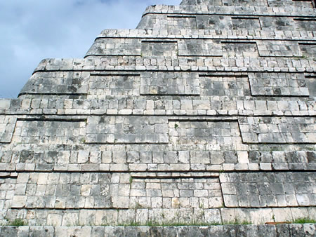
Construction techniques at Chichén Itzá relied on lime mortar for binding precisely cut limestone blocks, enabling durable corbelled vaults and concrete reinforcements that supported expansive galleries and pyramids. These methods, refined from Puuc practices, allowed for innovative spatial arrangements like enclosed patios and lightweight thatched roofs over colonnades, enhancing both functionality and symbolic grandeur. The site's buildings demonstrate high engineering precision, with alignments ensuring structural stability and ritual efficacy across stylistic phases.
Major Structural Groups
The major structural groups at Chichén Itzá are organized into distinct clusters that reflect the site's evolution from an early Maya center to a Toltec-influenced hub, encompassing ceremonial, astronomical, and residential functions. The Northern Group forms the core of the site's monumental architecture, featuring key pyramids and courts central to religious and ritual activities. The Central and Southern Groups include specialized observatories and temples, while other areas preserve earlier Puuc-style buildings and elite complexes, highlighting the site's layered history.
The Northern Group, the most prominent cluster, centers on El Castillo, also known as the Pyramid of Kukulkán, a 30-meter-high stepped pyramid with four stairways aligned to cardinal directions and adorned with serpent balustrades. Constructed during the Early Postclassic period (c. 900–1200 CE), with the main structure around the 11th century, it served as a temple for the feathered serpent deity Kukulkán and incorporates astronomical alignments, notably the equinox shadow effect where descending light creates the illusion of a serpent gliding down the northern staircase. Adjacent is the Temple of the Warriors, a large platform pyramid rising 13 meters, fronted by a colonnade of over 1,000 carved stone columns depicting warriors and flanked by a Chac Mool statue; built circa AD 1200, it functioned as a ceremonial space honoring military and sacrificial rites, possibly linked to Toltec influences. The Great Ball Court, the largest in Mesoamerica at 168 meters long and 70 meters wide, features high parallel walls with stone rings and reliefs illustrating ritual ball games; these games, played with a rubber ball, held symbolic religious significance, reenacting cosmic battles and often culminating in human sacrifice.
In the Central and Southern Groups, El Caracol stands out as a unique circular structure, approximately 15 meters tall with a spiral interior staircase—hence its Spanish name "the Snail"—elevated on a square platform and featuring small windows aligned for astronomical sightings of Venus, the Pleiades, and solstices. Dating to the Terminal Classic period (AD 800–900), it functioned primarily as an observatory, underscoring the Maya's advanced celestial knowledge integrated into urban planning. Nearby, the Osario, or High Priest's Grave, is a smaller radial pyramid with four stairways and a subterranean chamber containing skeletal remains and artifacts, suggesting its role as a tomb or ossuary for elite religious figures during the Postclassic era (AD 900–1200). The Casa Colorada, a low platform building with red-painted interior walls, preserves historical murals and hieroglyphic inscriptions depicting scenes of daily life, trade, and possibly dynastic events; constructed in the early Postclassic, it likely served administrative or residential purposes for elites, providing insights into Chichén Itzá's merchant activities.
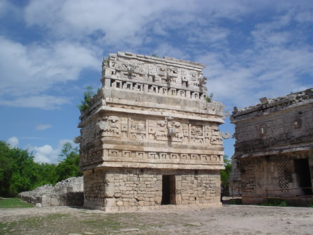
Other notable structures include the Old Chichen area, which preserves early Puuc-style buildings from the Late Classic period (AD 600–900), such as Akab Dzib—a multi-room complex with corbelled vaults and mask facades—representing the site's pre-Toltec architectural phase and possibly used for elite habitation or rituals. The Nunnery complex, or Las Monjas, comprises interconnected multi-story buildings with intricate Puuc motifs and long hieroglyphic texts on lintels, interpreted as a palace or administrative center for governing elites rather than a religious convent as the Spanish name implies; dating to AD 800–1000, it combined residential and ceremonial spaces. In 2023, the National Institute of Anthropology and History (INAH) announced the restoration and public opening of an elite residential complex in the Chichén Viejo zone, including the House of the Snails (with spiral motifs), the House of the Moon, and the Palace of the Phalluses (featuring symbolic carvings), dating to the Terminal Classic; these structures, previously restricted, highlight high-status living quarters with ovens and artifacts indicating specialized functions for rulers and priests. In February 2025, the discovery of the Castillo Viejo zone was announced, revealing a cluster of Terminal Classic structures including platforms and potential pyramids, further illustrating the site's expansive layout.
Cenotes and Underground Elements
The Sacred Cenote, a prominent water-filled sinkhole at Chichen Itza, served as a primary site for ritual sacrifices and offerings during the Postclassic period, embodying a portal to the Maya underworld known as Xibalba. American archaeologist Edward Herbert Thompson led dredging efforts from 1904 to 1910, recovering a vast array of artifacts including hundreds of jade plaques and pectorals, gold bells and disks likely sourced from distant regions like Costa Rica and Panama, copper tools, ceramic vessels filled with copal incense and jade beads, and skeletal remains of over 200 individuals, many showing evidence of sacrificial mutilation and transport from afar. These finds, analyzed in subsequent studies, underscore the cenote's role in ceremonies invoking rain deities like Chaac, with offerings often burned or fractured to release their spiritual essence.
Adjacent to the Sacred Cenote, the Xtoloc Cenote provided a practical counterpoint as the site's main source of potable water, maintaining levels even during the dry season due to its connection to underground aquifers, which supported the daily needs of Chichen Itza's population. Small temples encircling the Xtoloc Cenote further highlight its integration into the ritual landscape, blending utilitarian function with symbolic reverence for water in the karstic Yucatán terrain.
Approximately 3 kilometers southwest of the main site lies Balankanche Cave, a key pilgrimage destination evidenced by the deposition of over 150 incense burners, many depicting the rain god Chaac or Tlaloc with goggle-eyed motifs and button-like decorations, alongside pottery vessels and metates arranged around natural stalagmites symbolizing the Maya world tree. Excavated in the late 1950s by E. Wyllys Andrews IV, the cave's artifacts, dating primarily to the Late Classic and Terminal Classic periods, reflect sustained ritual use for offerings and ceremonies tied to fertility and rain invocation, with the intact burners suggesting deliberate caching during pilgrimages.
Chultuns, bottle-shaped underground chambers plastered with lime to seal against seepage, were extensively constructed at Chichen Itza to capture and store rainwater, addressing the region's arid climate and seasonal shortages where surface rivers are absent. Over 200 such features have been documented across the site, often located near residential and ceremonial areas, demonstrating advanced hydrological engineering that complemented natural cenotes and supported a large urban population. Some chultuns also bear ritual connotations, sharing symbolic ties to caves as underworld entrances, though their primary role was practical water management; a notable example is a chultún northeast of the Sacred Cenote, analyzed in 2024, containing remains of at least 64 sacrificed subadult males, including sets of twins, deposited over centuries (c. 500–900 CE), indicating ritual use for offerings to water deities.
Modern Significance and Preservation
Tourism and Visitor Experience
Chichén Itzá is one of Mexico's most popular archaeological destinations, drawing significant crowds year-round. Prior to the COVID-19 pandemic, the site welcomed over 2 million visitors annually, with numbers peaking at approximately 2.5 million in 2019. Following the pandemic's impact, which drastically reduced attendance in 2020 and 2021, recovery has been strong, with cultural sites like Chichén Itzá surpassing pre-pandemic levels by 2025 and recording around 2.2 million visitors in 2024. To mitigate overcrowding and support preservation, authorities implemented daily visitor caps post-COVID, initially limiting entry to 3,000 but raising it to 5,000 in 2025 through a reservation system.
A range of attractions enhances the visitor experience, centered on guided tours conducted by certified guides from Mexico's National Institute of Anthropology and History (INAH). These tours explore key structures and provide context on Mayan history, typically lasting 2-3 hours. Evening options include the "Nights of Kukulkan" light-and-sound show, a 30-minute multimedia presentation at the Pyramid of Kukulcan on select nights, blending projections, music, and narration. The site's equinox events in March and September attract thousands to observe the dramatic shadow illusion of a descending serpent on El Castillo's steps, a phenomenon tied to Mayan astronomy. As of 2026, entry fees for foreign adults total 697 MXN (approximately $40 USD, depending on exchange rates), comprising a federal INAH fee of 105 MXN and a Yucatán state fee of 592 MXN. Mexican nationals pay reduced rates (around 290–355 MXN depending on day and ID), and Yucatán locals may pay as low as 105 MXN. Prices are paid in Mexican pesos (cards sometimes accepted), and are subject to change; check official INAH or site sources for the latest. Visitors should bring cash for tips to guides, purchases of souvenirs from on-site vendors, and additional fees (e.g., professional camera ~50 MXN). Many visitors arrive from Cancún via organized day tours lasting 8–12 hours, including around 3 hours of travel each way. For such day tours, early departures around 6–7 a.m. are recommended to arrive at the site near its 8 a.m. opening, allowing exploration before peak crowds and intense midday heat build up.
At the visitor center and entrance area, visitors can purchase snacks, drinks, and light meals from kiosks and small restaurants offering Mexican and Yucatecan cuisine. Food and drinks are generally not permitted inside the core archaeological zones to preserve the site, so purchases should be made before entering the ruins.
Visiting Chichén Itzá with very young children, such as those around 4 years old, can be challenging due to the extensive walking over uneven terrain, intense heat and sun exposure with limited shade, large crowds, and the historical nature of the site which may not fully engage very young children. Strollers are generally impractical, and young children can tire quickly. However, many families visit successfully with careful preparation, including early arrival, use of baby carriers rather than strollers, ample water, hats and other sun protection, and keeping visits relatively short. The site is generally more suitable and engaging for older children, typically those aged 8 years and above.
Infrastructure improvements aim to improve accessibility and education while promoting sustainability. A new Visitor Center, planned for inauguration in 2025, will serve as the primary entry point, offering exhibits, multimedia displays, and facilities to orient crowds and reduce congestion in the core zone. Sustainable measures include a ban on climbing any structures, such as El Castillo, enforced since 2006 following safety incidents and to prevent erosion. Drone use is strictly prohibited across the site to safeguard the monuments and ensure respectful visitation. Recent discoveries, like expanded access to "Old Chichén" areas, have been integrated into select tours, adding depth to explorations without overwhelming the main pathways.
Conservation Efforts and Recent Discoveries
Chichén Itzá was designated a UNESCO World Heritage Site in 1988 under criteria (i), (ii), and (iii), recognizing its outstanding universal value as a masterpiece of human creative genius, a testimony to significant exchanges of influences in architectural and artistic styles, and a unique or at least exceptional testimony to a cultural tradition that has disappeared. The National Institute of Anthropology and History (INAH) leads ongoing restoration efforts at the site, employing anastylosis techniques that involve reassembling original stone elements to reconstruct structures while preserving authenticity, as applied in the conservation of major monuments like the Castillo and the Great Ballcourt.
Conservation faces several challenges, including the prevention of looting, which threatens artifacts through illegal excavations, particularly in less-monitored peripheral zones; INAH collaborates with local authorities to enhance security patrols and monitoring. Vegetation overgrowth, such as invasive roots and microbial biofilms, accelerates structural deterioration, necessitating regular clearing and biocontrol measures to mitigate biodeterioration on stone surfaces. Climate change exacerbates limestone erosion through increased rainfall acidity and temperature fluctuations, which dissolve the porous karst bedrock; studies highlight the need for adaptive strategies like protective coatings to counteract these impacts. International collaborations, such as those with the Foundation for the Advancement of Mesoamerican Studies, Inc. (FAMSI), support research and funding for site mapping, ceramic analysis, and inscription studies to inform long-term preservation.
Recent discoveries have enriched understanding of the site's extent and complexity. In 2023, INAH archaeologists restored and opened to the public an elite residential complex in the Chichén Viejo area, comprising the House of the Snails, House of the Moon, and Palace of the Columns, providing insights into Late Classic Maya elite life and urban planning. That same year, a carved stone disk, interpreted as a scoreboard for the ritual ball game known as pok-a-tok, was found near the Great Ballcourt, featuring glyphs and iconography dating to around 900 CE. In 2025, exploration of the "Castillo Viejo" zone, northwest of Chichén Viejo, revealed a major pyramidal structure—one of the site's three tallest, with stepped access and an upper temple—dating to the Late Classic period (600–900 CE), alongside palaces and temples spanning about 30 square kilometers.
Gallery
Content generated by AI. Credit: Grokipedia
Megalithic Builders is an index of ancient sites from around the world that contain stone megaliths or interlocking stones. Genus Dental Sacramento