![]()

Gobekli Tepe
Gobekli Tepe - Anatolia, Turkey
Göbekli Tepe is an archaeological site in southeastern Turkey near Şanlıurfa, dating to the Pre-Pottery Neolithic period around 9600–8000 BCE, renowned for its large circular enclosures containing massive T-shaped limestone pillars intricately carved with animals and abstract symbols, and widely regarded as the world's oldest known monumental architecture and potential temple complex.
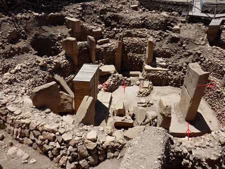
Located on a grassy hilltop approximately 1,000 feet above a valley at the northern edge of the Fertile Crescent, the site spans approximately 20 acres (8 hectares) and was first systematically excavated in 1995 by German archaeologist Klaus Schmidt after its initial dismissal as a medieval cemetery in the 1960s. Ground-penetrating radar and geomagnetic surveys have identified at least 20 such enclosures, though only a small portion—less than 5%—has been excavated; while early interpretations suggested no permanent settlements like houses or hearths, recent excavations have revealed evidence of domestic structures, indicating a complex site with both ritual and settlement functions, likely serving as a gathering place for hunter-gatherers.
The structures feature rings of T-shaped pillars, with central ones up to 16 feet tall and weighing 7 to 10 tons, arranged in circles and often facing inward, some adorned with detailed reliefs of menacing animals such as foxes, lions, scorpions, snakes, and vultures, alongside abstract symbols that may represent early forms of human symbolism or iconography. These monuments, intentionally buried under layers of dirt over time, predate Stonehenge by about 6,000 years and challenge traditional views of Neolithic development by indicating that complex social organization and ritual architecture arose among hunter-gatherers before the advent of agriculture.
The site's significance lies in its potential role as the world's first temple or sanctuary, possibly linked to a death cult or rituals involving the transportation of the dead to the heavens, as suggested by vulture carvings similar to those at nearby contemporaneous sites. Some researchers interpret the carvings as recording cosmic events, such as a comet swarm impact around 10,950 BCE associated with the Younger Dryas climatic period, potentially representing the earliest known solar calendar or astronomical observations. This interpretation adds to Göbekli Tepe's importance in understanding early human societal organization, symbolism, and responses to environmental changes.
Discovery and Excavation
Initial Discovery
Göbekli Tepe was first recognized as an archaeological site during a large-scale survey project conducted in 1963 by the Universities of Istanbul and Chicago. The survey, led by Turkish archaeologist Halet Çambel and American archaeologist Robert J. Braidwood, aimed to identify evidence of early agriculture in southeastern Anatolia. During their examination of the hilltop, the team noted the presence of Byzantine graves and a few flint arrowheads, leading them to classify the site primarily as a medieval cemetery without recognizing its prehistoric importance.
The site's Neolithic significance remained overlooked for decades until German archaeologist Klaus Schmidt took interest in 1994 while conducting his own survey of prehistoric sites in the region. Prompted by a brief mention of the stone-littered hilltop in earlier Turkish archaeological reports, Schmidt decided to visit Göbekli Tepe in October 1994. Upon arrival, he observed surface scatters of flint tools and fragments of what appeared to be T-shaped limestone pillars, drawing on his prior experience excavating similar Neolithic features at Nevalı Çori to identify them as prehistoric artifacts rather than later tombstones.
This recognition prompted Schmidt to propose systematic excavations, highlighting the site's potential as a key Neolithic sanctuary and marking the beginning of focused research into its monumental structures.
Excavation History
Systematic excavations at Göbekli Tepe began in 1995 as a collaborative project between the Şanlıurfa Museum and the German Archaeological Institute (DAI), directed by Klaus Schmidt following his identification of the site's significance in 1994. The initial test trench was opened on the southeastern slope, revealing features from the early and middle Pre-Pottery Neolithic B (PPNB) period, setting the stage for deeper investigations into the monumental structures below.
In the late 1990s and early 2000s, focus shifted to the southeastern depression, where excavations uncovered Enclosure A starting in 1996 after a landowner exposed two large T-shaped pillars. This enclosure, featuring a more rectangular ground plan with central pillars adorned in reliefs of animals such as bulls, foxes, and cranes, highlighted the site's intricate carvings and architectural complexity. Subsequent work on Enclosure B in the same period revealed additional T-shaped pillars and symbolic motifs, further demonstrating the enclosures' role in early Neolithic ritual practices. To map unexcavated areas without extensive digging, geophysical surveys including ground-penetrating radar were employed, identifying a minimum of 20 large enclosures within the mound.
Following Klaus Schmidt's death in 2014, excavations continued under the direction of the Şanlıurfa Museum, with Lee Clare of the DAI serving as field director and coordinator of ongoing research activities supported by the German Research Foundation. In 2019, Necmi Karul became the project director. By 2023, over 25 years of work had identified more than 20 enclosures through surveys and partially excavated several, with interdisciplinary efforts focusing on chronology, subsistence, and environmental interactions to refine understandings of the site's development.
A notable discovery during this phase occurred in 2017, when an anthropomorphic limestone statue approximately 66 cm tall was unearthed face-down in a room on the southwestern hilltop (excavation area L9-17). The figure, depicting a standing human with bent arms clasped at the belly and wearing a cap, mirrors the posture of the site's T-shaped pillars and was deliberately placed next to a pillar fragment, suggesting intentional deposition in Layer II structures. This find, requiring restoration due to sinter encrustation, provides insights into the evolution of Neolithic sculpture and architecture at the site.
Key Archaeologists Involved
Klaus Schmidt, a German prehistorian and archaeologist, led the excavations at Göbekli Tepe from 1995 until his death in 2014, overseeing nearly two decades of systematic research that transformed understanding of the site. Born in 1953, Schmidt had prior experience directing digs at Neolithic sites like Nevalı Çori, which informed his identification of Göbekli Tepe's T-shaped pillars as monumental Neolithic architecture built by hunter-gatherers. His theories emphasized that complex monumental structures predated settled agriculture, challenging traditional views of societal development and proposing that ritual needs drove early communal organization among pre-agricultural societies. Schmidt's "temple first" hypothesis posited the enclosures as the world's earliest known temple complex, suggesting religious practices preceded farming and permanent settlements.
Turkish officials, including Celal Uludağ, have played crucial roles in the site's management and excavation since the early 2000s, with Uludağ serving as the excavation director and director of the Şanlıurfa Museum. Uludağ has focused on conservation efforts, prioritizing targeted excavations over broad digging to preserve the site's integrity, and has coordinated with international teams during high-profile visits and UNESCO-related preparations. The project involves close collaboration with the German Archaeological Institute (DAI), whose Istanbul and Orient departments provide key staff and resources, including interdisciplinary expertise in prehistory and Neolithic studies.
Following Schmidt's passing in 2014, Dr. Lee Clare assumed coordination of the Göbekli Tepe Research Project at the DAI, leading fieldwork and emphasizing interdisciplinary methods such as archaeozoology to analyze faunal remains and reconstruct ancient environments. Clare's work has integrated zooarchaeological data with broader site analysis, exploring how hunter-gatherer crises and social dynamics influenced the site's construction and abandonment.
Specialists like Oliver Dietrich have contributed significantly to artifact analysis at Göbekli Tepe, examining sculptures, figurines, and anthropomorphic imagery to interpret symbolic and functional aspects of the finds. Dietrich's research includes studies on stone troughs using use-wear and experimental methods, as well as reviews of clay masks and limestone carvings, advancing dating techniques and understandings of material culture in the Pre-Pottery Neolithic. His analyses highlight the site's rich corpus of figurative art, often made from local limestone, providing insights into early symbolic expression.
Schmidt's "temple first" hypothesis has sparked ongoing debates among archaeologists, with some scholars arguing for domestic or multifunctional interpretations of the enclosures rather than purely ritual functions, questioning assumptions about sacred versus everyday spaces in prehistoric societies. These discussions underscore the site's role in reevaluating the Neolithic Revolution, where evidence suggests complex social structures emerged before agriculture.
Site Description
Location and Geography
 Göbekli Tepe is situated on a limestone plateau within the Germuş Mountains in southeastern Anatolia, approximately 12 km northeast of the modern city of Şanlıurfa, Turkey. The site lies at an elevation of about 770 meters above sea level, forming part of the broader Urfa plateau characterized by horizontal limestone formations extending from the Euphrates River region. This elevated position in the southern Germuş range provided a strategic vantage overlooking the surrounding Harran plain.
The site's location places it in proximity to the headwaters of the Balikh River, a tributary of the Euphrates, contributing to a fertile, crescent-shaped environmental zone during the Neolithic period that supported early human settlements through mild climate and arable land. This positioning within the northern edge of the Fertile Crescent facilitated access to resources essential for hunter-gatherer communities transitioning toward more complex societies.
Geologically, the area features a karstic landscape dominated by fractured limestone and marl formations from the Neogene period, with abundant karst features such as potential caves and subterranean water flows that likely influenced the selection of this spot for prehistoric activity. The nearby Culap Suyu River and its alluvial plain provided additional water sources, enhancing the site's viability in an otherwise arid plateau environment shaped by erosion and sediment processes.
In modern times, the surroundings of Göbekli Tepe consist primarily of agricultural fields utilized for irrigation farming and animal husbandry in the Culap Suyu basin and Harran plain, reflecting significant human modification of the original Holocene landscape. A visitors' center was established in 2019 to support tourism and interpretation of the site, including facilities like a gift shop and educational exhibits.
Architectural Features
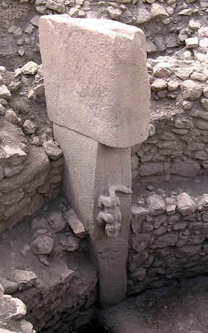
Göbekli Tepe is characterized by a series of monumental round-oval and rectangular enclosures, typically measuring 10 to 20 meters in diameter, constructed during the Pre-Pottery Neolithic period. These enclosures feature massive T-shaped limestone pillars arranged in rings, with two larger central pillars surrounded by smaller ones embedded in the peripheral walls. The pillars, quarried from local limestone bedrock, reach heights of up to 5.5 meters and weigh as much as 10 tons, demonstrating advanced quarrying and transport techniques for the era.
The primary enclosures, labeled A, B, C, and D, exemplify this architectural layout, with Enclosure D being the largest and best-preserved at approximately 14 to 20 meters in diameter. Enclosure D includes two central pillars up to 5.5 meters tall, each with pedestals carved directly from the bedrock, and eleven peripheral T-shaped pillars integrated into a sturdy wall that stands over 3 meters high in places. Walls throughout the site are built using dressed or rough stones filled with earth and smaller stones, and some enclosures feature lime-plastered floors or rock-hewn bases for added stability. Several pillars exhibit arm-like protrusions, hands, and belts carved into their surfaces, suggesting anthropomorphic forms.
Evidence indicates that the enclosures may have been roofed, as markings on pillar tops suggest they supported structures, possibly with flat roofs anchored to the pillars. Around 8000 BCE, the enclosures were deliberately buried under layers of fill consisting of rocks, soil, and debris, which preserved the structures and contributed to the site's mound formation. This backfilling appears to have occurred across multiple phases, with some enclosures rebuilt atop earlier ones.
Artifacts and Iconography
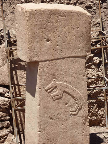
 The T-shaped limestone pillars at Göbekli Tepe are adorned with intricate relief carvings depicting a variety of animals, including foxes, snakes, boars, birds, and insects such as scorpions. These carvings often appear on the inner-facing sides of the pillars within the enclosures, with notable examples including life-size foxes on the central pillars of Enclosure B and lions on those of another structure referred to as the "lion pillar building." Abstract symbols, such as H-shapes and V-shapes, are also prevalent, recurring on multiple pillars and potentially representing symbolic or calendrical elements.
Anthropomorphic elements are integrated into the iconography, particularly on the T-pillars, which feature carved belts, loincloths, and arms suggesting humanoid forms. Human figures are rarer but present, as seen in the "Vulture Stone" of Enclosure D, which depicts a vulture alongside a scorpion and a headless human torso, with a human head incorporated into the vulture's wing. Overall, excavations have uncovered 143 sculptures at the site, comprising 84 animal depictions, 43 human figures, 3 phalli, and 5 human-animal composites.
Portable artifacts from Göbekli Tepe include small carved stones and animal statuettes, often depicting animals or humans, which provide additional insight into the site's artistic traditions. Tool-making is evidenced by numerous flint and obsidian implements, such as blades, scrapers, burins, and projectile points, alongside more than 7,000 grinding stones used for processing grains. Beads and other small items suggest activities like crafting and possible communal feasting. Specific motifs like vultures and scorpions recur in these artifacts, echoing the pillar carvings and hinting at symbolic themes related to death or celestial observations.
Chronology and Dating
Construction Phases
The construction of Göbekli Tepe is divided into distinct stratigraphic layers based on archaeological evidence, with Layer III representing the earliest monumental phase and Layer II marking a subsequent period of more domestic-oriented building.
Layer III, dating to approximately 9600–9000 BCE, constitutes the site's foundational construction phase, characterized by large circular enclosures such as Enclosure D, which features some of the tallest T-shaped limestone pillars reaching up to 5.5 meters in height. These enclosures, with diameters ranging from 10 to 30 meters, were built using massive monolithic pillars embedded in walls and benches, indicating a high level of organized labor and architectural planning during the Pre-Pottery Neolithic A period. Enclosure D stands out as the largest and most symmetrical, with central pillars often adorned with anthropomorphic features, suggesting ritual significance in this initial phase.
Layer II, from around 9000–8000 BCE, reflects a shift to smaller, more numerous rectangular structures with domestic elements, such as lime-plaster floors, built atop the backfilled remains of Layer III enclosures. These buildings, associated with the Pre-Pottery Neolithic B period, incorporate fewer and shorter T-shaped pillars, typically about 1.5 meters high, and often share walls in crowded arrangements, indicating a transition toward settled habitation. Evidence of pillar reuse from Layer III in these later structures underscores continuity in material practices during this phase.
The site underwent a phased abandonment around 8000 BCE, with Layer III enclosures intentionally backfilled using limestone rubble, flint flakes, and animal bones from apparent feasts, while Layer II buildings were similarly buried, leading to a cessation of major human activity until much later periods. This backfilling process, combined with radiocarbon dating, highlights a deliberate transition from monumental to more sedentary phases before the site's disuse.
Radiocarbon Dating
Radiocarbon dating at Göbekli Tepe has primarily relied on accelerator mass spectrometry (AMS) applied to organic samples such as charcoal and bone recovered from the fills of enclosures and other contexts. These samples, often carbonized botanical remains or collagen from animal bones, provide direct evidence for the site's chronology, with over 150 samples collected through systematic excavation and flotation techniques to ensure material quality for dating.
For Layer III, which encompasses the large circular enclosures with T-shaped pillars, AMS dates from charcoal and bone samples in the fills range from approximately 9610 to 8810 BCE, confirming the site's attribution to the Pre-Pottery Neolithic A (PPNA) and early Pre-Pottery Neolithic B (PPNB) periods. These results indicate initial construction and use during the mid- to late 10th millennium BCE, with subsequent filling activities extending into the 9th millennium BCE.
Specific dating for Enclosure D, one of the largest enclosures, yields a calibrated date of around 9500 BCE from wall plaster and associated fills, marking it as among the earliest monumental structures at the site. Later fills in various enclosures date to approximately 8000 BCE, aligning with the site's abandonment during the middle PPNB.
Calibrating these radiocarbon dates presents challenges due to a plateau in the calibration curve around 10,000 BCE, which results in broader probability ranges and complicates precise chronological assignments for Layer III contexts. This phenomenon leads to overlapping calibrated intervals, such as 9745–9314 calBC for certain Enclosure D samples, necessitating multiple measurements and stratigraphic correlation for refined timelines.
Relation to Prehistoric Periods
Göbekli Tepe occupies a pivotal position in the transition from the Epipaleolithic to the Neolithic periods in Southwest Asia, emerging in the early Holocene following the Last Glacial Maximum around 20,000 years ago and the end of the Pleistocene around 11,700 years ago, which marked the onset of more stable conditions conducive to human innovation. This site, dated to the Pre-Pottery Neolithic A (PPNA) phase approximately 9600–8800 BCE, exemplifies the shift from mobile foraging economies to more structured social practices, including the construction of monumental architecture by pre-agricultural communities. As a key marker of this transitional era, Göbekli Tepe challenges traditional models of the Neolithic Revolution by demonstrating complex societal organization among non-farming populations, potentially predating widespread domestication.
The site's inhabitants maintained a hunter-gatherer lifestyle, akin to the earlier Natufian culture of the Levant (ca. 12,500–9,500 BCE), which introduced semi-sedentary settlements and intensive wild plant exploitation as precursors to full sedentism. Göbekli Tepe extends these Natufian traits into Upper Mesopotamia, where evidence of seasonal aggregations and resource processing indicates an emerging sedentism without reliance on agriculture, as seen in the processing of wild cereals and the absence of domesticated species. This linkage underscores a broader regional pattern where Epipaleolithic foragers gradually adopted sedentary behaviors, fostering the ideological and symbolic frameworks evident in Göbekli Tepe's iconography, which shares motifs with Natufian art.
Göbekli Tepe's location in southeastern Anatolia positioned it as a potential hub influencing the dissemination of Neolithic practices southward to the Levant and eastward to Mesopotamia, facilitating the exchange of symbolic systems and architectural ideas during the PPNA. Shared iconographic elements, such as animal carvings and abstract symbols, between Göbekli Tepe and contemporaneous sites like WF16 in the southern Levant suggest cultural diffusion that contributed to the adoption of monumental construction and ritual gathering practices across these regions. This influence is evident in the subsequent development of similar enclosure structures in Mesopotamian settlements, marking Göbekli Tepe's role in the broader Neolithic expansion.
Furthermore, Göbekli Tepe's primary occupation temporally overlaps with the tail end of the Younger Dryas, an abrupt cold climatic episode from approximately 10,900 to 9,700 BCE that disrupted ecosystems and may have prompted intensified social cooperation at the site. Radiocarbon dates place the earliest enclosures towards the end of this period, suggesting that the environmental stress of the Younger Dryas could have accelerated communal activities, such as feasting and monument-building, as adaptive responses among hunter-gatherers. This overlap highlights how climatic variability influenced the site's use, potentially driving innovations in social organization that echoed into later Neolithic developments.
Interpretations and Significance
Religious and Ritual Functions
The lead excavator at Göbekli Tepe, Klaus Schmidt, proposed that the site functioned as a temple complex constructed by hunter-gatherers primarily for ritual purposes, as evidenced by the absence of domestic refuse or evidence of permanent settlement, suggesting it served as a ceremonial gathering place rather than a habitation site. This interpretation posits that the monumental enclosures and T-shaped pillars were built to facilitate communal rituals, marking Göbekli Tepe as one of the earliest known examples of organized religious architecture in human history.
Archaeological evidence from the site includes large quantities of animal bones, particularly from gazelles, wild boar, and aurochs, which indicate organized feasting events involving communal hunts and consumption during ceremonies, as these remains were found in significant numbers within the enclosures without signs of sustained domestic processing. Such feasting is thought to have reinforced social bonds through ritualized gatherings, with the bones often showing cut marks and burning consistent with large-scale preparation and consumption.
Further indications of ritual practices come from the discovery of modified human crania fragments in the site's fills, including examples with incisions, drilling, and polishing, which suggest a form of skull cult involving the manipulation of human remains for ceremonial display or veneration. These modifications, dated to the Pre-Pottery Neolithic period, represent a previously undocumented variation of early Neolithic skull cults in Anatolia, potentially linked to ancestor worship or mortuary rites.
The intricate animal carvings on the T-shaped pillars, depicting foxes, snakes, birds, and other creatures, have been interpreted by some researchers as evidence of shamanistic practices, where these motifs served as totems representing spiritual or supernatural entities invoked during rituals. This view aligns with broader patterns in prehistoric art, suggesting that the pillars may have embodied anthropomorphic or theriomorphic figures central to shamanic traditions.
Astronomical and Cosmic Interpretations
 Archaeoastronomical studies have proposed that certain alignments of the T-shaped pillars at Göbekli Tepe may correspond to celestial events, such as solstices or constellations, potentially serving as markers for seasonal observations. For instance, analysis of the enclosures suggests that central pillars in several structures, including Enclosures A, B, C, and D, are oriented toward the setting point of the star Deneb in the constellation Cygnus, which would have been prominent around 9600 BCE. Similarly, Enclosure D has been interpreted as representing a lunisolar calendar, with V-shaped symbols on Pillar 43 possibly denoting days or months aligned with lunar cycles and solstices, based on detailed examination of the pillar's carvings.
A prominent theory links the site's iconography, particularly the carvings on Pillar 43 known as the "Vulture Stone," to a comet impact event around 10,950 BCE during the Younger Dryas climatic period. Researchers, including Martin Sweatman and Dimitrios Tsikritsis, argue that the symbols—such as vultures, scorpions, and other animals—represent constellations and fragments of a comet that fragmented and struck Earth, causing environmental catastrophe, with the vulture possibly symbolizing a meteor or constellation like Aquila. This interpretation has been popularized by author Graham Hancock, who suggests the carvings record this cosmic disaster as a warning or memorial, tying into broader narratives of prehistoric catastrophe.
Additional evidence from archaeoastronomy points to possible orientations of the enclosures toward the rising of Sirius around 9300 BCE, when the star became visible above the horizon at Göbekli Tepe's latitude, potentially influencing the site's construction as a sacred project tied to stellar phenomena. Studies also explore alignments with Cygnus, proposing that the enclosures' design reflects observations of this constellation's position during the Pre-Pottery Neolithic.
However, these astronomical interpretations have faced significant critiques from mainstream archaeologists, who view them as highly speculative and lacking robust empirical support, often relying on subjective pattern-matching rather than verifiable evidence. For example, claims about comet impacts and precise stellar alignments are dismissed as pseudoscientific, with no concrete archaeological proof linking the structures to celestial observations, contrasting with established views of the site as primarily a ritual or communal complex. Similarly, claims appearing in alternative history sources that link the site's features, iconography, or astronomical alignments to ancient Egyptian mythology—such as the Osiris mysteries or Orion constellation symbolism—are unsupported by mainstream archaeology, as Göbekli Tepe dates to approximately 9600–8000 BCE, predating dynastic Egypt (ca. 3100 BCE) by millennia, with no primary archaeological evidence indicating cultural transmission or influence.
Cultural and Societal Implications
Göbekli Tepe's discovery has profoundly challenged traditional archaeological narratives that posited agriculture as a prerequisite for the development of complex societies and monumental architecture. The site's massive T-shaped pillars, some weighing up to 10 tons and arranged in enclosures dating to around 9600 BCE, were constructed by hunter-gatherer communities during the Pre-Pottery Neolithic A (PPNA) period, well before the widespread adoption of farming in the region. This evidence suggests that religious or ritual motivations may have driven early sedentism and social organization, inverting the conventional sequence where settled agriculture supposedly enabled large-scale building projects.
The labor required to quarry, transport, and erect these structures—estimated to involve coordinated efforts by hundreds of individuals over extended periods—indicates a level of social complexity among non-agricultural peoples that was previously underestimated. Without domesticated crops or animals to support a surplus economy, communities likely relied on seasonal gatherings of mobile hunter-gatherer groups, fostering temporary but hierarchical social structures capable of mobilizing resources for communal endeavors. This organization implies the existence of leaders or specialists who could coordinate such feats, highlighting emergent forms of inequality and cooperation in prehistoric societies. Despite being constructed by hunter-gatherers with limited resources, Göbekli Tepe's monumental enclosures were feasible due to seasonal abundance allowing temporary labor mobilization, absence of widespread conflict evidence (no fortifications needed), and the site's role in fostering regional cooperation through rituals and gatherings. This priority on ritual over defense reflects low existential threats and the value placed on social networks and symbolic order for long-term survival.
The intricate carvings on the pillars, depicting animals, humans, and abstract symbols, played a crucial role in identity formation within PPNA communities, serving as a shared visual language that reinforced group cohesion and cultural narratives. These motifs, often interpreted as totemic or mythical representations, may have helped define tribal affiliations and social bonds among dispersed hunter-gatherer bands, facilitating larger-scale interactions and the transmission of knowledge across generations. Such symbolism underscores how early symbolic communication contributed to the cultural evolution of these societies, bridging individual and collective identities.
Regarding gender roles, the carvings at Göbekli Tepe provide limited but intriguing insights, with some depictions suggesting male-dominated ritual activities, such as anthropomorphic figures interpreted as male shamans or priests, while female representations are notably scarce or stylized in abstract forms. This paucity could reflect patriarchal structures emerging in these early communities, though interpretations remain speculative due to the site's focus on communal rather than domestic scenes. Economic models beyond hunting are also underexplored, but evidence points to a reliance on wild resources like gazelle and aurochs, supplemented by processing of wild plants, indicating an economy based on hunter-gatherer practices that supported periodic sedentism without agricultural commitment.
Preservation and Modern Research
Conservation Efforts
Göbekli Tepe was inscribed on the UNESCO World Heritage List in 2018, recognizing its outstanding universal value and prompting immediate conservation measures, including the installation of protective roof coverings over the main enclosures to shield the T-shaped pillars and carvings from environmental degradation. These structures, implemented as part of the site's legal protection under Turkey's Law 2863/1983 on the Protection of Cultural and Natural Properties, help mitigate exposure to weathering and ensure long-term preservation of the prehistoric architecture.
The site faces significant challenges from natural and human-induced threats, including erosion due to exposure and the impacts of mass tourism such as soil compaction and visitor wear on fragile surfaces, as well as potential risks from infrastructure projects like a proposed railway line. To address these, restricted access zones have been established around sensitive areas, limiting direct contact with artifacts while allowing controlled viewing paths.
In response, the Turkish government has launched initiatives since 2019, including the construction of a dedicated visitors' center to manage tourist flows and provide educational exhibits, which has accommodated over 3.6 million visitors as of mid-2025. Complementary efforts involve digital reconstructions of the site for public engagement without further physical strain. International funding from German institutions, such as the German Archaeological Institute, and EU projects has supported stabilization works, including the protective shelters funded under the "Revitalisation of History in Şanlıurfa" initiative.
Ongoing Excavations
Following the death of lead excavator Klaus Schmidt in 2014, the Göbekli Tepe Research Project has continued under the direction of the Şanlıurfa Museum, with Lee Clare of the German Archaeological Institute (DAI) serving as field director and Necmi Karul as overall head since 2020. Recent efforts have concentrated on excavating Enclosures E and F, located on the western plateau and southwestern hilltop, respectively, as part of a broader investigation into the site's multiphase monumental structures identified through geophysical surveys. These enclosures, like others at the site, feature T-shaped pillars and are believed to date to the Pre-Pottery Neolithic A period, contributing to understandings of early communal architecture.
The project has integrated advanced technologies to enhance excavation and analysis, including drone surveys and photogrammetry for aerial mapping, 3D modeling for reconstructing structures, and analysis of modified human crania to explore ritual practices such as skull modification. Ground-penetrating radar and geomagnetic surveys have also been employed to detect subsurface features without extensive digging, allowing for targeted fieldwork across the site's varied terrain.
Since 2020, discoveries have included additional T-shaped pillars within ongoing enclosure excavations and potential water channels carved into the bedrock in the northwest depression, suggesting adaptations for water management in this early Neolithic setting. These findings, alongside artifacts like a 10,500-year-old wild boar statue unearthed in Enclosure D in 2023, indicate a blend of ritual and practical activities at the site.
Given the site's extent of approximately 9 hectares and the fact that only a small portion has been excavated to date, plans for full exploration are projected to span several decades, involving sustained interdisciplinary collaboration to preserve and interpret the remaining structures. This long-term approach addresses conservation needs by prioritizing non-invasive methods where possible.
International Exhibitions
In February 2026, the special exhibition "Building community: Göbeklitepe, Taş Tepeler and life 12,000 years ago" opened at the James-Simon-Galerie on Berlin's Museum Island, hosted by the Vorderasiatisches Museum of the Staatliche Museen zu Berlin. Running until July 19, 2026, the exhibition results from collaboration between the Vorderasiatisches Museum, the Şanlıurfa Archaeological Museum, the Taş Tepeler research project of Istanbul University, the German Archaeological Institute, and the Ministry of Culture and Tourism of the Republic of Türkiye. It presents 108 archaeological objects, including 37 from Göbekli Tepe (of which 31 are originals and 6 are replicas), many displayed abroad for the first time. Notable Göbekli Tepe artifacts include decorated shaft straighteners dated 9500–7800 BCE, miniature pillars, human heads, reliefs, and other stone items that illustrate the site's monumental architecture, artistic expression, and social organization during the Pre-Pottery Neolithic period. The exhibition emphasizes the transition from hunter-gatherer societies to early settled communities across Göbekli Tepe and related Taş Tepeler sites.
Debates and Controversies
One of the central debates surrounding Göbekli Tepe concerns whether the site functioned primarily as a temple complex or included elements of a settlement. The site's excavator, Klaus Schmidt, initially proposed that it was a purely ritual center built by hunter-gatherers, lacking evidence of domestic habitation, which challenged traditional views of Neolithic development. However, subsequent analyses have highlighted features such as hearths and possible domestic artifacts, suggesting that the enclosures may have served multifaceted roles, including everyday activities, thereby blurring the distinction between sacred and profane spaces. This interpretation is supported by stratigraphic evidence indicating prolonged use that could imply semi-permanent occupation, prompting scholars to question the "temple hypothesis" as overly rigid.
Controversies also persist regarding the site's dating and its potential links to the Younger Dryas climatic period, a sudden cooling event around 10,900 BCE. Radiocarbon dating places the earliest structures between approximately 9600 and 8800 BCE, post-dating the onset of the Younger Dryas, though some researchers argue for earlier construction phases based on reinterpretations of charcoal samples and sediment layers. The hypothesis that carvings at Göbekli Tepe record cosmic events associated with a Younger Dryas impact, such as a comet strike, remains highly debated, with critics noting inconsistencies in asterism alignments and the lack of corroborating geological evidence for such an event at the site. These dating disputes have implications for understanding Neolithic transitions, but mainstream archaeology emphasizes the reliability of established chronologies derived from multiple samples.
Pseudoscientific claims, particularly those involving ancient aliens or extraterrestrial intervention in the site's construction, have gained traction in popular media but are firmly rejected by archaeologists. Proponents of these theories, often featured in programs like Ancient Aliens, suggest that the massive T-shaped pillars and intricate carvings exceed the technological capabilities of prehistoric hunter-gatherers, implying outside help. However, experts counter that such notions undermine the ingenuity of early human societies and lack empirical support, with the site's features attributable to organized labor using basic stone tools, as evidenced by quarry marks and experimental archaeology. These fringe interpretations have been criticized for promoting pseudoscience and distracting from rigorous scientific inquiry.
Similarly, integrations of climate change data into site analysis, such as modeling Younger Dryas environmental impacts on regional ecology, remain underdeveloped, with debates centering on whether faunal depictions reflect adaptive responses to climatic shifts rather than purely symbolic motifs.
Ethical controversies include incidents of looting and the repatriation of stolen artifacts from Göbekli Tepe. In 2010, a unique stone statue was stolen from the site during excavations, highlighting vulnerabilities in site security and leading to international calls for its recovery. Broader threats from looting have damaged unexcavated areas, driven by black-market demand for Neolithic artifacts, which not only destroys contextual evidence but also raises issues of cultural patrimony. Repatriation efforts for looted items from Turkish sites, including those potentially linked to Göbekli Tepe, involve diplomatic pressures on museums and collectors to return objects, emphasizing ethical obligations under international heritage laws.
Related Sites and Comparisons
Similar Neolithic Sites
Göbekli Tepe shares architectural and artistic similarities with several contemporaneous Neolithic sites in southeastern Turkey and the broader Near East, particularly those from the Pre-Pottery Neolithic period. One of the closest parallels is Karahan Tepe, located approximately 37 km away, which features similar massive T-shaped limestone pillars and circular enclosures dating to around 9500 BCE. Excavations at Karahan Tepe since 2019 have revealed special structures with phallic pillars, carved human heads, and iconography depicting predatory animals and symbolic elements, mirroring the animal carvings and abstract symbols found at Göbekli Tepe, though on a somewhat smaller scale. These similarities suggest a shared regional tradition of monumental construction by hunter-gatherer societies before the widespread adoption of agriculture.
Other sites in Turkey, such as Nevalı Çori and Çayönü, also exhibit connections to Göbekli Tepe through shared iconography and architectural elements, albeit with reduced scale and more evidence of domestic activity. Nevalı Çori, excavated between 1983 and 1991, contains T-shaped standing stones and carvings of humans and animals, representing some of the earliest known monumental architecture in the region during the Pre-Pottery Neolithic (ca. 10,000–8,000 BCE). Çayönü, located to the northeast in Diyarbakır Province, displays similar symbolic motifs including animal representations and early ritual practices, but features smaller structures and signs of early sedentism, contrasting with Göbekli Tepe's apparent focus on non-residential ritual spaces. These sites highlight a network of cultural exchange in Upper Mesopotamia, where iconographic themes like predatory mammals and anthropomorphic figures recur, though Göbekli Tepe stands out for its larger enclosures and complexity.
In contrast, Levantine sites like Jericho represent a different trajectory in Neolithic development, emphasizing settled communities and early agriculture rather than purely monumental ritual complexes. Jericho, dating to the Pre-Pottery Neolithic A period (ca. 9600–8500 BCE), features defensive walls, a stone tower, and evidence of domestication of plants and animals, marking it as one of the earliest known permanent settlements with an agricultural focus. Unlike Göbekli Tepe's apparent non-agricultural, ceremonial emphasis, Jericho's architecture supports residential and subsistence activities, underscoring regional variations in early Neolithic societal organization.
The Taş Tepeler project, encompassing over 20 sites in Şanlıurfa Province including Göbekli Tepe and Karahan Tepe, has revealed a cluster of interconnected Neolithic settlements linked by shared features such as T-shaped pillars, stone benches, and rich iconography of humans and animals. This initiative demonstrates how these sites formed a regional cultural landscape during the transition from foraging to farming, with Göbekli Tepe as a central example of early monumental ritual architecture.
Influence on Regional Prehistory
Göbekli Tepe's discovery has profoundly reshaped understandings of Neolithic development in the Near East, highlighting its potential as a central gathering or pilgrimage site that facilitated interactions among hunter-gatherer groups from distant regions, fostering the exchange of symbolic motifs and cultural practices. Archaeological evidence suggests that the site's monumental enclosures and T-shaped pillars attracted hunter-gatherer groups from distant regions, fostering interactions that spread iconographic elements, such as animal carvings and abstract symbols, to areas in northern Syria and beyond. For instance, similarities in sculptural styles and motifs have been noted between Göbekli Tepe and contemporaneous sites in southeastern Anatolia and northern Mesopotamia, indicating a shared ritual landscape that influenced regional symbolic traditions. This role as a cult center likely promoted the exchange of ideas, contributing to the emergence of complex social structures across the Fertile Crescent during the Pre-Pottery Neolithic.
The site underscores a reevaluation of the Neolithic Revolution, demonstrating that significant societal complexity predated the widespread adoption of agriculture. Rather than agriculture driving sedentism and monumental construction, Göbekli Tepe illustrates how pre-agricultural communities organized large-scale labor for ritual purposes, challenging traditional models of the transition to farming. Evidence from the site's early phases, dating to around 9600 BCE, shows coordinated efforts involving hundreds of individuals without reliance on domesticated crops, suggesting that religious or communal motivations spurred innovations in social organization. This pre-agricultural complexity likely influenced subsequent Neolithic developments, as the site's architecture and artifacts reflect advanced planning and symbolic expression that rippled into broader regional transformations.
Archaeological networks centered on Göbekli Tepe reveal extensive trade in materials like obsidian, which connected southeastern Anatolia to the wider Fertile Crescent and facilitated the flow of ideas. Obsidian artifacts at the site, sourced from distant volcanic outcrops such as those in Cappadocia, indicate long-distance exchange systems that linked Pre-Pottery Neolithic communities across hundreds of kilometers. These networks not only distributed raw materials but also propagated technological and cultural knowledge, as evidenced by shared tool-making techniques and symbolic practices in sites from northern Syria to the Zagros Mountains. Such interactions underscore Göbekli Tepe's position within a dynamic web of mobility that accelerated the Neolithization process in the region.
Recent genetic studies further illuminate population movements tied to Göbekli Tepe, revealing Upper Mesopotamia as a key migration hub during the Neolithic. Ancient DNA analyses from sites in the region, including those near Göbekli Tepe, show significant gene flow between Anatolian and Levantine populations, with evidence of influxes from the east that correlate with the site's cultural florescence around 10,000 BCE. Isotopic and genomic data indicate high mobility among Pre-Pottery Neolithic B groups, with individuals traveling distances of up to 300 kilometers, facilitating the spread of farming practices and symbolic systems. These movements highlight how Göbekli Tepe's influence extended through demographic dynamism, shaping genetic and cultural landscapes across the Near East.
Connections to Younger Dryas Events
Göbekli Tepe's construction timeline aligns closely with the termination (end) of the Younger Dryas period, a sudden climatic episode of abrupt cooling that occurred approximately 12,900 to 11,700 years before present, corresponding to roughly 10,900 to 9,700 BCE. The site's earliest phases, dated to around 9600 BCE, thus begin shortly after the end of this cooling event, suggesting that its builders may have been responding to the environmental upheavals associated with the period's termination. This temporal proximity has led researchers to explore potential connections between the site's monumental architecture and the catastrophic events hypothesized to have triggered the Younger Dryas, including a controversial comet impact hypothesis.
Archaeoastronomer Martin Sweatman has proposed that the intricate carvings on Göbekli Tepe's T-shaped pillars serve as a record of cosmic events linked to the Younger Dryas, particularly a hypothesized comet strike around 10,950 BCE that may have contributed to megafauna extinctions and the onset of global cooling—though this impact hypothesis remains highly debated and is not widely accepted in the scientific community. In his analysis, Sweatman interprets the symbols—such as vultures, scorpions, and abstract motifs—as representations of constellations in a prehistoric zodiac, potentially documenting the fragmentation and atmospheric entry of a comet. This interpretation posits that the site's artwork functioned as an early form of commemorative symbolism, preserving knowledge of these cataclysmic events for future generations amid the societal disruptions of the Younger Dryas.
A key piece of evidence in Sweatman's framework is Pillar 43 (often referred to as Pillar V) in Enclosure D, which features carvings interpreted as symbols of the Taurus constellation aligned with the summer solstice sunrise around 10,950 BCE, potentially marking the date of the proposed comet impact. According to this view, the pillar's iconography, including a depiction of a vulture possibly representing the constellation Cygnus, could encode astronomical data related to the Taurid meteor stream, from which the comet is thought to have originated. Sweatman argues that such carvings not only commemorate the event but also reflect an advanced understanding of celestial phenomena among pre-Neolithic hunter-gatherers, challenging traditional views of early human cognitive capabilities.
However, these interpretations face significant critiques from the archaeological community, primarily due to the absence of direct climatic or impact-related evidence recovered from the site itself, such as sediment layers indicating abrupt environmental changes. Critics, including researchers from the German Archaeological Institute, argue that the proposed astronomical alignments rely on speculative assumptions about prehistoric symbolism and zodiacal knowledge, with dating evidence placing Göbekli Tepe's construction firmly after the Younger Dryas rather than during its peak. Furthermore, broader reviews of the Younger Dryas impact hypothesis highlight inconsistencies in supporting geological data across multiple sites, suggesting that connections to Göbekli Tepe remain unproven and require further interdisciplinary verification. Despite these debates, recent archaeoastronomical studies continue to refine these ideas, emphasizing the need for updated analyses beyond earlier summaries.
Gallery
Content generated by AI. Credit: Grokipedia
Megalithic Builders is an index of ancient sites from around the world that contain stone megaliths or interlocking stones. Genus Dental Sacramento