![]()

Abusir Necropolis
Necropolis - Abusir, Egypt
Abusir is an ancient Egyptian necropolis located approximately 20 kilometers south of Cairo on the western bank of the Nile River, serving as the principal burial ground for pharaohs of the Fifth Dynasty (c. 2494–2345 BC) during the Old Kingdom period. The site encompasses pyramids dedicated to kings including Sahure, Neferirkare Kakai, Neferefre, and Nyuserre Ini, alongside mortuary temples, a sun temple linked to the solar cult of Ra, mastaba tombs for officials, and later pillar tombs from the Late Period. Archaeological work, notably by Czech expeditions since the late 19th century and intensifying in the 20th, has revealed structural details of pyramid complexes and administrative records illuminating Old Kingdom funerary practices and state operations.
Location and Environment
Geographical Position
Abusir is situated on the western bank of the Nile River in the Memphite necropolis, approximately 25 kilometers southwest of central Cairo and about 15 kilometers south of the Giza pyramid plateau. Positioned north of Saqqara by roughly 8 kilometers, it forms a key intermediate site within the chain of ancient Egyptian funerary complexes extending from Giza southward to Dahshur. This location on the desert plateau overlooking the floodplain provided a symbolic and practical extension of the necropolis serving the nearby capital of Memphis, approximately 20 kilometers to the south.
The site's topography features an elevated limestone plateau at the edge of the Nile Valley escarpment, with coordinates around 29°54′N 31°12′E, offering stable bedrock for pyramid foundations and quarrying local stone. The plateau's position facilitated visibility toward the cultivation zone and ancient urban centers, while its arid desert environment preserved structures over millennia. Abusir's geographical centrality in the Fifth Dynasty shifted focus from Giza's Fourth Dynasty developments, emphasizing its role in the evolving Memphite burial landscape.
Climatic and Geological Factors
 Abusir is situated in a hyper-arid desert environment, where annual rainfall averages less than 25 mm, primarily occurring in sporadic winter events. This extreme aridity has facilitated the preservation of organic remains at the site by limiting moisture-related decay processes, such as microbial activity and hydrolysis, which are prevalent in more humid climates. However, the absence of significant precipitation does not preclude erosional forces; persistent winds carrying sand particles contribute to abrasion on exposed surfaces, gradually wearing down architectural features over millennia.
Geologically, the Abusir plateau consists predominantly of Late Eocene limestone formations, including nummulitic limestone beds rich in fossilized foraminifera, overlaid by clay-limestone and marl layers. These strata offered a locally abundant and relatively soft material ideal for quarrying, enabling efficient extraction and shaping for monumental construction. The limestone's calcareous composition provides inherent stability for foundational structures, yet its microfossil content and bedding planes render it vulnerable to thermal expansion and contraction, potentially leading to microfractures.
Proximity to the ancient Nile floodplain has historically influenced subsurface hydrology at Abusir, with periodic flooding elevating groundwater tables and introducing soluble salts into the soil and bedrock. Capillary rise of this brackish water to the surface promotes salt crystallization within pores of the limestone bases, exerting expansive pressures that exacerbate deterioration through efflorescence and subflorescence mechanisms. Such geological-hydrological interactions underscore the site's vulnerability to long-term environmental degradation despite its elevated desert position.
Historical Overview
Origins and Fifth Dynasty Development
Abusir emerged as a royal necropolis during the Fifth Dynasty of Egypt's Old Kingdom, around 2450 BCE, coinciding with a shift in burial practices from the preceding dynasty's sites at Giza and Saqqara. This transition began under Userkaf, the dynasty's founder, who constructed the solar temple Nekhen-Re adjacent to Abusir, emphasizing the site's alignment with the era's growing solar theology centered on the god Ra. Userkaf's own pyramid remained at Saqqara, but his initiative laid groundwork for Abusir's development as a hub for royal commemorative architecture tied to heliopolitan cult practices.
 Sahure, Userkaf's successor and the second pharaoh of the Fifth Dynasty (reigned c. 2458–2446 BCE), established Abusir as the primary location for royal pyramids by building his own complex there, thereby abandoning earlier necropolises. The choice of Abusir likely stemmed from its strategic proximity to Heliopolis, approximately 15 kilometers northeast, facilitating symbolic and logistical connections to Ra's cult center and enabling efficient resource transport via the Nile. This relocation reflected a deliberate ideological pivot toward solar veneration, as evidenced by the integration of sun temple elements into the necropolis planning.
Subsequent Fifth Dynasty rulers expanded Abusir's role through successive pyramid constructions, demonstrating coordinated state planning. Neferirkare Kakai (c. 2446–2426 BCE) erected his pyramid adjacent to Sahure's, followed by Neferefre (c. 2419–2416 BCE) and Niuserre (c. 2416–2392 BCE), whose monuments exhibit linear alignments oriented toward the ancient Nile channel. These developments underscore centralized administrative control, with evidence from quarry marks and administrative papyri indicating systematic labor mobilization and material allocation under royal oversight. The necropolis's layout, including provision for valley temples linked by causeways, highlights premeditated urban-scale engineering to support perpetual cultic activities.
Later Period Expansions and Reuse
Following the decline of monumental pyramid construction in the Old Kingdom, Abusir experienced renewed burial activity during the Saite Period of the 26th Dynasty (c. 664–525 BCE), characterized by the excavation of deep shaft tombs for elite non-royal individuals rather than pharaonic complexes. These structures, often exceeding 10 meters in depth, reflect an adaptation of Late Period funerary architecture emphasizing secure underground chambers amid threats of tomb robbery. The Czech Institute of Egyptology's excavations have uncovered several such tombs in the Saite-Persian cemetery south of the Fifth Dynasty pyramids, including the tomb of Iufaa, a high official whose burial goods and sarcophagus highlight the site's role in accommodating provincial administrators and military figures.
A prominent example is the shaft tomb of Wahibre-mery-Neith, discovered in 2022, dated to the late 26th or early 27th Dynasty (c. early 5th century BCE). Wahibre-mery-Neith, titled "Commander of Foreign Soldiers" (likely overseeing Nubian or Carian mercenaries integrated into Egyptian forces), interred his remains in a looted but artifact-rich tomb yielding faience ushabtis, pottery, and inscribed limestone blocks attesting to his status under Persian influence. This burial underscores Abusir's appeal for foreign-influenced elites during the transition to Achaemenid rule, with the site's limestone quarries providing ready materials for shaft linings and chapels.
 In the Ptolemaic (305–30 BCE) and Roman Periods, activity at Abusir diminished to sporadic reuse, lacking the scale of earlier eras; evidence includes quarry extraction of casing stones from dilapidated pyramids for Memphis-area construction and isolated finds of Greco-Roman pottery sherds near older mastabas, suggesting minor squatter occupation or ritual visits. The necropolis persisted as a sacred locus due to its ancient association with Osiris—reflected in the toponym "Pr-Wsr" (House of Osiris)—facilitating limited funerary cults tied to the god's resurrection mythology, though without new monumental temples or extensive cemeteries comparable to Saqqara. This contrasts sharply with the Old Kingdom's royal focus, evidencing a shift toward decentralized, less grandiose commemoration amid Egypt's integration into Hellenistic and imperial economies.
Monumental Features
Major Royal Pyramids
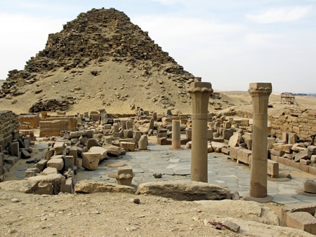
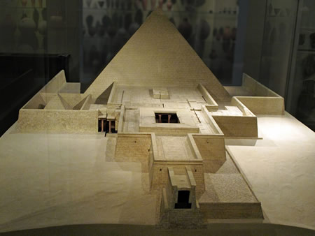
The major royal pyramids at Abusir, erected during Egypt's Fifth Dynasty, served as central elements of funerary complexes designed to facilitate the pharaoh's eternal afterlife through burial provisions and ritual cult practices. These structures, built primarily from local limestone cores encased in finer Tura limestone, marked a shift toward smaller-scale true pyramids compared to earlier Fourth Dynasty monuments, emphasizing solar theology integration via adjacent sun temples and symbolic motifs. Construction involved horizontal accretion layers of roughly hewn blocks, with descending corridors leading to subterranean burial chambers intended to house sarcophagi and grave goods, though most were violated in antiquity.
Sahure's pyramid, dating to circa 2458 BCE, stands as the inaugural major royal monument at Abusir, with a base measuring approximately 78 meters and an original height of 47-48 meters at a slope of about 50 degrees. Its core comprised stepped layers of limestone, later smoothed with casing stones, and featured a standard substructure including a descending passage, antechamber, and burial chamber aligned north-south for solar associations. The adjacent causeway bore exceptional reliefs depicting military victories over Libyan tribes and naval expeditions, alongside solar barque representations symbolizing the pharaoh's journey with the sun god Ra, underscoring the era's emphasis on royal prowess and divine kingship.
Neferirkare's pyramid, constructed around 2446 BCE, was ambitiously planned as Abusir's largest at a base of 105 meters and intended height of 72 meters, but remained incomplete, initially built as a six-stepped structure reaching 52 meters before partial conversion attempts toward a true pyramid form. This reflects evolving techniques amid resource constraints, with the mortuary temple layout incorporating open courts and offering halls linked to a nearby sun temple for Re worship, highlighting administrative and religious synergies. The substructure's granite elements and chamber designs aimed to deter intruders, though eventual robbery compromised its funerary integrity.
Niuserre's pyramid, from circa 2416 BCE, exemplifies refined Fifth Dynasty engineering with a base of 79 meters, height of about 52 meters, and precise Tura limestone casing over a limestone core, achieving a smoother profile via careful block alignment. Internal chambers included a burial room with corbelled roof and evidence of ancient breaches, such as blocked passages and scattered debris from looters targeting the sarcophagus and canopic equipment. The complex's design prioritized defensive features and solar alignments, integrating the pharaoh's tomb with ritual spaces to perpetuate offerings and ka sustenance.
Secondary Pyramids and Subsidiary Structures
The secondary pyramids at Abusir primarily served queens, royal consorts, or possible co-regents, functioning as satellites to the larger royal complexes and reflecting scaled-down versions of the main pyramid architecture with adaptations for elite female burials. These structures, dating to the Fifth Dynasty (c. 2494–2345 BCE), typically featured smaller bases and integrated substructures emphasizing mortuary continuity with the primary king's tomb, often aligned along the same axes toward Heliopolis. Unlike the monumental kings' pyramids, they incorporated variations such as abbreviated causeways or reliance on adjacent royal temples for ritual access, underscoring hierarchical dependencies in the necropolis layout.
The pyramid of Khentkaus II, located in southern Abusir near the complex of Neferefre, is attributed to a queen possibly the mother or wife of that king, constructed around 2420 BCE during the mid-Fifth Dynasty. Measuring approximately 25 meters square at the base and originally rising to about 17 meters, its core utilized local limestone with limited casing, and excavations revealed a substructure with a burial chamber accessed via a descending corridor, including remnants of a sarcophagus. Unique elements include rock-cut features in the substructure and debated titulary evidence from associated papyri suggesting elevated status—potentially pharaonic or queen mother—though consensus favors her as a royal consort based on inscriptional analysis of her name and titles linking her to Neferefre's lineage.
Further north, the unfinished pyramid associated with Reneferef (also known as Shepseskare or Neferefre in variant attributions) exemplifies abrupt construction halt, begun c. 2419 BCE but abandoned after minimal groundwork, with only foundational trenches and a partially excavated substructure completed before evident dynastic disruption. Planned as a step pyramid initially, measuring about 65 meters per side, its rapid cessation—limited to weeks of labor—signals potential succession crises or early royal death, as no superstructure was raised and the site repurposed minimally for later burials. This contrasts with completed queens' pyramids, highlighting instability in late Fifth Dynasty royal projects at Abusir.
Subsidiary structures accompanying these secondary pyramids included small chapels for offerings and symbolic resurrection rites, often annexed to the eastern face and featuring niches for stelae or statues to facilitate eternal cultic service tied to the main pyramid's solar alignment. Boat pits, rectangular excavations for ritual vessels representing the solar barque, were integrated around the pyramid bases to evoke the pharaoh's (or consort's) journey with Ra, distinct from standalone mastabas by their enclosure within the pyramid's temenos wall for unified funerary symbolism; examples from Abusir excavations yielded wooden models or pit linings, underscoring practical and ideological roles in resurrection theology without evidence of full-scale ships. These elements prioritized ritual efficacy over grandeur, adapting core pyramid ideology for secondary burials.
Mastabas and Elite Tombs
The mastabas at Abusir served as primary burial structures for high-ranking officials and courtiers during the Fifth Dynasty, underscoring a rigid social hierarchy where tomb size, location, and elaboration correlated with proximity to royal power and administrative influence. These rectangular, flat-roofed superstructures, often built of mudbrick with limestone casing, enclosed subterranean burial chambers and chapels adorned with reliefs depicting the deceased in daily activities and receiving offerings, thereby ensuring eternal sustenance. Unlike royal pyramids, mastabas emphasized personal status through features like serdabs—sealed chambers housing statues of the tomb owner for ritual interaction—and offering tables inscribed with formulas invoking provisions from the living.
A prime example is the mastaba of Ptahshepses, vizier and son-in-law of King Niuserre (reigned c. 2420–2392 BCE), excavated by the Czech Institute of Egyptology between 1960 and 1974. This monument, the largest and most architecturally complex non-royal tomb of the Old Kingdom, spans approximately 5,000 square meters with a multi-room chapel, pillared courtyard, and serdab containing statue niches, reflecting Ptahshepses's rise from royal manicurist to chief administrator. Reliefs in the chapel depict offerings presented at tables before the vizier, alongside scenes of statue transport and storage, symbolizing his role in funerary cults and state rituals. The tomb's eastern orientation and integration of offering halls further highlight elite access to solar and mortuary practices tied to the adjacent royal pyramids.
In the Abusir South cemetery, Fifth Dynasty elite tombs further illustrate stratified social positioning, with larger mastabas of viziers and priests situated nearer the royal complexes of Neferirkare and Khafre's causeway, denoting favored status and administrative ties to pyramid construction. Tombs here, such as those of officials like Kaaper and Inti, feature courtyards, false doors, and serdabs with over twenty documented statues across the site, evidencing a deliberate emulation of royal iconography among the upper echelons. This spatial hierarchy—elite burials clustered centrally versus peripheral lower officials—reveals a merit-based yet kin-linked bureaucracy, where tomb elaboration signaled roles in temple estates and royal workshops.
Burial assemblages from these mastabas include copper model tools—such as chisels, adzes, and drills—deposited in female and official interments, indicative of specialized crafts like masonry and woodworking linked to pyramid-building economies. Faience models and miniature vessels, recovered from chambers like that of Nyankhseshat (tomb AS 104), represent provisioning and ritual economies, with copper artifacts analyzed as arsenical alloys sourced from Sinai or trade networks, underscoring elite oversight of resource extraction and metallurgical workshops. These goods, absent in lower-status graves, affirm the tombs' role in perpetuating occupational identities and economic dependencies on the state.
Temples and Ritual Complexes
The mortuary temples at Abusir functioned as focal points for the ongoing cult of the royal ka, incorporating halls, offering tables, and statue niches designed to facilitate perpetual rituals honoring the deified king. Sahure's mortuary temple, built around 2450 BCE adjacent to his pyramid, exemplifies this with its vast program of carved limestone reliefs spanning roughly 370 meters of interior walls, portraying processions of deities presenting offerings, royal expeditions symbolizing dominion over Nile-linked trade routes and foreign tribute, and scenes evoking abundance through symbolic maritime and fluvial motifs. These decorations, fragments of which survive in collections like the Egyptian Museum in Cairo and Berlin's Neues Museum, highlight the pharaoh's divine legitimacy and ritual dependence on cosmic and terrestrial provision for eternal sustenance.
Sun temples nearby, such as those at Abu Ghurab, advanced Fifth Dynasty solar theology by linking pharaonic immortality to Ra's daily cycle, featuring open courts, low obelisks, and alabaster altars for solar veneration integrated with royal ancestor worship. Neferirkare Kakai's Setib-Re ("Site of the Heart of Ra"), constructed circa 2400 BCE and noted in ancient Egyptian records as the most expansive sun temple of the era, served as an architectural precursor to Heliopolitan complexes, incorporating elements like elevated platforms and ritual spaces that prefigured later monumental solar shrines.
The Abusir papyri, administrative texts unearthed from Neferirkare's mortuary temple and datable to the late Fifth Dynasty (circa 2350 BCE), document the practical execution of these cults, specifying daily offerings of bread, beer, and meat to ka statues alongside inventories of ritual paraphernalia. These records detail priestly rotations via phyles—teams serving in shifts to ensure uninterrupted ceremonies—reflecting a structured hierarchy that sustained the temples' operations through organized provisioning and oversight.
Excavations and Discoveries
Initial Explorations (19th-early 20th Century)
The first systematic survey of the Abusir necropolis was conducted in the 1830s by British engineer and Egyptologist John Shae Perring as part of his broader examinations of pyramids south of Giza, where he produced basic measurements, noted structural alignments among the main pyramids, and identified key features such as casing remnants and substructures. During these efforts, Perring recovered a limestone block inscribed with the name of Neferirkare from the vicinity of that king's pyramid, providing early evidence linking the site to Fifth Dynasty rulers.
In the 1840s, the Prussian expedition under Karl Richard Lepsius visited Abusir during its multi-year campaign across Egyptian sites, producing the first detailed map of the necropolis and incorporating its pyramids into Lepsius's comprehensive catalog of 67 Egyptian pyramids, which numbered Abusir's monuments and described their states of preservation. These surveys relied on rudimentary tools like theodolites and manual sketching, yielding limited artifact recovery amid heavy prior quarrying and erosion but establishing the site's layout relative to Giza and Saqqara.
Early 20th-century work advanced with German Egyptologist Ludwig Borchardt's excavations of Sahure's pyramid complex from March 1907 to 1908, which exposed well-preserved limestone reliefs in the funerary temple depicting royal expeditions, divine offerings, and processions, alongside clear signs of ancient tomb robbery such as breached chambers and scattered debris. Borchardt's methods, though constrained by the era's emphasis on elite artifacts over stratigraphic recording, documented over 10,000 square meters of original temple decoration fragments, confirming Sahure's Fifth Dynasty attribution through cartouches and iconography. These pioneering efforts provided foundational plans and attributions but produced modest yields due to unsystematic digging and site disturbance, prioritizing visible monuments over subsurface features.
Mid-20th Century Systematic Digs
In the post-World War II era, the Czech Institute of Egyptology initiated organized excavations at Abusir in 1960, marking a shift toward stratigraphic analysis that clarified the temporal sequences of mastaba tombs and their subsidiary features. Initial efforts targeted the large mastaba of Ptahshepses, vizier to Fifth Dynasty kings, with fieldwork spanning seven seasons until 1974 under directors such as Zbyněk Žába and Miroslav Verner. These digs delineated construction phases through layered deposits, establishing relative chronologies for elite burials contemporaneous with royal pyramids like those of Sahure and Neferirkare, and revealing alignments with broader Memphite necropolis patterns.
From the mid-1970s, Verner directed the expedition's focus to Abusir South, a previously under-explored sector south of the main pyramids, employing geodetic surveys to produce comprehensive site maps. This work uncovered clusters of non-royal tombs and administrative artifacts, including cylinder seals bearing titles of officials involved in pyramid temple provisioning, which provided evidence of centralized logistical support for royal mortuary cults. Stratigraphic profiling in these areas further refined mastaba dating, linking them to late Fifth Dynasty transitions via ceramic and architectural typologies.
Substructure explorations at Niuserre's pyramid during these campaigns exposed corbelled burial chamber roofs reinforced with timber beams, a technique analyzed as an adaptation for structural stability amid regional seismic activity, with cedar wood samples dated to the king's reign circa 2420 BCE. These findings, preserved in situ due to limited prior disturbance, highlighted engineering refinements over earlier Fifth Dynasty designs, informing reconstructions of construction methodologies without reliance on later intrusive modifications.
Contemporary Research (Late 20th-21st Century)
Since the early 2000s, the Czech Institute of Egyptology at Charles University has led systematic excavations in Abusir West, focusing on Late Period shaft tombs and yielding multidisciplinary insights into mummification practices. In 2021, the mission unearthed the largest embalming cache ever documented in Egypt, comprising 370 large pottery vessels filled with natron, resins, charcoal, and other desiccants used in the embalming process, dated to the 26th Dynasty around the 5th century BCE. This discovery, recovered from a 14-meter-deep well measuring 5.3 by 5.3 meters, provided direct evidence of industrial-scale mummification workshops adjacent to elite burials, highlighting the scale of Late Period funerary infrastructure.
The cache was linked to the nearby tomb of Wahibre-mery-Neith, a high official titled "Commander of Foreign Soldiers" who oversaw mercenary units likely of Carian or Ionian origin, excavated by the same mission and announced in 2022. The tomb's unique double-shaft design and preserved artifacts, including canopic jars and amulets, offered data on Late Period (26th-27th Dynasty) administrative roles and international trade, as the official's titles reflect Egypt's reliance on foreign military expertise during Persian influence.
Contemporary efforts have integrated geophysical techniques, such as magnetic surveys, to detect subsurface anomalies and map unexcavated shafts in Abusir's Old Kingdom necropolis, enabling non-invasive reconstruction of tomb layouts without prior disturbance. In parallel, satellite-based remote sensing has advanced site analysis; the 2023 publication The Pyramid Fields of Ancient Egypt: A Satellite Atlas by the Czech Institute compiled imagery to identify potential undiscovered features across Abusir's pyramid fields, updating prior mappings with high-resolution data on alignments and subsurface indications. These methods, combined with targeted digs, have expanded knowledge of Abusir's spatial organization and ritual economies into the 2020s.
Egyptological Significance
Architectural Transitions and Innovations
The pyramids at Abusir, built primarily during the Fifth Dynasty (c. 2494–2345 BCE), exemplify a pivotal shift in Egyptian pyramid architecture from the expansive, meticulously constructed monuments of the Fourth Dynasty at Giza to more compact and resourceful designs characteristic of subsequent eras. While Giza's structures, such as Khufu's Great Pyramid with its base measuring 230 meters and height of 146 meters, relied on precisely hewn limestone blocks for both core and casing, Abusir's pyramids adopted smaller scales and rubble-filled cores to address emerging constraints in labor and materials post the height of Old Kingdom pyramid-building. For instance, Neferirkare Kakai's pyramid featured a base of 104.6 meters and an intended height of 50 meters, utilizing local limestone rubble packed within retaining walls rather than uniform megalithic masonry, which accelerated construction but increased vulnerability to erosion and collapse over millennia.
This transition reflects empirical adaptations to resource pressures, as evidenced by the substitution of high-quality Tura limestone casings—sparingly applied in Abusir—with coarser local varieties for core filling, linked to diminishing yields from proximate quarries exhausted by prior mega-projects. Remnants of casing stones on pyramids like Sahure's reveal a decline in uniformity and fineness compared to Giza's polished exteriors, with petrographic analysis indicating higher porosity and impurity levels in Fifth Dynasty samples, causally tied to overexploitation of prime quarry faces. Such innovations prioritized structural feasibility over aesthetic perfection, enabling continued royal tomb construction amid fiscal strains inferred from reduced monument volumes—Neferirkare's pyramid held about one-tenth the mass of Khufu's.
Mortuary temple designs at Abusir further innovated by incorporating T-shaped halls, as in Sahure's complex, which optimized space for ritual processions while integrating columned porticos and offering chambers in a more modular layout than Giza's sprawling granite-heavy temples. Causeways connecting these temples to valley structures emphasized decorative reliefs over monumental length, with Sahure's 235-meter passage adorned in polychrome bas-reliefs depicting royal exploits and offerings, shifting focus from raw scale to narrative symbolism amid the era's stylistic evolution. These features underscore Abusir's role as an architectural laboratory, where empirical adjustments in fill techniques and ornamental priorities bridged Giza's engineering zenith to the decentralized pyramid traditions of the late Old Kingdom.
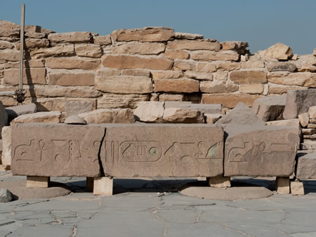
Abusir Papyri and Administrative Records
The Abusir Papyri consist of administrative documents primarily from the mortuary temple of Neferirkare Kakai, with major caches recovered during illicit excavations in 1893 and systematic digs in 1982. These hieratic texts, dating to the Fifth Dynasty around 2400 BCE, primarily cover the reigns of Neferirkare Kakai and Djedkare Isesi, offering direct evidence of temple operations through fragmented rolls and sheets. Unlike incidental inscriptions, they form coherent archives detailing routine bureaucracy, preserved in dumps within the temple's storage areas.
Key contents include duty rosters for priests organized into rotating phyles, ensuring continuous ritual service with specified shifts for personnel such as overseers and ritual assistants. Inventories list offerings like bread, beer, poultry, and cloth deliveries, alongside equipment such as vessels and tools, reflecting a self-sustaining temple economy reliant on state allocations and local estates. Fragments also reference cattle counts, periodic royal assessments of livestock that synchronized temple resources with national cycles, as seen in notations from Djedkare's era marking years by these events.
These records demonstrate rigorous accounting practices, with quotas for labor and provisions indicating a temple staff of several hundred, including priests, scribes, and laborers, managed through hierarchical oversight to track inputs and outputs. Detailed tallies of rations, such as monthly bread distributions, underscore the scale of operations, where discrepancies in deliveries prompted audits, evidencing mechanisms to mitigate mismanagement in resource handling. Overall, the papyri reveal a centralized yet vulnerable administrative framework, dependent on accurate reporting for sustaining cult activities.
Insights into Funerary and Solar Cult Practices
Reliefs from Abusir's pyramid causeways and temples depict solar barques carrying the sun god Ra, symbolizing the pharaoh's identification with Re's daily journey across the sky and resurrection at dawn, rooted in Heliopolis theology where the benben stone represented primordial creation and renewal. These motifs, appearing prominently in Fifth Dynasty structures like Sahure's complex, illustrate causal links between royal funerary architecture and solar cycles, with obelisks and barque shrines evoking eternal rebirth.
Integration of Osiris and Ra cults is evident in Abusir South mastabas from Nyuserre's reign (circa 2445–2421 BCE), where funerary offering formulas invoke Osiris alongside solar elements, suggesting rituals blending underworld resurrection with diurnal solar renewal. Mud-layered burials and clay artifacts in these tombs mimic Osiris's mythic dismemberment and regeneration, providing empirical evidence of elite adoption of Osirian rites within a solar-dominated framework unique to Abusir before the Sixth Dynasty.
Funerary provisioning evolved in Abusir mastabas through statues placed in serdabs, serving as proxies for the deceased in the afterlife, precursors to later ushabti figurines intended for labor. Excavations at Abusir South yielded over twenty such statues from late Fifth Dynasty tombs, indicating specialized provisioning for eternal service tied to solar kingship ideology. Compared to Saqqara's broader iconographic variety, Abusir exhibits denser solar motifs, as seen in Niuserre's adjacent sun temple, underscoring the site's cultic focus on Ra worship integrated with funerary Osirian practices.
Preservation and Challenges
Incidents of Looting and Damage
Evidence of ancient tomb robberies at Abusir is preserved in the archaeological record, including damaged sarcophagi and forced entries in non-royal tombs, such as one discovered in 2022 where looters had broken into the burial to plunder contents, leaving the outer coffin lid fractured. Similar intrusions affected mastaba tombs like AC 31, where excavation fills document multiple minor breaches and one major robbery event that disrupted the structure post-burial. These incidents reflect organized plundering likely occurring during Old Kingdom instability or shortly after interment, targeting funerary goods in the necropolis's pyramid and tomb complexes.
Over subsequent millennia, systematic stone quarrying inflicted extensive damage, with pyramid core and casing blocks extracted by "stone thieves" for reuse, progressively eroding superstructures from antiquity through the medieval era. This quarrying, driven by demand for limestone in Cairo's Islamic-period construction, reduced the once-monumental forms of structures like those of Sahure and Neferirkare to their current skeletal remains, though less intensively than at some neighboring sites.
In modern times, the 2011 Egyptian revolution triggered opportunistic looting at Abusir amid nationwide security breakdowns, with vandals removing inscribed stone blocks from tombs. This event contributed to broader site depredation, including attempts to dismember larger reliefs, exacerbating losses from political turmoil that enabled unchecked access to the unguarded necropolis.
Environmental and Developmental Threats
Rising groundwater levels and associated moisture infiltration have induced salt efflorescence on the limestone blocks of Abusir's pyramids, mobilizing soluble salts that crystallize and cause surface flaking and disintegration. A 2022 geoenvironmental analysis of Sahure's pyramid quantified this degradation through petrographic examination, revealing halite and gypsum crystals within pore spaces of the Tura limestone casing, accelerated by capillary rise from contaminated subsurface water since the 1970s alterations in Nile hydrology following the Aswan High Dam's completion.
Urban expansion from Cairo's metropolitan area, with the Greater Cairo population exceeding 20 million by 2020, has progressively encroached on the western desert fringes of the Memphite necropolis, including Abusir's southern periphery near Saqqara. This informal sprawl introduces mechanical stresses via nearby construction vibrations and increases pollution loads that exacerbate chemical weathering of exposed masonry.
Seismic events compound structural vulnerabilities, as demonstrated by the October 1992 Cairo earthquake (magnitude 5.8), which inflicted out-of-plane displacements, fractures, and localized collapses in Sahure's pyramid core and casing. The site's location on alluvial sediments amplifies ground shaking, promoting differential settlement and crack propagation in the pyramids' foundations.
Prevailing winds laden with abrasive sand particles drive ongoing surface erosion, manifesting as microstructural pitting and granular disintegration on exposed faces, as identified in field assessments of Sahure's pyramid masonry. This aeolian degradation, intensified during seasonal shamal winds exceeding 10 m/s, has removed outer layers of softer limestone variants over decades, heightening porosity and susceptibility to further dissolution.
Ongoing Conservation Initiatives
Since 2019, a joint Egyptian-German conservation project directed by Mohamed Ismail Khaled of the Supreme Council of Antiquities has focused on the pyramid of Sahura at Abusir, involving the removal of debris from interior chambers, consolidation of the substructure using original limestone blocks, and reconstruction of walls to avert further structural collapse. This effort, supported by the Antiquities Endowment Fund and affiliated with the University of Würzburg's Institute of Egyptology, employed 3D scanning and photogrammetry to document and map the antechamber and newly revealed storage magazines, enhancing preventive maintenance through precise architectural modeling. Outcomes include the stabilization of vulnerable areas and incidental discoveries of undocumented compartments, informing targeted interventions against erosion and subsidence.
Czech-Egyptian collaborations, ongoing through the Czech Institute of Egyptology since the early 2000s, have emphasized the treatment of limestone artifacts and tomb structures at Abusir, applying experimental consolidants such as nano-materials to decayed surfaces for the first time in the region. These initiatives target core stabilization in burial complexes, including the Naos statues from the Nefer tomb, by injecting penetrating agents to bind friable stone without altering original compositions. Complementary geodetic surveys and 3D modeling, as conducted on the Neferirkare pyramid in 2015, support long-term monitoring of structural integrity.
Site management plans influenced by the site's inclusion in the UNESCO-listed Memphis Necropolis have incorporated community involvement since the early 2020s to promote sustainable oversight, including local training in monitoring and threat assessment to mitigate environmental degradation. Recommendations from geoenvironmental studies advocate for integrated preventive strategies, such as groundwater control and visitor impact modeling, to preserve the necropolis's pyramid cores.
Post-2011 security measures, including reinforced fencing and increased patrols by Egyptian authorities, have been deployed across Abusir to address vulnerabilities exposed during the political transition, contributing to broader declines in reported illicit activities at Memphite sites following the initial surge in unauthorized digs. These enhancements align with national efforts to restore site guardianship, though challenges persist in remote sectors.
Gallery
Content generated by AI. Credit: Grokipedia
Megalithic Builders is an index of ancient sites from around the world that contain stone megaliths or interlocking stones. Genus Dental Sacramento