![]()

Gunung Padang
Gunung Padang - West Java, Indonesia
Gunung Padang is a megalithic archaeological site situated on an extinct volcano in Cianjur Regency, West Java, Indonesia, comprising a series of five terraced platforms constructed from arranged andesite and basalt stone blocks, forming the largest such complex in Southeast Asia at over 3 hectares in extent.
The structure exemplifies the Indonesian punden berundak tradition of stepped terraces linked to prehistoric megalithic rituals, with the uppermost terrace featuring prismatic column-like megaliths potentially aligned for astronomical observation, while lower levels incorporate columnar jointed lava formations modified by human activity. Traditionally dated through ceramics and stratigraphy to the late Neolithic through early historic periods (circa 2500 BCE to 1500 CE), the site reflects Austronesian cultural practices of ancestor veneration and sacred landscape alteration on a volcanic base.
A major controversy erupted in 2023 from geophysical surveys and core sampling purporting to reveal buried artificial layers dating to 25,000–27,000 years ago, implying Gunung Padang as a man-made pyramid predating known monumental architecture and challenging timelines of human technological capability during the Last Glacial Maximum; however, this interpretation relied on radiocarbon dating of bulk soil organic matter rather than datable artifacts or charcoal, conflating geological lava flows with construction, and was rejected by geologists and archaeologists for lacking empirical rigor, leading to the study's retraction in 2024 amid peer-review failures. The retraction underscores persistent challenges in distinguishing anthropogenic modification from natural volcanic stratigraphy at the site, with consensus favoring incremental prehistoric terracing atop a lava dome rather than a unified prehistoric megastructure. Designated a national heritage site since 1998, Gunung Padang continues to draw scrutiny for its potential to inform Southeast Asian prehistory, though unsubstantiated claims of extreme antiquity have fueled pseudoscientific narratives over verifiable data.
Location and Physical Description
Geographical Setting
Gunung Padang is an archaeological site located in Karyamukti village, Cianjur Regency, West Java province, Indonesia, approximately 50 kilometers southwest of Cianjur city. The site occupies the top of a hill formed by an extinct volcano, rising to an elevation of 885 meters above sea level. This positioning places it within the volcanic landscape typical of the region, characterized by rugged terrain and proximity to active geological features.
The surrounding geography includes the southern mountainous ranges of West Java, near the headwaters of the Cimandiri River, with undulating hills, volcanic ridges, and dense tropical forests enveloping the area. The hill's terraces extend over an area of about 3 hectares, with the highest point reaching around 960 meters in some descriptions, though the base elevation remains at 885 meters. This elevated, isolated setting contributes to the site's prominence in the local topography, facilitating its use as a megalithic complex amid a backdrop of fertile volcanic soil and seasonal tropical climate influences.
Site Layout and Terraces
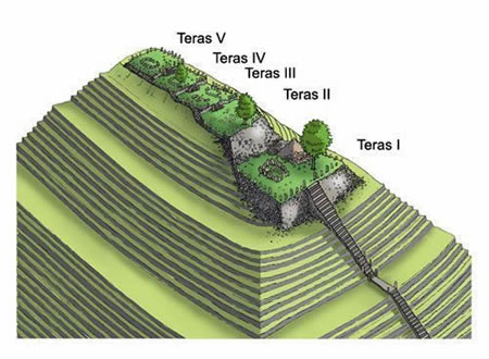
 Gunung Padang consists of five artificial terraces arranged in ascending order on the slopes of an extinct volcanic promontory in western Java, Indonesia. Numbered from the base upward, Terrace 1 forms the lowest and largest level, while Terrace 5 constitutes the highest and smallest summit platform. The terraces exhibit a progression from four trapezoidal shapes to one rectangular configuration at the top, oriented along a south-north axis.
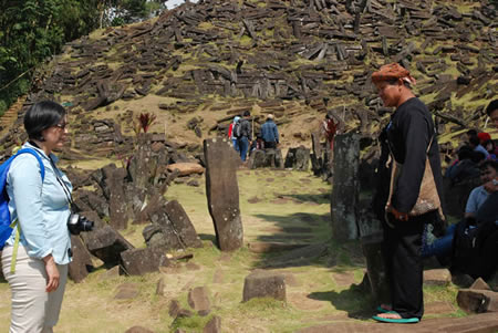
The terraces are interconnected by a central staircase of 370 andesite stone steps rising from the surrounding valley, flanked on either side by upright megalithic pillars measuring approximately 15–90 cm in width and up to 120 cm in height. Each terrace is supported by buttressing retaining walls and paved with rectangular arrangements of prismatic andesite blocks exhibiting natural columnar jointing, often hexagonal in cross-section. These megalithic structures cover the terrace surfaces, utilizing locally sourced volcanic rock.
Prominent features include the batu kecapi on Terrace 1, a five-foot-long andesite block capable of producing a resonant, deep tone when struck, and scattered upright stones along staircase edges that mark transitions between levels. The layout reflects a stepped, pyramid-like form adapted to the hill's topography, with diminishing terrace sizes toward the apex.
Historical Discovery and Early Investigations
Pre-20th Century Recognition
 Gunung Padang has long been recognized by the indigenous Sundanese people of West Java as a sacred site integral to their cultural and spiritual traditions, predating European colonial records. Local folklore attributes its construction to the semi-legendary King Siliwangi (Prabu Siliwangi), a figure associated with the historical Sunda Kingdom (circa 14th–16th centuries CE), who purportedly attempted to build a palace there in a single night through supernatural means, resulting in the terraced megalithic structure observed today. This narrative reflects broader Sundanese mythological views of the site as a manifestation of divine or royal intervention, though no contemporaneous written accounts from the pre-colonial era confirm the legend's details or timeline.
In Sundanese tradition, Gunung Padang exemplifies a punden berundak, a stepped megalithic platform typically used for ancestor veneration and ritual ceremonies, indicating its role in prehistoric and protohistoric religious practices among Austronesian-speaking communities. Such structures, common in western Java, underscore the site's pre-20th-century significance as a locus of communal memory and cosmology, with oral histories preserving knowledge of its artificial terraces and andesite pillars amid the natural volcanic landscape. Archaeological evidence, including surface pottery shards dated to the late Neolithic or early historic periods, supports ongoing human utilization, aligning with indigenous recognition of the hill as a modified sacred mound rather than mere topography.
Colonial-Era and Post-Independence Studies
The site of Gunung Padang was first noted in Western records during the Dutch colonial period by geologist Rogier Verbeek, who described it in 1896 as a mound with megalithic elements. In 1914, Dutch archaeologist N.J. Krom formally reported the site to colonial authorities, characterizing the upper terraces as an ancient cemetery composed of arranged stones, though he conducted no excavations and recommended further survey. These early colonial observations classified the visible structures as megalithic terraces rather than a unified monument, with limited documentation emphasizing surface features amid the site's use for local rituals; no systematic archaeological probes occurred under Dutch administration, reflecting broader priorities on epigraphic and temple sites elsewhere in the Indies.
Following Indonesian independence in 1945, Gunung Padang received sporadic attention until 1979, when local farmers reported structured stone walls and terraces to authorities, initiating government involvement through the Directorate of History and Archaeology. This prompted preliminary surveys identifying a 3,000 square meter megalithic complex with five terraces, interpreted as prehistoric ritual architecture. In the 1980s, the National Archaeological Institute (ARKENAS), in collaboration with universities, undertook joint excavations and restorations, focusing on surface stabilization and terrace reconstruction by 1985; these efforts uncovered basalt arrangements but yielded no deep stratigraphy or artifacts indicating advanced engineering.
By 1998, the site was designated a provincial cultural heritage asset under Ministry of Culture Decree No. 139/M/1998, spurring additional surveys by ARKENAS and the Bandung Archaeology Agency through 2005. These post-independence studies, limited to shallow pits (up to 1 meter depth), documented pottery shards and stone alignments consistent with Austronesian megalithic traditions dating to the last 2,000–3,000 years, attributing buried andesite layers to natural volcanic origins rather than artificial modification; interpretations emphasized the site's role in Sundanese ancestor veneration without evidence of monumental pyramid construction. Such findings aligned with regional archaeology, prioritizing empirical surface data over speculative subsurface claims absent geophysical corroboration at the time.
Architectural and Geological Features
Construction Materials and Techniques
The primary construction materials at Gunung Padang consist of andesite blocks formed as columnar joints, which are prismatic structures resulting from the slow cooling and contraction of volcanic lava flows. These naturally hexagonal or pentagonal basalt-andesite columns, often measuring up to 2 meters in length, were sourced from local volcanic outcrops on the hill itself or nearby areas. The site's terraces and retaining walls feature these durable, weather-resistant stones, which exhibit a composition dominated by plagioclase and feldspar minerals typical of intermediate volcanic rocks.
Construction techniques employed dry masonry methods, with the prismatic blocks stacked horizontally to form platforms and vertically as posts for structural support, without evidence of widespread mortar use in the exposed megalithic layers. This arrangement created five stepped terraces ascending the hill, classified as a punden berundak—a traditional Austronesian megalithic form involving terracing natural topography for ceremonial purposes. Stones were likely minimally shaped or split along natural fracture planes to fit, then interlocked through precise placement to ensure stability on slopes up to 45 degrees, demonstrating skilled labor in quarrying, transport, and assembly over short distances.
Archaeological evidence indicates phased construction, with upper terraces using larger, more regular blocks compared to lower, rougher fills possibly incorporating soil and smaller fragments for bedding. While some studies have proposed artificial fillers like cementitious materials in subsurface layers, these claims rely on contested interpretations of core samples and lack consensus, with mainstream analyses attributing inter-block voids to natural sediments rather than engineered binders. The overall technique reflects adaptation of the local geology, modifying the volcanic highland through intrusive stone placement to form a monumental landscape.
Evidence of Human Modification
Gunung Padang exhibits clear signs of human alteration through its terraced structure, consisting of five artificial platforms carved into the promontory of an extinct volcano, with the lowest terrace (Terrace 1) being the largest and the uppermost (Terrace 5) the smallest. These terraces are reinforced by retaining walls constructed from andesite blocks, demonstrating intentional engineering to stabilize the stepped layout.
Megalithic elements on the terraces include rectangular enclosures built from hundreds of prismatic andesite blocks, naturally formed by volcanic cooling but deliberately shaped, transported, and assembled by humans, as evidenced by their organized placement rather than random deposition. A continuous staircase comprising 370 individual stone steps links the terraces from the surrounding valley floor to the summit, further indicating purposeful modification for access and utilization.
Subsurface investigations via core drilling at depths of 15–35 meters have revealed layered deposits overlying a natural lava tongue core, including intermediate strata (1–3 meters depth) of compactly stacked columnar basaltic rocks bound with iron- and silica-rich fillers, patterns inconsistent with sedimentary or volcanic deposition alone. Deeper layers (5–15 meters) show artificial rock arrangements, suggesting the site was progressively modified by encasing and wrapping the basal formation with constructed stone facing.
Geophysical methods, such as resistivity profiling and ground-penetrating radar, detect high-resistivity cores enveloped by lower-resistivity artificial veneers up to 10 meters thick, alongside subsurface cavities, corroborating the hypothesis of extensive human intervention transforming a natural mound into a pyramidal form. These findings contrast with the site's minimal erosion relative to adjacent natural volcanic terrain, implying protective human covering and maintenance.
Dating Methods and Age Hypotheses
Conventional Radiocarbon and Archaeological Dating
Excavations at Gunung Padang, led by Indonesian archaeologist Lutfi Yondri of the National Research and Innovation Agency, have employed conventional radiocarbon dating on charcoal samples recovered from construction contexts to establish the chronology of the site's visible megalithic terraces. Beneath the retaining wall of the lowest terrace (Terrace 1), a charcoal fragment yielded a radiocarbon date of approximately 117 BCE, indicating human modification activity during the late prehistoric period. Additional charcoal samples from stratified layers associated with terrace construction have produced dates clustering between the 2nd century BCE and the 1st century CE, aligning with the onset of regional megalithic building traditions in West Java.
Archaeological evidence further supports these radiocarbon results through artifactual associations, including pottery sherds recovered from terrace fills and surfaces, dated typologically and via associated organic remains to roughly 45 BCE–22 CE. These findings suggest phased construction of the exposed andesite block arrangements and earthwork terraces during the early first millennium CE, consistent with Austronesian cultural practices involving megalithic monuments for ritual or commemorative purposes. Stratigraphic analysis reveals no in situ artifacts or datable organics predating this period in the upper layers, reinforcing that the site's prominent features represent late prehistoric engineering rather than earlier foundational work.
Prior to these targeted excavations in the 2010s, preliminary surveys in the 1980s estimated the site's age broadly between 300 BCE and 2000 BCE based on surface morphology and limited artifact scatters, but subsequent radiocarbon and contextual data have refined this to a narrower window of active modification from circa 200 BCE onward. This conventional framework positions Gunung Padang within Indonesia's documented megalithic era, lacking empirical support for substantially older anthropogenic origins in the accessible strata.
Ground-Penetrating Radar and Core Sampling
Ground-penetrating radar (GPR) surveys at Gunung Padang were conducted primarily by a multidisciplinary team led by geologist Danny Hilman Natawidjaja between 2011 and 2015, utilizing SIR-2000 and SIR-3000 GSSI systems equipped with shielded 100- and 270-MHz antennas as well as unshielded multiple low-frequency (MLF) 40-MHz antennas. These surveys targeted the hilltop megalithic terraces (T1-T5), achieving penetration depths up to 30 meters with the lower-frequency antennas to map subsurface layers. Radargrams revealed distinct facies, including high-amplitude reflections interpreted as layered units (A1-A2 for upper units, B1-B2 for intermediate, and C for deeper basalt-andesite), along with anomalies such as extremely high-resistive areas (EHRA) and low-velocity zones (LVA) suggestive of potential voids or chambers measuring approximately 10 × 10 × 15 meters beneath terraces T1-T2. However, the quality of GPR data was described as mixed in related geophysical analyses, with interpretations of artificial structures contested by archaeologists who argue that such anomalies could result from natural geological features like columnar jointing in volcanic rock rather than human engineering.
Core sampling complemented GPR through borehole drilling at seven sites (GP1-GP7) around the hill, with the deepest penetration reaching 36 meters at GP5 on terrace T5. Samples included basaltic-andesite rock cores exhibiting columnar jointing and organic-rich soils, subjected to petrographic thin-section analysis revealing minerals such as feldspar, pyroxene, and plagoclase, alongside accelerator mass spectrometry (AMS) and conventional radiocarbon dating of selected organic materials from trench walls and cores. Drilling at GP4, for instance, encountered significant water loss (32,000 liters between 8-14 meters), interpreted by the team as evidence of cavities, while overall subsurface profiles were divided into four units with cemented soil layers purportedly indicating anthropogenic fills. These findings were detailed in a 2023 peer-reviewed paper that was subsequently retracted due to concerns over data interpretation and stratigraphic reliability, though proponents maintain the raw geophysical and sampling evidence warrants further independent verification. Critics, including international archaeologists, highlight that radiocarbon dates from bulk soil samples may reflect root intrusions or post-depositional contamination rather than construction events, underscoring limitations in correlating core data with human activity.
Deep-Layer Age Claims
The deep-layer age claims for Gunung Padang assert that subsurface structures extend human modification to the Late Pleistocene, potentially as far back as 28,000 years before present (BP). These hypotheses, advanced by geologist Danny Hilman Natawidjaja and collaborators, derive from core drilling to depths of 15–30 meters, which recovered layered deposits of andesite and basalt columns interspersed with organic-rich soils. Radiocarbon dating of these soils, performed at the Bandung Institute of Technology's accelerator mass spectrometry facility, produced uncalibrated ages exceeding 25,000 years BP for foundational layers, with specific samples from 27–28 meters depth yielding dates around 27,000–28,000 years BP.
Proponents interpret the columnar formations—characterized by hexagonal prisms up to 1 meter in diameter—as quarried and stacked by prehistoric humans, rather than natural igneous cooling, based on their vertical alignment and lack of typical volcanic vesicles. This is corroborated by ground-penetrating radar profiles showing rectangular chambers and stepped geometries at depths of 30–100 meters, suggesting phased construction: an initial pyramid core from ~25,000–16,000 years BP, overlain by later terraces dated to ~9,000–4,000 years BP via shallower cores. Such antiquity would imply mound-building during the Last Glacial Maximum, when sea levels were ~120 meters lower, potentially linking to now-submerged Sundaland populations with rudimentary stone-working.
These dates contrast with surface artifacts (e.g., ceramics from ~2,500–1,000 years ago), positing Gunung Padang as a long-lived site with minimal upper stratigraphy preservation due to erosion or reuse. The claims rely on associating soil organics directly with construction infill, calibrated to sidereal years for precision, though without independent verification of sample integrity or anthropogenic context at depth.
Scientific Debates and Controversies
The 2023 Natawidjaja et al. Study
The 2023 study led by geologist Danny Hilman Natawidjaja and co-authors, published in the journal Archaeological Prospection, conducted geo-archaeological investigations at Gunung Padang using geophysical techniques including ground-penetrating radar (GPR), electrical resistivity tomography (ERT), and seismic refraction tomography, supplemented by core drilling and accelerator mass spectrometry radiocarbon dating of organic inclusions in sediment cores. The team drilled 16 boreholes up to 30 meters deep, extracting cores that revealed layered deposits of andesite blocks, soil matrices, and columnar jointed basalts, which they interpreted as evidence of sequential human construction rather than volcanic outcrops.
Radiocarbon dates from carbon-bearing soils and organics embedded within the andesite layers yielded calibrated ages placing the uppermost terrace (Layer 1) at 3,000–4,000 years BP, the intermediate layer (Layer 2) at 7,500–8,000 years BP, and the deepest substratum (Layer 3) at a minimum of 25,000 years BP, with some samples suggesting up to 27,000 years BP based on stratigraphic context and Bayesian modeling to account for potential reservoir effects. The authors contended that the columnar jointing in the subsurface andesite, typically a natural cooling feature of lava flows, showed patterns of quarrying, transport, and intentional stacking inconsistent with unaltered geology, supported by seismic velocity profiles indicating man-made voids and chambers at depths of 15–30 meters.
Natawidjaja et al. proposed a multi-phase construction model: an initial pyramid core erected during the Late Pleistocene by a pre-agricultural society capable of large-scale stonework, subsequently enlarged in the mid-Holocene and topped with megalithic features around 3,000 years ago, positioning Gunung Padang as potentially the world's oldest monumental structure and evidence of advanced Paleolithic engineering in insular Southeast Asia. The study emphasized correlations between GPR hyperbolae interpreted as buried columns and core samples showing worked stone fragments, arguing against natural hill formation given the site's five-terraced morphology and alignment with regional megalithic traditions.
Retraction and Methodological Critiques
The paper "Geo-archaeological prospecting of Gunung Padang buried prehistoric pyramid in West Java, Indonesia" by Natawidjaja et al., published in Archaeological Prospection on October 20, 2023, was retracted on March 18, 2024, following concerns over the validity of its radiocarbon dating methodology. The retraction notice cited an "error" in the reporting of sample locations, specifically that some radiocarbon dates underpinning claims of human construction in deep layers (dated to approximately 25,000–27,000 years ago) derived from soil samples collected near, but not directly within, the coring sites at Gunung Padang, rendering those ages unreliable for associating organic material with site-specific human activity. Authors objected to the retraction, arguing it overlooked the broader geophysical and stratigraphic evidence for artificial modification, but the journal proceeded due to the undisclosed sampling discrepancies undermining the paper's core chronological assertions.
Methodological critiques centered on the radiocarbon dating of bulk soil samples from drilling cores, which experts argued cannot reliably indicate construction timing without contextual artifacts or short-lived organic remains tied to human intervention. Organic carbon in such soils often includes humic acids, rootlets, or redeposited material from natural processes, potentially yielding ages far older than any associated human activity, a common pitfall in geoarchaeological interpretations absent corroborative evidence like tools, pottery, or faunal remains—which were not reported in the deep layers (below 10 meters). Critics, including geologists and archaeologists, highlighted that the paper's inference of a prehistoric pyramid relied on interpreting ground-penetrating radar anomalies and core stratigraphy as man-made terraces without distinguishing natural volcanic features, such as columnar jointing in andesite lava flows common to the region's geology. For instance, Bill Woods, an emeritus professor of anthropology at the University of Kansas, described the deep-layer claims as unsubstantiated, noting the absence of stratigraphic continuity linking undated stone columns to dated soils, which could represent unrelated geological intrusions rather than engineered structures.
Further scrutiny focused on the integration of geophysical data, where seismic refraction and electrical resistivity tomography results were presented as evidence of buried chambers but lacked calibration against known archaeological features or independent verification through excavation, leading to overinterpretation of voids as artificial voids rather than karstic or vesicular basalt formations. The paper's multidisciplinary approach, while ambitious, was faulted for insufficient peer review of archaeological protocols; conventional Indonesian excavations at the site, dating surface megaliths to around 500–2,500 years ago via associated artifacts, were dismissed without direct rebuttal, exacerbating doubts about paradigm-challenging deep-age hypotheses. These issues, compounded by the lack of raw data transparency for replication, prompted widespread dismissal among specialists, with one archaeologist labeling the evidence "really, really weak" for supporting Ice Age monumental construction.
Responses from Proponents and Independent Verifications
Following the retraction of the 2023 Natawidjaja et al. paper in March 2024, lead author Danny Hilman Natawidjaja maintained that the study's findings had been misunderstood, asserting that ground-penetrating radar data and core samples indicated artificial structures in deeper layers dating to approximately 25,000 years ago, rather than mere natural formations or later modifications. Natawidjaja emphasized that radiocarbon dates from soil organics in boreholes provided evidence of early human activity, defending the interpretation against critiques that the samples lacked direct association with construction materials or artifacts.
Proponents, including author Graham Hancock, countered methodological critiques by arguing that the site's columnar basalt arrangements and subsurface anomalies aligned with patterns of intentional megalithic engineering predating known civilizations, dismissing retractions as institutional resistance to paradigm-shifting evidence. Natawidjaja further responded by inviting international researchers to conduct independent fieldwork at Gunung Padang, proposing collaborative surveys to verify radar profiles and drilling results, though no such verified follow-up studies confirming deep-layer artificiality have been published as of October 2025.
Independent verifications of the deep-layer age claims remain absent in peer-reviewed literature; subsequent analyses, including those by geologists and archaeologists, have reinterpreted the same geophysical data as indicative of volcanic andesite formations with natural jointing, rather than human-modified pyramid bases, without yielding new dates supporting pre-9,000 BCE construction. Limited post-2023 excavations by Indonesian authorities focused on surface megaliths dated to 2,500–500 BCE via conventional stratigraphy, finding no artifacts or datable organics in deeper cores to substantiate the proponents' hypotheses.
Cultural Context and Significance
Megalithic Traditions in Indonesia
Megalithic traditions in Indonesia involve the erection of large stone monuments such as menhirs, dolmens, stone tombs, and ancestor statues, primarily associated with funerary practices, ancestor veneration, and social rituals. These structures reflect indigenous cosmological beliefs linking stones to fertility, permanence, and the afterlife, often tied to Austronesian cultural expansions. In regions like Nias, Sumba, and Toraja (South Sulawesi), these practices persist as living traditions, providing ethnoarchaeological insights into construction techniques involving community labor and symbolic placements.
Distribution spans multiple islands, with dense concentrations in Central Sulawesi's Lore Lindu area (over 2,000 remains across 118 sites, including stone jars and statues), Mount Slamet in Central Java (approximately 70 sites), and East Java's Bondowoso region (at least 50 documented megaliths on varied terrains). Sites favor alluvial plains, low elevations below 50 meters, gentle slopes under 7%, and proximity to rivers, indicating preferences for accessible, resource-rich landscapes. In Java and Sumatra, megalith erection largely ceased by the early centuries CE with the rise of Hindu-Buddhist kingdoms, shifting focus to temple architecture, though isolated prehistoric examples persist.
Culturally, these monuments signify social hierarchy and communal cooperation; for instance, in Sumba, stone graves symbolize ethnic identity and status, constructed through collective efforts during rituals to honor deceased elites. On Nias and Sangihe Islands, dolmens and pits served dual social and religious roles, fostering unity via shared labor while invoking spiritual protection and continuity with ancestors. Archaeological evidence suggests two main phases: an early Neolithic wave linked to phallic cults and later developments emphasizing burial and commemoration, though dating varies regionally from 2000 BCE to recent centuries. These traditions underscore Indonesia's pre-Indianized indigenous heritage, distinct from continental Southeast Asian megalithism.
Local Folklore and Nationalistic Interpretations
Local Sundanese folklore portrays Gunung Padang as a sacred site dedicated to ancestral spirits and deities, where ancient communities conducted rituals to meet spiritual needs. Legends prominently feature Prabu Siliwangi, the semi-mythical king of the Pajajaran kingdom in medieval West Java, who is credited with constructing the megalithic terraces in a single night, possibly as a palace or fortress. The site is also identified as his petilasan, or resting place during ascetic practices (tapa brata), evidenced by natural rock indentations interpreted as impressions of a kujang (traditional Sundanese dagger) and tiger paw prints, symbolizing his spiritual trials and protected by a mythical tiger guardian.
These oral traditions, transmitted across generations in the Priangan region around Cianjur, underscore the site's metaphysical aura and integrate it into broader Sundanese cosmology linking mountains, kingship, and divine intervention. While less elaborate accounts attribute the megaliths to prehistoric builders without royal attribution, the Siliwangi narrative persists in local storytelling, enhancing cultural reverence despite archaeological evidence favoring incremental construction over centuries.
In modern Indonesian nationalism, Gunung Padang has been reframed by proponents as a pyramid engineered by a sophisticated prehistoric civilization, with claims of origins up to 25,000 years ago serving to assert Indonesia's primacy in global human history and challenge Eurocentric timelines of monumental architecture. Such interpretations, amplified through media and select geo-archaeological studies since the early 2010s, construct an "imagined past" to foster ethnic and national pride, portraying the site as evidence of Nusantara's lost technological prowess predating known Southeast Asian megalithic traditions. Scholars critique these views as ideologically driven, arguing they prioritize speculative narratives over stratigraphic and radiocarbon data indicating primary activity from the 2nd millennium BCE to the medieval period, thus contesting the blend of folklore with unsubstantiated antiquity to build contemporary identity.
Recent Developments and Future Research
Government Initiatives (2023-2025)
In February 2025, Indonesian Culture Minister Fadli Zon urged the resumption of archaeological studies at Gunung Padang, citing the need to resolve ongoing debates over the site's construction phases and potential deep-layer structures following the retraction of a prior controversial study.
By July 2025, the Ministry of Culture confirmed plans to begin restoration of the megalithic terraces and surrounding structures in Cianjur Regency, West Java, starting with feasibility studies and advancing in phased implementations throughout the year. The initiative emphasizes structural reinforcement to prevent erosion while integrating non-invasive surveys to inform preservation without disrupting potential undiscovered features. Funding is slated to incorporate public-private partnerships alongside state allocations, aiming to balance conservation with sustainable access for researchers and visitors.
These measures build on earlier exploratory efforts halted since 2014, reflecting renewed governmental commitment to verifying claims of advanced prehistoric engineering amid international scrutiny, though details on excavation permits remain tied to methodological rigor to avoid past interpretive disputes.
Preservation and Tourism Challenges
The Gunung Padang site has faced preservation challenges including recurrent landslides, with notable incidents occurring in 2012 and June 2019, attributed to its steep topography and geological instability. Historically, inadequate government support has limited excavation and conservation, prompting researchers to self-fund efforts pending official recognition as a national asset. Experts have repeatedly urged enhanced management to safeguard its megalithic structures, emphasizing the site's status as Indonesia's oldest prehistoric landmark requiring priority conservation.
In response, the Indonesian Ministry of Culture initiated phased restoration in 2025, collaborating with the National Research and Innovation Agency (BRIN) to conduct studies while prioritizing the site's authenticity and historical integrity. These efforts build on prior restorations in 1985 and designation as a protected area in 1998, yet challenges persist in balancing scientific investigation with structural stability amid ongoing environmental vulnerabilities.
Tourism at Gunung Padang has surged, with visitor numbers rising 30% annually since 2018, driven by its megalithic allure and cultural significance. This growth necessitates measures to mitigate damage, such as deploying attendants to prevent visitors from sitting on or vandalizing stones, highlighting risks from unregulated access.
Sustainable management strategies address these issues through SWOT analyses identifying weaknesses like poor accessibility and threats from waste accumulation, advocating for improved infrastructure, educational facilities, and community-based tourism to preserve site integrity while fostering economic benefits. Such approaches aim to prevent environmental degradation from foot traffic and promote conservation-aligned visitation, though implementation requires coordinated oversight to avoid overburdening the fragile terraces.
Gallery
Content generated by AI. Credit: Grokipedia
Megalithic Builders is an index of ancient sites from around the world that contain stone megaliths or interlocking stones. Genus Dental Sacramento