![]()

Teotihuacan Complex
Teotihuacan Complex - Teotihuacan, Mexico
Teotihuacan, built by the Teotihuacanos—a multi-ethnic civilization active between approximately 100 BCE and 650 CE whose precise ethnic origins remain debated—was a major pre-Columbian urban center in central Mexico's Valley of Mexico, approximately 50 kilometers northeast of modern Mexico City, that developed from a small settlement around 100 BCE into one of the largest cities in the ancient world by 200 CE, before declining and being largely abandoned by 650 CE. At its zenith between 150 and 450 CE, it supported a population of 100,000 to 200,000 residents across 20 square kilometers, organized in a rigidly planned grid layout aligned 15.5 degrees east of true north, featuring multi-family apartment compounds, workshops, and monumental architecture including the Pyramid of the Sun—standing 65 meters tall and covering 25 hectares at its base—and the Pyramid of the Moon. Archaeological evidence indicates a multi-ethnic society incorporating migrants from regions such as Oaxaca, the Maya area, and the Gulf Coast, evidenced by distinct burial practices, mtDNA variations, and craft styles, though the core population's linguistic and ethnic origins remain unidentified due to the loss of their primary language and writing system. The city's economy relied on obsidian tool production and trade, agricultural intensification via canal systems, and ritual practices involving human sacrifice, as seen in mass burials at the Temple of the Feathered Serpent, while its influence extended across Mesoamerica through commerce and possibly military dominance until internal collapse marked by city-wide fires around 550 CE. Later named "Teotihuacan," meaning "the place where the gods were born," by the Aztecs who encountered its ruins in the 14th century, the site continues to yield insights into early urbanism, cosmology, and social organization through ongoing excavations that challenge earlier narratives of uniform ethnicity or external conquest as primary causes of decline.
Name and Etymology
Aztec Naming and Interpretation
The name Teotihuacan, bestowed by the Aztecs (Mexica), derives from Nahuatl and literally translates to "the place where the gods were created" or "the birthplace of the gods." This designation emerged during the Aztec era (c. 1325–1521 CE), when the Mexica encountered the long-abandoned ruins and interpreted them through their cosmological lens as a primordial site of divine emergence, akin to the mythic Tollan where celestial bodies were forged.
Archaeological evidence, including widespread burning layers dated to around 550–650 CE and subsequent depopulation, confirms the city's collapse centuries before Aztec contact, underscoring that the name reflects post-collapse oral traditions rather than contemporary records from Teotihuacan's peak. The Aztecs treated the site with profound reverence, conducting pilgrimages from Tenochtitlan and depositing offerings—such as ceramic vessels and symbolic items—at key monuments, which excavations have uncovered in Postclassic contexts overlying earlier structures.
Scholars argue that Teotihuacan likely constitutes an ex post facto Aztec imposition, projecting their creation myths onto enigmatic ruins whose builders employed a non-Nahuatl language and undeciphered glyphic script lacking any equivalent term. This view is bolstered by the absence of the name in Teotihuacan's indigenous inscriptions or artifacts, contrasting with Aztec-era codices and colonial accounts that first document it as a sacred locus without reference to its original self-appellation. Alternative interpretations, such as a possible Aztec variant Teohuacan ("city of the sun"), have been proposed based on phonetic analyses of 16th-century sources but remain speculative and unconfirmed by direct evidence.
Possible Indigenous Designations
 The inhabitants of Teotihuacan left no confirmed self-designation, as their script—evident in murals, pottery, and architectural elements—remains largely undeciphered, lacking the extensive bilingual texts that aided Mayan epigraphy. Recurring motifs in these glyphs, including reed bundles, flowing water, and aquatic vegetation, suggest possible toponyms linked to the site's valley setting near springs and marshes, akin to ecological descriptors in later Mesoamerican naming conventions. Such symbols appear in contexts like the Tepantitla compound murals, where they frame processional scenes, potentially indicating place identifiers tied to local hydrology rather than abstract cosmology.
Linguistic analysis posits connections to proto-Uto-Aztecan languages, with 2025 studies identifying glyph clusters in murals as phonetic or logographic signs matching reconstructed forms from Nahuatl and related branches, implying the city's builders spoke an early variant. For instance, comparative reconstruction of Uto-Aztecan roots for environmental terms (e.g., water flows or vegetation) aligns with glyphic patterns, suggesting self-referential labels emphasizing fertility or sacred landscapes. These proposals derive from cross-referencing mural signs with proto-language databases, but they hinge on probabilistic matches without direct phonetic verification.
Interpretations warrant caution, as the glyph corpus is fragmentary—numbering fewer than 200 distinct signs—and primarily emblematic, serving ritual or identificatory roles over narrative prose. Absent corroborative inscriptions from contemporary sites or later attestations, claims of specific indigenous names risk overreach, prioritizing pattern recognition over empirical consensus. Ongoing decipherment efforts, integrating computational linguistics, may refine these hypotheses, but current evidence precludes definitive reconstruction.
Geography and Environment
Location and Topography
Teotihuacan lies approximately 50 kilometers northeast of modern Mexico City within the northeastern sector of the Valley of Mexico basin. The site sits on a plateau at an elevation of roughly 2,300 meters above sea level, providing a stable, elevated platform amid surrounding highlands. This positioning in the basin's semi-arid terrain facilitated the expansion of an urban core spanning about 20 square kilometers during its zenith around 500 CE.
The topography features gently sloping plains backed by volcanic formations, including the prominent Cerro Gordo peak to the north, which rises sharply and influenced site orientation. Key monuments, such as the Pyramid of the Sun, were constructed in alignment with Cerro Gordo's summit, exploiting sight lines across the landscape for structural precision. The relatively level ground, combined with natural drainage patterns, supported dense construction without extreme engineering challenges for load-bearing foundations.
Inhabitants modified the terrain through extensive landscape engineering, including canal networks detected via lidar and infrared imaging, which channeled water across low-lying areas to bolster agricultural productivity on the valley floor. These interventions, evident in sectors like Tlajinga, harnessed subtle topographic gradients for irrigation while potentially aiding flood control and perimeter defense. Proximity to regional obsidian deposits, such as those at Otumba in the eastern valley and Pachuca further north, offered logistical advantages for raw material procurement, minimizing transport costs relative to more remote Mesoamerican centers. This access underpinned specialized workshops within the city, sustaining tool production critical to urban-scale operations.
Natural Resources and Climate Influences
The Basin of Mexico, where Teotihuacan is situated, features a semi-arid climate with seasonal precipitation concentrated in summer months (May–November), accounting for over 96% of annual rainfall derived from moisture transported from the Gulf of Mexico. Paleoclimatic records from high-resolution speleothem analyses reveal multi-decadal fluctuations in rainfall intensity, with enhanced monsoon activity during periods of urban expansion enabling sustained agricultural productivity, while reduced precipitation acted as a constraint on carrying capacity.
A marked drying episode around 550 CE, documented through oxygen isotope ratios in stalagmites from regional caves, featured rainfall deficits exceeding 150 years in duration and correlated with Teotihuacan's societal decline, as lower water availability intensified competition for arable land and heightened vulnerability to famine. This climatic volatility underscores how episodic droughts, rather than mean conditions, imposed causal limits on the city's long-term sustainability by disrupting hydrological stability essential for intensive dryland farming.
Freshwater availability stemmed from perennial springs emanating from volcanic aquifers and seasonal runoff from surrounding sierras, including contributions from snowmelt on peaks like Iztaccíhuatl, providing a baseline for supporting large-scale maize cultivation despite the region's modest annual precipitation totals. Volcanic andesitic soils, enriched by periodic ash falls, offered high fertility through mineral nutrients such as potassium and phosphorus, bolstering crop yields, though the proximity to active stratovolcanoes introduced risks of ash-induced burial or acidification during eruptions.
Teotihuacan's location afforded access to premium obsidian deposits in the Sierra de Pachuca, approximately 60–80 km northeast, where vast outcrops of green variety at Sierra de las Navajas supplied raw material for prismatic blades critical to daily and ritual economies, with source control likely reinforcing regional dominance.
Urban Layout and Architecture
Site Planning and Orientation
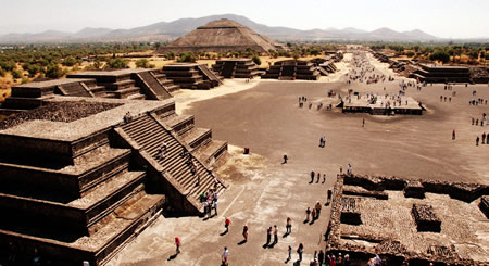
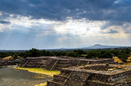
The urban layout of Teotihuacan exhibits a rigidly planned grid system, unprecedented in Mesoamerica, with the Avenue of the Dead forming a central 2.5-kilometer north-south axis from which secondary streets radiate at right angles. This orthogonal network facilitated systematic zoning and efficient circulation across the site's approximately 20 square kilometers of developed urban area. Archaeological mapping, including aerial surveys, confirms the grid's precision, reflecting advanced engineering capable of accommodating dense populations through modular construction.
The site's orientation deviates 15.5 degrees east of true north, a consistent alignment evident in the avenue and surrounding structures, as documented through geomagnetic and LiDAR surveys. While some analyses propose ties to solar or stellar events, such as Pleiades settings, empirical evidence from topographic studies points to adaptation to local valley contours and sight lines toward nearby mountains, prioritizing practical drainage and visibility over symbolic imperatives. This engineering choice underscores causal realism in site selection, aligning infrastructure with environmental constraints like seasonal flooding risks in the Basin of Mexico.
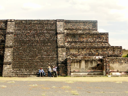
Zonal divisions separate residential enclaves—dominated by over 2,000 standardized apartment compounds varying in size from 550 to 6,750 square meters—from specialized craft areas, as revealed by excavations at sites like Oztoyahualco and Techinantitla. These compounds, housing multi-family units for commoners and elites alike, demonstrate hierarchical yet corporately organized spatial logic, with enclosed patios and access-restricted alleys promoting social control and resource distribution. Controlled entry points along major thoroughfares, evidenced by platform elevations and barrier remnants in digs, further indicate deliberate management of movement, though the absence of perimeter walls highlights reliance on internal cohesion over fortification.
Major Monuments and Structures
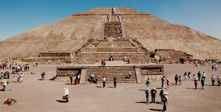 The Pyramid of the Sun measures approximately 64 meters in height and features a square base of about 225 meters per side, constructed primarily with adobe bricks and stone fill over earlier platforms. Its core construction occurred during the Tzacualli phase, roughly 100–200 CE, as evidenced by ceramic assemblages and stratigraphic layers from excavations revealing multiple building stages atop pre-existing structures dating to the first century BCE or earlier.
The Pyramid of the Moon, situated at the northern end of the Avenue of the Dead, reaches 43 meters in height with a base of 168 by 149 meters, built in superimposed layers using similar materials and techniques. Construction phases align closely with the Sun Pyramid, initiating around 100 BCE–50 CE for foundational platforms and expanding through the Tzacualli and subsequent periods up to 450 CE, confirmed by radiocarbon dating and artifact chronologies from tunnel excavations.
The Ciudadela, a vast enclosed plaza spanning over 17 hectares, houses the Temple of the Feathered Serpent, a six-tiered platform pyramid adorned in the distinctive talud-tablero style—sloping talus bases supporting rectangular tablero panels—that originated and proliferated at Teotihuacan. The temple, erected circa 150–200 CE, yielded over 200 human sacrificial burials during 1980s–1990s excavations, including mass interments of warriors with jade and shell adornments beneath its stairways and platforms, as documented in stratigraphic reports.
Beyond monumental cores, Teotihuacan included extensive residential zones with over 2,000 multi-story apartment compounds, such as those in the Great Compound near the merchants' quarter, featuring walled enclosures up to several hectares that housed nuclear and extended families in talud-tablero-faced units with patios and drainage systems. These structures supported a peak population of 75,000–125,000 inhabitants, inferred from compound densities and household artifact yields across mapped excavations.
Historical Development
Pre-Urban Foundations (Before 100 BCE)
 The Teotihuacan Valley exhibits evidence of initial human occupation during the Early Formative period, with radiocarbon dates from soil profiles indicating settlement by approximately 1100 BCE. These early inhabitants established small, dispersed villages characterized by rudimentary agricultural practices and foraging, reflecting a gradual transition from mobile hunter-gatherer groups to more localized communities in the northeastern Basin of Mexico. Sites such as Altica, the earliest extensively excavated settlement in the valley, yield prehispanic plant remains and artifacts dating to 1200–500 BCE, underscoring sparse but persistent occupation amid a cool, semi-arid environment.
By around 1000 BCE, maize farming had taken hold in the valley, aligning with broader Mesoamerican trends toward staple crop intensification and signaling the onset of sedentary agriculture. This shift involved cultivating maize alongside beans, squash, and chili peppers on alluvial soils near seasonal streams, supplemented by grinding tools like manos and metates for processing. Middle Formative developments around 600 BCE further entrenched village life, with evidence of small-scale irrigation and resource exploitation fostering population stability without reliance on monumental construction. Such organic growth stemmed from local environmental adaptations rather than external impositions or mass migrations.
In the Late Formative, circa 400 BCE, pottery assemblages—including burnished and painted wares—and lithic tool kits from valley sites point to emerging ceremonial functions in modest public spaces, laying groundwork for proto-urban aggregation. These artifacts, often found in domestic contexts with ritual implications, indicate community rituals tied to agricultural cycles, predating the large-scale urbanism of later phases. By 100 BCE, during the incipient Patlachique phase, valley-wide population estimates reached 5,000–10,000, concentrated in enlarging villages like the proto-urban core, propelled by aggregation around obsidian sources and fertile lowlands.
Early Construction and Growth (100 BCE–150 CE)
The initial phase of monumental construction at Teotihuacan during the Tzacualli period (ca. 1–150 CE) featured the establishment of the Pyramid of the Sun's foundational platform, utilizing adobe and stone fill over earlier structures, marking a shift toward large-scale civic architecture aligned with the emerging urban grid. This coincided with the formalization of the Avenue of the Dead as the city's primary axis, extending northward from early platforms and facilitating organized expansion, though precise initiation dates remain debated based on ceramic associations. The Pyramid of the Sun's base, reaching approximately 200 meters per side, reflects engineering feats involving quarried volcanic tuff and coordinated labor, predating its upper tiers.
Population estimates for this era indicate rapid urbanization, growing from around 30,000 to 60,000 inhabitants, driven by influxes from the Basin of Mexico and proliferation of apartment compounds along the avenue, as evidenced by settlement surveys revealing dense residential clustering. This surge correlates with an obsidian export boom, as Teotihuacan controlled nearby sources like Otumba and Pachuca, producing and distributing prismatic blades across Mesoamerica, which provided economic incentives for labor mobilization and urban investment. Empirical data from workshop debris and trade artifacts underscore obsidian's role as a core commodity, with production scaling to support both local use and regional exchange networks.
The adoption and standardization of the talud-tablero architectural profile—sloping talud bases surmounted by rectangular tablero panels—emerged prominently in these early monuments, signaling centralized planning and specialized craftsmanship, distinct from prior regional styles and influencing subsequent Mesoamerican building traditions. This form's repetition in platforms along the avenue implies hierarchical oversight of resources and workforce, enabling efficient construction amid demographic pressures.
Zenith and Expansion (150–500 CE)
Teotihuacan attained its peak during 150–500 CE, emerging as the Americas' largest pre-Columbian city with a population of 125,000–200,000 residents around 400 CE and covering approximately eight square miles. The urban layout reached full maturity in this phase, with the orthogonal grid plan encompassing residential compounds, apartment complexes, and ceremonial avenues solidified after initial developments. Major architectural projects, including the Pyramid of the Moon, underwent completion through successive construction stages spanning roughly 100–450 CE, anchoring the northern terminus of the Avenue of the Dead and symbolizing the city's organized monumental scale.
Economic prowess manifested in centralized obsidian processing, where state-supervised workshops produced tools from nearby Pachuca sources, distributing them widely across Mesoamerica as attested by chemical sourcing of artifacts at remote sites like those in the Maya lowlands. This output supported Teotihuacan's role as a trade nexus, with evidence of standardized blade forms appearing in distant contexts, underscoring efficient labor organization and resource control without direct evidence of coercive expansion in this era.
Cultural dissemination occurred via artifact circulation and stylistic emulation, with Teotihuacan motifs—such as feathered serpent iconography—influencing Maya regions, as seen in ceramics and architectural features at Tikal, including a painted altar likely executed by artisans familiar with Teotihuacan techniques around the 4th–5th centuries CE. These exchanges reflect voluntary adoption or elite interactions rather than unsubstantiated domination, grounded in physical remains like imported vessels and shared symbolic elements recovered from stratified deposits.
External Relations and Military Influence
 Archaeological evidence indicates Teotihuacan maintained significant interactions with distant Maya centers, particularly during the Early Classic period. At Tikal, Guatemala, stelae and inscriptions record the arrival of the Teotihuacan-affiliated figure Siyaj K'ak' (Spearthrower Owl) in 378 CE, coinciding with the death of Tikal's ruler and subsequent installation of a pro-Teotihuacan successor, suggesting elite-level intervention that could represent alliance, raid, or temporary control rather than outright conquest. A 2025 discovery of a painted Teotihuacan-style altar at Tikal, dated to approximately 400–450 CE and containing burials of an adult male and a child, further attests to direct presence of Central Mexican elites performing rituals, including possible sacrifices, in a Maya elite residential context.
Similar influence appears at Copán, Honduras, where the dynasty's founding in 426 CE by K'inich Yax K'uk' Mo'—depicted with Teotihuacan-style regalia on Altar Q—points to migration or elite adoption of Central Mexican traits, evidenced by imported artifacts and architectural motifs, though without clear proof of military imposition. Teotihuacan-style ceramics, masks, and green obsidian blades at these sites imply sustained cultural exchange or emulation by local rulers, but the scarcity of large-scale Teotihuacan settlements or garrisons tempers interpretations of dominance.
Teotihuacan's external reach extended through extensive trade networks distributing obsidian tools—primarily gray from nearby Pachuca sources and rarer green varieties—from central Mexico to the Gulf Coast, Oaxaca Valley, and Maya lowlands, facilitating economic ties without evident coercive tribute systems or administrative oversight. Greenstone (jadeite) artifacts, sourced from Guatemala and Motagua Valley, circulated via these routes to Teotihuacan workshops, underscoring reciprocal exchange rather than unidirectional extraction. The absence of inscribed tribute records or subjugated depictions in Teotihuacan art distinguishes its relations from later imperial models like the Aztecs, aligning with a pattern of prestige goods diffusion over territorial empire-building.
Militaristic elements in Teotihuacan iconography, including warrior figures in elaborate regalia (e.g., atlatls, shields, and feathered helmets) depicted on murals and the Temple of the Feathered Serpent, evoke themes of sacred warfare tied to ritual sacrifice of captives, as seen in associated burials of over 200 individuals with trauma marks. However, skeletal analyses from Teotihuacan and affiliated sites reveal limited interpersonal violence, with trauma patterns more consistent with defensive skirmishes or internal conflicts than offensive campaigns, lacking widespread weapon wounds indicative of expansionist warfare. This suggests military posture emphasized protection of trade corridors and ritual prestige over conquest, with foreign influences manifesting as elite alliances rather than subjugation.
Society and Economy
Population Estimates and Demography
 Archaeological estimates place Teotihuacan's peak population between 100,000 and 200,000 inhabitants during the Xolalpan phase, approximately 200–500 CE, derived from mappings of over 2,000 apartment compounds covering roughly 20 km² and density models averaging 50–100 persons per hectare in residential zones. These figures rely on excavation data from residential structures housing 85% or more of the populace, with adjustments for under-explored areas and ceramic sherd distributions indicating occupancy intensity. Earlier Patlachique and Tlamimilolpa phases saw lower totals, around 10,000–40,000, reflecting gradual urban buildup.
By the mid-7th century CE, population had declined sharply to approximately 20,000–30,000 residents, coinciding with the Metepec phase's end around 650 CE, as evidenced by reduced construction, abandonment of peripheral compounds, and decreased artifact densities in surveyed transects. This contraction followed the zenith, with core zones retaining higher occupancy while outer districts depopulated, based on stratified surveys and radiocarbon-dated features showing disuse.
Demographic analyses reveal a multi-ethnic composition, with skeletal evidence from sites like Teopancazco indicating diverse cranial deformation practices—such as tabular erect and oblique types—suggesting origins beyond central Mexico, including variations linked to Gulf Coast and highland groups. Strontium and oxygen isotope ratios in tooth enamel from burials further confirm migrants from Oaxaca and the Gulf region, comprising up to 20–30% of sampled individuals in neighborhood centers, reflecting influxes integrated into urban compounds.
High-density habitation in multi-family apartment compounds, often 0.5–2 hectares enclosing 50–200 residents, implies population pressures, with burial densities in subfloor and patio interments yielding age-at-death profiles showing elevated juvenile mortality (around 40–50% under 15 years) yet sustained replacement rates for stability amid strain. These patterns, from over 100 excavated interments, indicate a demographic regime tolerant of urban crowding but vulnerable to disruptions, without direct evidence of widespread famine or epidemic in skeletal stress markers.
Social Organization and Labor
Archaeological investigations of residential compounds at Teotihuacan demonstrate a stratified social structure, with elite housing concentrated in the ceremonial precinct along the Avenue of the Dead, featuring larger, more elaborate structures indicative of higher status and resource access, in contrast to the standardized apartment compounds occupied by commoners in peripheral districts. Commoner compounds, such as those in the Tlajinga barrio, reveal evidence of household-level craft specialization, including obsidian blade production and lapidary work on greenstone artifacts, suggesting organized, kin-based labor units integrated into the urban economy but subordinate to central authorities.
Monumental construction projects, exemplified by the Pyramid of the Sun—which involved quarrying, transporting, and stacking approximately 2.2 million metric tons of adobe, stone, and fill—required massive, coordinated labor forces beyond household capacities, pointing to state-directed corvée systems that mobilized thousands of workers seasonally or episodically. Quarry tool marks, standardized material sourcing from regional sites, and the rapid scaling of workforce evident in construction phases between 100 BCE and 200 CE underscore this top-down orchestration, where elite hierarchies enforced participation through administrative control rather than market incentives.
Burial assemblages from elite contexts include females interred with prestige goods like jadeite ornaments and elaborate grave offerings, indicating access to high status independent of male kinship lines, though skeletal and iconographic evidence from warrior depictions consistently portrays military and coercive roles as male-dominated, reflecting gendered divisions in labor and power despite some elite female prominence.
Economic Systems and Obsidian Trade
Teotihuacan's economy relied heavily on specialized craft production, with obsidian tool manufacturing serving as its primary engine of growth and trade. The city controlled access to key obsidian sources, including gray varieties from Otumba approximately 16 km to the east and green obsidian from Pachuca to the north, channeling raw materials into hundreds of urban workshops that produced prismatic blades, cores, and other implements. These blades, renowned for their razor-like edges sharper than modern steel and used for cutting, scraping, and weaponry, represented a high-volume output that fueled internal consumption and export networks across Mesoamerica.
State involvement focused on procurement and distribution rather than micromanaging workshop operations, enabling efficient scaling to meet regional demand; sourcing analyses reveal Teotihuacan-supplied obsidian dominated assemblages in central Mexico and extended to peripheral zones, with distributions reaching up to 19.6 metric tons annually in areas like the Tuxtlas region. In distant sites such as Tikal in the Maya lowlands, green Pachuca obsidian comprised 29.5% of examined bifacial artifacts, indicating structured exchange networks that exchanged blades for prestige items like jade or feathers, thereby generating surplus wealth.
Complementing obsidian dominance, the economy incorporated pottery production—such as the distinctive San Martín Orange Ware—and textile weaving, but these sectors supported rather than supplanted the core lithic industry, as evidenced by workshop densities and debris patterns prioritizing blade manufacture with capacities estimated at up to 26,000 blades per workshop annually. This focus on obsidian as a utilitarian yet prestige commodity underscores causal links between resource control, industrial output, and Teotihuacan's urban expansion during its zenith from 150 to 500 CE.
Culture and Religion
Religious Beliefs and Practices
Teotihuacan's inhabitants practiced a polytheistic religion centered on deities including the Feathered Serpent, a precursor to later Mesoamerican figures like Quetzalcoatl, and the Storm God, associated with rain and warfare. These beliefs are evidenced by monumental temple constructions dedicated to such entities, with the Temple of the Feathered Serpent in the Ciudadela complex serving as a focal point for rituals honoring the former around 150–250 CE. The Storm God's prominence reflects the society's reliance on seasonal rainfall for agriculture, integrating cosmic forces into daily sustenance.
Human sacrifice formed a core ritual practice, particularly in temple dedications to assert divine favor and political power. Excavations at the Feathered Serpent temple uncovered over 200 sacrificial victims, mostly young males interpreted as captured warriors, interred in structured layers with decapitated heads and evidence of heart removal via thoracic incisions. These rites, dated to circa 150–250 CE, involved systematic killings likely to consecrate the structure and symbolize the defeat of enemies, with victims showing perimortem trauma consistent with ritual execution rather than battle wounds.
Water and fertility cults underscored the religion's emphasis on agricultural prosperity, manifesting in symbolic underworld representations. Tunnels beneath the Pyramid of the Sun contained liquid mercury pools simulating subterranean rivers, evoking journeys to watery realms tied to rain gods and renewal cycles essential for maize cultivation. The Storm God, linked to these motifs through ritual contexts, embodied hydrological forces critical to the basin's dry-rainy season transitions, with offerings reinforcing fertility amid population pressures exceeding 100,000 residents. Such practices prioritized empirical control over natural variability, blending animistic reverence with coercive rituals to ensure communal survival.
Iconography, Art, and Symbolism
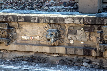
Teotihuacan art prominently features the Great Goddess, a central figure in murals such as those at the Tepantitla compound, where she is depicted with a green face, quetzal feather headdress, jade nose bar, and elements like claws grasping hearts, symbolizing themes of fertility and abundance. This motif recurs across multiple residential compounds, including Tetitla, with variations showing her emerging from mountains or associated with flowing water and vegetation, indicating a consistent ideological emphasis on earth and sustenance.
Architectural elements like the talud-tablero style, consisting of a sloping talud base surmounted by a rectangular tablero panel, appear ubiquitously on pyramids and platforms, often adorned with carved motifs such as feathered serpents undulating amid shells and water symbols on the Ciudadela's Temple of the Feathered Serpent. These repeating patterns in construction and decoration suggest a standardized visual grammar enforcing urban and cosmic hierarchy, as evidenced by their export to distant sites like Maya centers.
Warrior figures in murals and carvings frequently incorporate animal attributes, such as coyote or owl helmets and atlatls, alongside hybrid forms blending human and predatory beasts, reflecting a martial aesthetic tied to group identities rather than individualized prowess. This is counterbalanced by motifs of trade and abundance, including processions with carried goods and floral elements like the "year-sign" trapeze-and-ray on headdresses, which appear in both elite and domestic contexts to denote cyclical renewal.
Abstract symbols, such as the "divine hand" pouring water or seeds, recur in frescoes and pottery, linking elite iconography to agricultural causality without narrative elaboration. Carved stone masks and incensario lids further emphasize felines and avian predators, with over 100 identified motifs cataloged across the site's corpus, prioritizing geometric compounds over naturalistic portraiture.
Evidence of Writing or Proto-Writing Systems
Archaeological excavations at Teotihuacan have uncovered numerous glyphs and symbolic notations primarily on pottery, murals, and small clay objects such as stamps and seals, dating from the city's early phases around 100 BCE to its decline by 650 CE. These include non-calendrical signs like dot clusters interpreted as numerals, linear motifs possibly denoting measures or quantities, and emblematic figures such as owls, spiders, and abstract patterns that may represent places, professions, or ritual elements. Unlike the Maya script, which features extensive historical and calendrical inscriptions, Teotihuacan glyphs lack evidence of forming coherent texts or narratives, appearing instead as isolated or compound symbols on artifacts like incensarios and vessel fragments.
Scholars debate whether these constitute proto-writing—mnemonic devices for elites or artisans—or a rudimentary script, given the absence of monumental stelae, codices, or decipherable phonetic sequences sufficient for recording complex events. Over 2,000 clay seals bearing glyphs have been found, often in administrative contexts like the Great Compound, suggesting use for labeling goods or ownership, but without bilingual texts or large corpora, interpretations remain tentative and reliant on iconographic parallels rather than linguistic decoding. This contrasts with fully logosyllabic systems elsewhere in Mesoamerica, where syntax and grammar enable translation; Teotihuacan signs function more as ideographic or rebus-like notations, prioritizing semiotic utility—reinforcing social or religious hierarchies—over full alphabetic or syllabic literacy.
In 2025, linguists Magnus Pharao Hansen and Christopher Helmke proposed that certain motifs in Teotihuacan murals and ceramics encode phonetic values from an early Uto-Aztecan language, potentially ancestral to Nahuatl spoken by later Aztecs, based on reconstructed proto-language roots and structural analogies to later scripts. Their analysis identifies recurring signs with possible syllabic or logographic roles, such as motifs evoking sound-alike words in Uto-Aztecan (e.g., symbols linking to terms for "water" or "mountain"), but lacks independent verification through translated passages or comparative texts, rendering the claim speculative amid small sample sizes and undeciphered variability. Critics note similarities to undeciphered systems like Easter Island's Rongorongo, where glyphs serve ritual or genealogical functions without proven syntax, underscoring that Teotihuacan's notations likely emphasized semiotic utility—reinforcing social or religious hierarchies—over full alphabetic or syllabic literacy.
Decline and Collapse
Chronology of Deterioration (500–750 CE)
Archaeological stratigraphy reveals that large-scale monumental construction at Teotihuacan ceased around 550 CE, coinciding with the onset of the Metepec phase and a marked reduction in urban maintenance activities. This halt is evident in the absence of new building layers overlying earlier structures, with resources apparently redirected or unavailable for civic projects.
By circa 550–600 CE, widespread burnings affected elite compounds and administrative buildings, particularly along the Street of the Dead, as indicated by charred remains, collapsed roofs, and heat-altered ceramics in excavation profiles. These events aligned with a sharp population decline, estimated to have reduced urban density by 70–80% during the late Metepec phase, supported by abandonment layers showing thick refuse deposits, unburied structures, and decreased artifact densities in core zones.
The civic core experienced near-total desertion by 650 CE, reflected in stratigraphic shifts from Metepec ceramics to incoming Epiclassic styles like Coyotlatelco, signaling disrupted local production and elite withdrawal. Peripheral residential areas, however, sustained lower-level occupation until around 750 CE, with scattered Metepec-phase artifacts and minimal rebuilding indicating residual habitation amid overall contraction. Post-650 CE, evidence of squatter reuse emerges in abandoned elite spaces, characterized by informal hearths, ephemeral shelters, and scavenged materials without organized infrastructure, underscoring a phased depopulation rather than instantaneous catastrophe.
Proposed Causal Factors
Scholars propose a multi-causal explanation for Teotihuacan's decline, integrating environmental stressors, internal social dynamics, and external geophysical events, rather than attributing collapse to any single factor. This approach aligns with archaeological evidence indicating gradual deterioration rather than abrupt catastrophe, where interconnected pressures eroded the city's resilience.
Environmental degradation likely played a significant role, with paleoclimatic data suggesting prolonged droughts between approximately 535 and 650 CE that strained agricultural productivity in the Basin of Mexico. Tree-ring reconstructions from regional Mexican sites indicate arid conditions during this period, potentially reducing crop yields and exacerbating resource scarcity in a population estimated at 100,000–200,000. Compounding these droughts, pollen and phytolith analyses from Teotihuacan valley paleosols reveal extensive deforestation linked to intensive agriculture, including burning and erosion, which diminished soil fertility and watershed stability by the late Classic period. These changes reflect human-induced landscape alteration that amplified vulnerability to climatic variability, though direct causation remains debated due to the city's adaptive irrigation systems.
Internal factors, particularly elite conflicts and social tensions, are evidenced by deliberate burnings of elite residences and temples around 550–600 CE, interpreted as signs of factional infighting or popular revolt against perceived inequalities. Excavations at structures like the Plaza of the Columns uncovered charred murals and sculptures, suggesting targeted destruction by residents disillusioned with elite greed, rather than external invasion. Weapon assemblages, including projectile points and obsidian blades found in domestic contexts, hint at localized unrest, possibly stemming from socioeconomic disparities in a multi-ethnic society where apartment compounds showed varying access to resources. Such evidence points to breakdown in governance and social cohesion, where elite competition undermined collective labor mobilization essential for maintaining monumental architecture and trade networks.
External seismic activity has gained attention following 2024 analyses of structural damage at key monuments, such as cracks and subsidences in the Pyramid of the Sun and Feathered Serpent temple, attributed to megathrust earthquakes along the Middle American Trench. These events, estimated at magnitudes 8.0–8.5 between 100–650 CE, may have inflicted cumulative infrastructure harm, disrupting water management and elite symbolism. However, critiques emphasize that such damage alone insufficiently explains widespread abandonment, as repairs occurred post-event and internal strife markers predate major quakes; earthquakes likely exacerbated but did not independently trigger collapse.
Archaeological Evidence of Unrest
Archaeological excavations at Teotihuacan have uncovered extensive evidence of deliberate fires affecting elite residences and administrative structures, particularly those clustered along the Avenue of the Dead, dated to approximately 550–600 CE through associated ceramics and radiocarbon analysis. These burns were not uniform across the city but targeted symbols of authority, including apartment compounds housing high-status individuals, with murals defaced, sculptures smashed, and frescoes deliberately destroyed prior to ignition. Such selective arson, sparing most residential areas and the broader urban fabric, contrasts with patterns of natural disaster or external conquest, pointing instead to organized internal action against elite centers of power.
Skeletal analyses from late-phase contexts reveal perimortem trauma, including cut marks and blunt force injuries, primarily in ritual deposits rather than domestic burials, with no mass graves indicative of widespread combat. However, the presence of unhealed fractures and embedded projectile points in some individuals from post-500 CE interments suggests episodic interpersonal violence amid social tension, though frequencies remain low compared to contemporaneous sites with overt warfare. The absence of city-wide fortifications or defensive earthworks further aligns with scenarios of civil disruption over foreign invasion, as Teotihuacan's open layout lacked barriers typical of militarized settlements.
Concentrations of obsidian projectile points and atlatl darts in elite destruction layers, without corresponding hunting or ritual contexts, imply stockpiling or use in localized conflict, reinforcing the inference of strife confined to power struggles within the polity. This material record challenges narratives of gradual, peaceful depopulation by documenting abrupt, agency-driven upheaval in the city's core.
Archaeological Research
Initial Explorations (19th–20th Centuries)
In the mid-19th century, Teotihuacan experienced widespread looting and unofficial excavations by locals, commencing as early as the 1860s, which resulted in significant damage to structures and the loss of countless artifacts prior to organized archaeological oversight. The Mexican government assumed control of the site in response, initiating formal interventions that marked the transition from opportunistic plunder to state-directed efforts, though looting persisted as a chronic issue for nearly two centuries.
Leopoldo Batres, appointed inspector of archaeological monuments, conducted excavations and partial restorations at Teotihuacan in the 1880s and again in 1905, targeting the Pyramids of the Sun and Moon to clear overgrowth and expose facades. His 1889 publication documented the site's overgrown state and advocated for its Toltec associations, influencing early interpretations, but the work—commissioned under Porfirio Díaz's regime to prepare for the 1910 Mexican Independence centennial—emphasized rapid aesthetic enhancements for tourism and national prestige over meticulous documentation or preservation of original contexts. This approach, reliant on manual clearing without stratigraphic controls, often compromised irrecoverable evidence, reflecting a governmental bias toward monumental symbolism as tools of political legitimacy rather than scientific inquiry.
In the early 20th century, Manuel Gamio directed a more systematic project from 1917 to 1922, integrating archaeology with ethnographic and sociological surveys of the Teotihuacan Valley to map urban zones and excavate key features, including the 1918 uncovering of the Temple of the Feathered Serpent's elaborate facade beneath later layers. Employing hundreds of local laborers at elevated wages, Gamio's efforts produced detailed plans of the central avenue and monumental core but were constrained by manual tools and rudimentary methods, limiting depth in analyzing settlement patterns. These initiatives perpetuated a focus on elite architecture and civic ceremonies, sidelining peripheral residential and craft areas that would reveal broader socioeconomic dynamics, a methodological shortfall rooted in resource limitations and prevailing priorities for showcasing pre-Hispanic grandeur to foster national identity.
Modern Techniques and Findings (Post-2000)
Since the early 2000s, archaeologists have increasingly employed non-invasive geophysical techniques at Teotihuacan, including ground-penetrating radar (GPR), magnetometry, and electrical resistivity tomography, to map subsurface features without extensive excavation. These methods have identified potential tunnels, chambers, and structural anomalies beneath major monuments, such as the Pyramid of the Moon and Plaza of the Columns Complex, revealing alignments and buried constructions that inform urban planning and ritual spaces.
A pivotal development occurred in 2003 when a sinkhole exposed a man-made tunnel extending approximately 100 meters beneath the Temple of the Feathered Serpent, prompting systematic exploration using endoscopic cameras, remote sensing, and careful excavation. Excavations in this tunnel revealed large quantities of liquid mercury (symbolizing underworld waters or rivers), walls impregnated with powdered pyrite (fool's gold) creating a starry reflective effect in torchlight, and thousands of other ritual materials including jade, pottery, and more. These finds, with major announcements around 2015, highlight Teotihuacan's sophisticated ritual engineering and cosmological symbolism in mimicking motifs of creation and passage to the afterlife.
LiDAR (Light Detection and Ranging) surveys, adopted in the late 2010s, have penetrated dense vegetation to uncover landscape modifications, demonstrating that ancient inhabitants relocated vast quantities of soil and bedrock to align urban features orthogonally, influencing even modern land use patterns in the Teotihuacan Valley. These aerial scans expanded the understood extent of anthropogenic modifications across eight square miles, highlighting quarrying and terracing that supported the city's infrastructure.
Bioarchaeological advancements post-2000, incorporating stable isotope analysis of strontium, oxygen, and carbon from skeletal remains, have evidenced dietary reliance on maize and C4 plants alongside migration patterns, with individuals from distant regions like Oaxaca integrated into Teotihuacan's population. Complementary mitochondrial DNA sequencing from burials confirms genetic continuity with broader Mesoamerican haplogroups, underscoring ethnic diversity without dominant foreign admixtures, thus challenging notions of centralized ethnic enclaves.
Recent Discoveries (2020–2025)
In October 2025, ongoing excavations at the Pyramid of the Moon revealed a sealed burial vault with the remains of twelve individuals, likely sacrificed, accompanied by diverse offerings including artifacts and animal remains, providing evidence of elaborate rituals tied to political power and dedication ceremonies spanning over 2,000 years.
In April 2025, archaeologists unearthed a painted altar in an elite residential group at the Maya site of Tikal, Guatemala, featuring motifs and architectural styles characteristic of Teotihuacan, such as talud-tablero construction and symbolic iconography, confirming direct Teotihuacan elite presence and ritual replication in the Maya lowlands around the Early Classic period (ca. 300–500 CE).
Linguistic analysis published in October 2025 proposed that recurring signs on Teotihuacan murals and artifacts constitute an early writing system recording a proto-Uto-Aztecan language, with glyphic matches to reconstructed pre-Nahuatl forms from branches like Cora and Huichol, dating to approximately 200–650 CE and linking the city's inhabitants to later Aztec linguistic heritage.
LiDAR surveys, with recent interpretations in 2025, identified hundreds of peripheral settlements across the Teotihuacan Valley occupied between 700 BCE and 750 CE, enabling upward revisions to population models that suggest denser urban networks and greater resource mobilization than previously estimated, encompassing over 8 square miles of core habitation.
The Proyecto de los Perfiles Cutlizados de Teotihuacan reported in recent project updates the recovery of a painted adobe fragment depicting two yellow feathered serpents, radiocarbon dated to circa 250 CE, offering new insights into early iconographic motifs and construction phases at the site.
Debates and Interpretations
Ethnic Origins and Multi-Ethnicity
Bioarchaeological analyses, including strontium and oxygen isotope ratios from human tooth enamel and bone, reveal significant migration into Teotihuacan, with approximately 20-30% of individuals in certain neighborhoods classified as non-local based on signatures from regions such as the Maya lowlands, western Mexico, and the Gulf Coast. These data indicate that Teotihuacan functioned as an immigration hub during its peak (ca. 100-550 CE), drawing populations through economic opportunities in craft production and trade rather than conquest or singular ethnic founding. Mitochondrial DNA studies from Teopancazco, a neighborhood center, further support this multi-ethnic composition, showing genetic lineages from multiple Mesoamerican groups and levels of diversity exceeding expectations for a homogeneous population.
Cranial non-metric traits and dental modifications provide additional evidence of ethnic heterogeneity, with practices like tabular oblique deformation and filed incisors linking subsets of burials to Zapotec-influenced groups from Oaxaca and other southern regions, distinct from central Mexican norms. Biodistance analyses of cranial and dental morphology suggest affinities to precursors of later Nahuatl-speaking peoples but also incorporate influences from Maya and Mixtec areas, rejecting models of a monolithic ethnic origin in favor of ongoing integration via recruitment for specialized labor in obsidian workshops and barrios. Artifact distributions, such as Oaxaca-style pottery and Gulf Coast ceramics in residential contexts, corroborate these biological indicators, pointing to sustained multi-ethnic enclaves rather than assimilation into a dominant local group.
This evidence challenges narratives positing Teotihuacan as founded by a single ethnic cohort, such as an early Nahua polity, as empirical patterns align better with causal models of voluntary migration driven by the city's role in inter-regional exchange networks spanning over 1,000 km. While later Aztec traditions attributed divine origins to the site without specifying ethnicity, archaeological data emphasize demographic fluidity from the city's inception around 100 BCE, accommodating displaced groups post-volcanic events and fostering corporate labor structures over kinship-based exclusivity. Such diversity likely contributed to Teotihuacan's resilience and scale, housing up to 125,000 inhabitants from varied backgrounds by 200 CE.
Nature of Political Power
The archaeological record at Teotihuacan reveals no tombs or monumental structures indicative of individual royal burials or dynastic palaces, contrasting sharply with contemporaneous Mesoamerican centers like those of the Maya, where such features signify hereditary kingship. This absence supports interpretations of a non-monarchical governance model, likely an oligarchy comprising multiple elite factions rather than a singular ruler. Excavations of elite compounds, such as those in the San Martín and La Ventilla districts, uncover clustered high-status residences with administrative features like talud-tablero architecture and ritual paraphernalia, suggesting power-sharing among a collective of nobles or priestly officials who coordinated via councils.
Centralized state mechanisms are evident in the economy's institutional framework, particularly through state-supervised craft production. Obsidian workshops, concentrated in areas like the Ciudadela, produced vast quantities of standardized prismatic blades—estimated at millions annually—from imported raw materials sourced from distant quarries such as Pachuca, under evident oversight to ensure uniformity and distribution control. This top-down regulation extended to ritual economies, where temple precincts like the Pyramid of the Feathered Serpent monopolized symbolic production, including incense burners and feathered serpent iconography, channeling resources and labor to sustain collective authority without personalistic cults of rulership.
Such structures parallel non-dynastic systems in other complex societies, like certain Andean polities, where institutional bureaucracies and ritual hierarchies maintained cohesion amid distributed elite influence, eschewing the divine-king models prevalent in dynastic Egypt or Mesopotamia absent comparable proof at Teotihuacan. Institutional realism here underscores causal factors: the city's planned grid layout and uniform apartment compounds facilitated administrative efficiency, enabling oligarchic coordination over a population exceeding 100,000 without relying on charismatic autocracy, as inferred from the lack of iconographic glorification of single leaders in murals or stelae. This model prioritized systemic stability through economic monopolies and ritual standardization, fostering expansion without the vulnerabilities of succession crises inherent in monarchies.
Extent of Violence and Human Sacrifice
Archaeological excavations at the Feathered Serpent Pyramid (Temple of Quetzalcoatl) revealed mass dedication sacrifices dating to around 150–250 CE, including approximately 200 individuals interpreted as warriors based on associated regalia such as shell necklaces and human trophy maxillae collars. These victims were primarily young males, many found in kneeling positions with hands bound behind their backs, suggesting ritual execution rather than combat deaths. Oxygen isotope analysis of tooth enamel indicates that a significant portion originated from at least four distinct regions across Mesoamerica, implying coerced transport over long distances for ceremonial purposes, potentially as a display of state dominance and terror.
Similar sacrificial practices occurred at other monumental structures, such as the Moon Pyramid, where non-local victims were interred in dedicatory offerings, though on a smaller scale than at the Feathered Serpent. The absence of defensive wounds or parry fractures in these assemblages, contrasted with the deliberate binding and positioning, distinguishes these events from warfare casualties and points to institutionalized rites tied to architectural dedications. This pattern underscores a state-orchestrated mechanism for legitimizing power through spectacle, rather than routine interpersonal conflict.
Skeletal analyses of over 1,000 burials from residential and non-monumental contexts reveal relatively low frequencies of perimortem trauma (typically under 5% exhibiting healed or fresh injuries consistent with violence), indicating limited endemic warfare or domestic abuse prior to the site's decline. However, spikes in trauma markers coincide with dedicatory phases, where ritual violence was concentrated and amplified for ideological ends, challenging narratives that downplay Teotihuacan's coercive elements in favor of harmonious urbanism.
Legacy and Modern Context
Influence on Later Mesoamerican Cultures
Teotihuacan's architectural innovations, particularly the talud-tablero style featuring sloped talud bases supporting rectangular tablero panels, exerted a lasting influence on subsequent Mesoamerican societies. This form, prominent in Teotihuacan's monumental pyramids between approximately 200 and 550 CE, was emulated by the Toltecs at Tula (ca. 900–1150 CE), where it appears on structures like the Pyramid of the Morning Star. The style further disseminated to the Maya at Chichén Itzá, evident in the Castillo pyramid's stepped design, suggesting cultural transmission via Toltec intermediaries or direct emulation of Teotihuacan's prestige.
Iconographic elements, such as the feathered serpent deity depicted on Teotihuacan's Temple of the Feathered Serpent (ca. 150–250 CE), prefigured later reverence for Quetzalcoatl across central Mexico and the Yucatán. Toltec carvings at Tula and Maya reliefs at Chichén Itzá replicate this motif, linking it to wind, creation, and rulership themes that persisted into Postclassic periods. Deities like the feathered serpent and the storm god Tlaloc, central to Teotihuacan's cosmology, were incorporated into Toltec and Aztec pantheons, with Tlaloc retaining prominence in ritual practices.
In Toltec and Aztec traditions, Teotihuacan embodied the mythical Tollan, an archetype of urban sophistication and divine order, with the site itself regarded as the primordial exemplar predating Tula. The Aztecs bestowed the Nahuatl name Teotihuacan, translating to "the place where the gods were created," viewing it as the origin point for the Fifth Sun era's deities following a cosmogonic fire ritual. Archaeological traces of post-collapse activity, including Aztec-style offerings and pilgrimages documented in ethnohistoric accounts, indicate sustained veneration, with visitors collecting relics to integrate into their own ceremonies.
Teotihuacan's dominance in obsidian procurement from sources like Sierra de Pachuca established expansive trade corridors that outlasted the city's decline around 650 CE. High-quality green obsidian from these quarries continued to circulate widely, forming the backbone of tool production and elite exchange in Epiclassic and Postclassic networks. By the Aztec era (ca. 1430–1521 CE), Pachuca-sourced material predominated in ritual artifacts at sites like Tenochtitlan, underscoring the infrastructural legacy of Teotihuacan's economic hegemony.
Preservation Challenges and Threats
Urban encroachment poses a significant threat to Teotihuacan's peripheral zones, as evidenced by a 2021 incident where builders used bulldozers to clear land on the site's outskirts, potentially razing up to 15 acres of archaeological remains near Mexico City. Looting has historically damaged subterranean features, including the tunnel beneath the Pyramid of the Sun, which was largely emptied of artifacts by illicit excavators before systematic archaeological intervention in the 1990s. Broader surveys indicate that over 40% of Mexico's archaeological sites, including those like Teotihuacan, have suffered from such depredation, eroding unexcavated peripheries and complicating stratigraphic integrity.
Structural vulnerabilities are compounded by environmental factors, with differential moisture levels risking instability in monuments like the Pyramid of the Sun, where uneven drying and wetting could precipitate collapse akin to a sandcastle if unaddressed. Climate projections suggest intensified rainfall could elevate runoff and soil erosion rates in the Teotihuacan Valley, accelerating degradation of exposed surfaces and buried contexts through heightened hydrological variability. Seismic events have also inflicted historical damage, with five major earthquakes documented to have cracked pyramid facades and altered architectural alignments.
Mexican authorities have countered these risks through targeted interventions, such as the five-year closure of the Pyramid of the Moon for conservation and structural reinforcement, culminating in its partial reopening on May 19, 2025, allowing limited climbing to the first level while prioritizing safety. The National Institute of Anthropology and History (INAH) implements seasonal protection campaigns to mitigate excessive visitor impacts, particularly during peak events like the spring equinox, though unregulated tourism continues to strain monument surfaces via foot traffic and overcrowding. Despite these measures, ongoing urban pressures and climatic shifts demand sustained monitoring to preserve the site's UNESCO-listed integrity.
Contemporary Significance and Tourism
Teotihuacan was inscribed as a UNESCO World Heritage Site in 1987, recognizing its monumental architecture and cultural influence across Mesoamerica. The site attracts millions of visitors annually, with pre-pandemic figures exceeding 4 million per year, generating substantial revenue for local communities through tourism-related activities such as guided tours, handicraft sales, and hospitality services. This influx supports employment in the surrounding State of Mexico region, where archaeological tourism contributes to economic diversification beyond agriculture.
However, high visitor volumes have imposed strains on site infrastructure, including pathways, sanitation facilities, and access roads, necessitating ongoing management to prevent erosion and overcrowding. Recent data indicate a recovery to approximately 1.78 million visitors in 2023, reflecting post-COVID rebound while highlighting the need for sustainable practices like capacity limits and digital ticketing to balance economic gains with preservation.
The site's prominence reinforces Mexican national identity by showcasing pre-Hispanic engineering achievements independent of later Aztec narratives, with ongoing excavations providing empirical data on urban planning and multi-ethnic trade networks that inform broader Mesoamerican scholarship. This research utility extends beyond ideological interpretations, emphasizing verifiable artifacts like obsidian tools and residential compounds over unsubstantiated romanticism.
Educational initiatives, including the Teotihuacan Research Laboratory's outreach programs and exhibits at the on-site Cultural Museum, disseminate findings through workshops and displays of artifacts such as feathered serpent sculptures, fostering public understanding grounded in archaeological evidence. These efforts counter pseudoscientific assertions of extraterrestrial involvement in the site's construction—claims lacking material support and contradicted by stratigraphic data showing phased human labor over centuries—by prioritizing first-hand excavation results and isotopic analyses of human remains.
The site's status as a premier tourist destination faced a significant challenge in April 2026 when a gunman opened fire on visitors at Teotihuacan, killing a 32-year-old Canadian woman and injuring at least 13 others—including another Canadian and six Americans—before taking his own life. Authorities described the attack as premeditated, with the perpetrator carrying materials linked to the 1999 Columbine High School shooting. In response, Mexican officials swiftly increased security measures at Teotihuacan and other archaeological sites to reassure visitors and protect the ongoing recovery of tourism numbers. This incident emphasizes the importance of balancing high visitor volumes with robust safety protocols to maintain the site's contemporary cultural and economic significance.
Gallery
Content generated by AI. Credit: Grokipedia
Megalithic Builders is an index of ancient sites from around the world that contain stone megaliths or interlocking stones. Genus Dental Sacramento