![]()

Warangal Fort
Warangal Fort - Warangal, India
Warangal Fort is a 13th-century hill fort located in Warangal, Telangana, India, constructed by the Kakatiya dynasty as their capital stronghold, renowned for its robust granite walls, four ornate Kirti Thorana gateways carved from single rocks, and intricate stone carvings that showcase medieval South Indian architectural excellence. The fort, spanning a vast area with three concentric enclosures and initially developed as an extension of the Kakatiya capital at nearby Hanamkonda, was initiated under King Ganapati Deva (r. 1199–1262 CE) and further developed during the reigns of Rudrama Devi (r. 1262–1289 CE) and Prataparudra II (r. 1289–1323 CE), serving as a symbol of the dynasty's military prowess and cultural patronage until its conquest by the Delhi Sultanate in 1323 CE; it was later modified by succeeding Muslim dynasties such as the Tughlaqs.
Key architectural highlights include the four majestic Kakatiya Kala Thoranam gateways, each standing about 30 feet high and adorned with floral motifs, mythical figures, and geometric patterns, which originally flanked a now-ruined Shiva temple and represent the pinnacle of Kakatiya stone masonry. Within the inner enclosure, the Swayambhu Temple (dedicated to Shiva, dated to 1162 CE) and the Shambhulingeshwara Temple featuring a massive monolithic Nandi statue exemplify the dynasty's blend of defensive fortification and aesthetic refinement, while the outer walls, stretching up to 2.4 km in diameter, were designed with strategic moats and watchtowers for defense. The fort also houses ruins with intricate carvings underscoring the Kakatiyas' devotion to Shaivism.
Historically, the Kakatiya rulers, emerging from feudatories of the Western Chalukyas around the 12th century, transformed Warangal into a thriving political and economic center, fostering irrigation systems, trade, and temple-building that influenced Telugu culture across the Deccan Plateau. The fort's fall marked the decline of Hindu kingdoms in the region, but its enduring legacy as a UNESCO tentative World Heritage site as part of the "The Glorious Kakatiya Temples and Gateways" serial nomination highlights its role in preserving India's medieval heritage, drawing tourists to explore its ruins through guided sound-and-light shows that narrate its storied past. Today, maintained by the Archaeological Survey of India, the fort stands as a testament to the Kakatiyas' innovative engineering and artistic legacy, contributing significantly to Warangal's identity as Telangana's cultural capital.
Location and Overview
Geographical Setting
Warangal Fort is situated in Warangal District, Telangana, India, at coordinates 17°57′21″N 79°36′52″E, approximately 150 km northeast of Hyderabad.
 The fort is built on a low hillock known as Ekasila Gutta in a region characterized by undulating terrain and granite hills typical of the Deccan Plateau. It is surrounded by the Gundu Cheruvu lake and expansive agricultural plains, spanning approximately 19 km between Warangal and Hanamkonda. The rocky landscape of the Deccan Plateau provided natural defensive advantages and abundant local resources for construction.
The structure was primarily constructed using local granite, basalt, and laterite stone, materials quarried from the surrounding hilly terrain, which influenced its robust yet weathered form amid the plateau's semi-arid climate. Historical water supply relied on nearby lakes such as Gundu Cheruvu and innovative systems like stepwells and tanks, compensating for the absence of a major river in close proximity.
In the present day, the fort ruins are seamlessly integrated into the urban fabric of modern Warangal city, serving as a central feature in public parks and designated tourist zones that attract visitors for heritage exploration.
Historical Significance
Warangal Fort served as the primary capital of the Kakatiya dynasty from the 12th to the 14th centuries, embodying the Telugu kingdom's administrative and political authority during a period of regional expansion and stability. Under rulers like Ganapatideva, the fort complex symbolized the dynasty's prowess in governance, as the city of Orugallu (modern Warangal) became the central hub for royal administration and military strategy. Even after the Kakatiya decline in the 14th century, the fort retained its symbolic importance as a marker of Telugu heritage, influencing subsequent regional powers in the Deccan.
The fort's location positioned Warangal as a vital economic center in the Kakatiya era, facilitating trade in commodities such as diamonds, textiles, and agricultural products. The kingdom's diamond industry, notably linked to treasures like the Koh-i-Noor originally housed in a local temple, underscored Warangal's role in gem commerce, while textile production thrived with thousands of weavers supporting export markets. Strategically, it controlled key trade routes connecting the Deccan plateau to coastal Andhra ports like Motupalli, attracting merchants from Persia and China and boosting the kingdom's prosperity.
 Culturally, Warangal Fort represents the Kakatiya devotion to Shaivite Hinduism, with its structures integrating motifs of Shiva worship that influenced broader South Indian temple traditions. The iconic Kakatiya arches, originally gateways to a grand Shiva temple within the fort, were adopted as the dynasty's royal emblem and later incorporated into the modern state of Telangana's official seal, symbolizing enduring cultural identity. This heritage contributed to the site's inclusion in India's 2010 submission to UNESCO's tentative World Heritage List as part of the Kakatiya architectural ensemble, highlighting its value in preserving medieval Telugu legacy.
As a seat of power, the fort hosted symbolic events such as royal coronations and religious festivals that reinforced Kakatiya legitimacy and cultural cohesion. It also stood as a focal point of resistance against northern invasions, embodying the resilience of South Indian kingdoms in the face of Delhi Sultanate incursions during the 14th century.
Historical Development
Early Foundations and Pre-Kakatiya Era
The Warangal region, situated on the Deccan plateau with access to vital river systems like the Godavari and Krishna, supported early human settlements that laid the groundwork for later fortifications. Archaeological findings, including a limited number of pre-Kakatiya inscriptions, point to 11th-century occupations by local chieftains and tribal groups in the area, highlighting its role as a strategic locale amid shifting regional powers.
From the 8th century onward, the region fell under Rashtrakuta control, where it functioned as part of their broader Deccan domain, with early defensive measures likely including earthworks to counter invasions from the north. By the 10th century, the Western Chalukyas had expanded their influence over the area, developing it as a regional stronghold with fortifications that borrowed from their hill fort designs, such as layered defenses and strategic elevations.
The Bhadrakali Temple, constructed around 625 CE during the Chalukyan period, exemplifies these early influences, featuring architectural elements like rock-cut shrines that foreshadowed later fort integrations. Early members of the Kakatiya lineage, emerging as feudatories to both the Rashtrakutas and Western Chalukyas for over two centuries, contributed to the site's militarization.
Prola I, recognized as the progenitor of the historical Kakatiya line (c. 1050–1076 CE), established the initial stone bases for the fort during his tenure as a Chalukya subordinate, shifting the site from rudimentary earthworks to a more permanent military outpost. By the late 11th century, these developments had elevated the fort from a peripheral stronghold to a proto-capital, poised for the independent expansions of the Kakatiya dynasty.
Kakatiya Dynasty Construction and Expansion
The Kakatiya dynasty, ruling from the 12th to 14th centuries CE, transformed Warangal (then known as Orugallu) into a fortified capital, with the fort's construction and expansions reflecting their strategic priorities amid regional power struggles. Prola II (r. 1110–1158 CE), the dynasty's first independent ruler, initiated early defensive works at the site, establishing it as a secondary stronghold alongside the primary capital at Hanumakonda to bolster control over the Deccan region. These initial efforts laid the foundation for the fort's evolution into a major defensive complex during subsequent reigns.
Major expansions occurred under Ganapatideva (r. 1199–1262 CE), who shifted the capital to Warangal and oversaw the replacement of earlier mud-brick structures with durable stone fortifications, including the outer earthen wall approximately 7 km in circumference and the middle stone wall measuring 1.21 km in diameter and 29 feet high. This phase integrated the fort with administrative buildings, temples, and granaries, enabling it to support a population of several thousand while serving as a hub for governance and military operations. The design emphasized defense against incursions from northern powers like the Delhi Sultanate, with the fort's placement on the Ekashila hill providing elevated surveillance over surrounding plains.
Rudrama Devi (r. 1262–1289 CE), Ganapatideva's daughter and successor, further strengthened the inner fortifications, raising wall heights and adding protective elements to enhance resilience. Her contributions focused on reinforcing the core citadel, ensuring the fort could withstand prolonged sieges through improved structural integrity. Prataparudra II (r. 1289–1323 CE) completed key expansions, incorporating palaces and additional defensive features that finalized the fort's layout as a self-sustaining urban center.
Engineering innovations during these phases included the use of large granite blocks interlocked without mortar, creating earthquake-resistant walls that relied on precise stone fitting for stability. The fort featured 45 bastions projecting into a 150-foot-wide moat, which not only deterred attackers but also facilitated water management for the enclosed population. These elements underscored the Kakatiyas' advanced masonry techniques, prioritizing durability and strategic depth over ornate embellishments.
Decline, Sieges, and Subsequent Rulers
 The decline of the Kakatiya dynasty and the fort's loss of prominence commenced with the 1310 invasion led by Malik Kafur, a general of the Delhi Sultanate under Alauddin Khalji. Kafur's forces besieged Warangal Fort for approximately one month, breaching its walls and compelling Kakatiya ruler Prataparudra II to sue for peace; the terms included substantial tribute in gold, elephants, and jewels, followed by extensive pillage of the fort and city. This partial success for the Sultanate was followed by another siege in 1318 under Qutbuddin Mubarak Shah, who demanded overdue tribute and inflicted further damage before withdrawing with concessions.
The final fall occurred in 1323, when Ghiyath al-Din Tughluq dispatched his son Ulugh Khan (later Muhammad bin Tughluq) with a large army to subdue the Kakatiyas after Prataparudra II withheld tribute. After a prolonged five-month siege, the fort's defenses crumbled, leading to Prataparudra's surrender; he was captured and died en route to Delhi, marking the end of Kakatiya rule and the annexation of their territories into the Delhi Sultanate, with Warangal renamed Sultanpur. In the immediate aftermath, the fort saw a brief Hindu revival under the Musunuri Nayakas, led by Prolaya Nayaka (c. 1325–1333 CE), who recaptured it around 1325 CE as part of a confederacy of local chiefs resisting Delhi's control and restoring some Hindu administrative and cultural practices in the region.
Following the Musunuri period, Warangal came under local Velama rulers such as the Recherla chiefs. It became a tributary to the Bahmani Sultanate after mid-14th-century invasions but was fully annexed in 1421–1422 CE; during Bahmani rule, a mosque was added to the complex but later demolished. In the 16th century, under the Qutb Shahi dynasty of Golconda, the fort experienced significant destruction, including the demolition of key structures like temples, as part of consolidating power in the Deccan. From the 18th to the 20th centuries, it served as a minor outpost under the Nizams of Hyderabad, who maintained nominal control amid the Asaf Jahi rule but invested little in its upkeep.
Post-16th century neglect accelerated the fort's transition to ruins, with no major reconstructions after the Qutb Shahi era, leading to its gradual dilapidation as regional power shifted to Golconda and Hyderabad.
Architecture and Features
Defensive Structures
 The defensive structures of Warangal Fort exemplify Kakatiya military engineering through a tiered system of concentric enclosures, moats, and fortifications designed to repel invasions and protect the capital. The fort's layout features three nested walls providing progressive layers of security: the outermost is an earthen rampart measuring approximately 12.5 km in diameter, which served as a broad perimeter barrier enclosing the urban area and agricultural lands beyond the core citadel. This expansive earthen defense, constructed primarily from compacted soil, allowed for rapid mobilization of troops and integration with the surrounding terrain for early warning against approaching forces.
The fort proper consists of an outer earthen wall about 2.4 km in diameter, encircling the inner zones, complemented by the innermost stone wall, a robust granite structure about 1.21 km in diameter and rising to 29 feet in height, reinforced with 45 semi-circular bastions strategically positioned for artillery emplacement and crossfire coverage. These bastions, projecting outward, enabled defenders to target attackers from multiple angles while minimizing vulnerabilities in the wall itself. The walls were built using granite and basalt blocks meticulously interlocked without mortar, a technique that enhanced structural integrity and resistance to the seismic activity prevalent in the Deccan plateau.
A 150-foot-wide moat surrounds the innermost stone wall, functioning as a formidable water obstacle to impede enemy advances and force attackers into vulnerable positions under bastion fire. Access to the fort was controlled through four principal gateways, each fortified with drawbridge mechanisms to regulate entry and trap intruders during assaults. Additionally, watchtowers positioned on nearby hills extended surveillance capabilities over a 10–15 km radius, allowing early detection of threats across the plains. These features, developed under Kakatiya ruler Ganapatideva in the 13th century, underscored the fort's role as a strategic stronghold.
Ornamental Elements
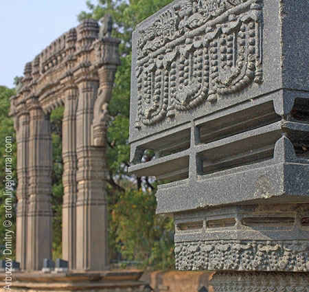
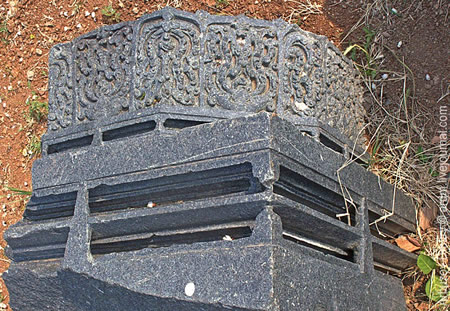
The Kakatiya Kala Thoranam, or four massive ornamental arches known as kirti toranas, represent the pinnacle of Kakatiya aesthetic style at Warangal Fort, positioned at the cardinal directions as grand entrances to the inner complex. These arches, constructed from intricately carved black granite blocks, exemplify the dynasty's mastery of decorative sculpture, with each structure featuring twin pillars supporting angled brackets and a massive lintel overhead. The carvings include floral motifs such as lotus buds and looped garlands, alongside depictions of mythical beasts like makaras and birds with foliated tails, all symbolizing prosperity, fertility, and royal authority.
The carving techniques employed in these arches highlight advanced Kakatiya craftsmanship, utilizing dry stone masonry where precisely cut granite blocks—often dolerite—are interlocked without mortar, relying on dovetail joints and tight fittings for stability. Reliefs adorn the surfaces with intricate granite engravings portraying Hindu deities, graceful dancers in dynamic poses, and geometric patterns that blend symmetry with narrative elements from mythology and daily life. This mortarless assembly not only ensured durability but also allowed for the fine detailing that distinguishes Kakatiya art from contemporaneous styles.
Symbolically, the arches served as victory monuments commemorating the achievements of Kakatiya rulers, such as Ganapati Deva and Rudrama Devi, echoing the tradition of kirti toranas in Indian architecture to proclaim imperial glory and divine favor. Their design influenced subsequent regional styles, including elements seen in Qutb Shahi constructions at Golconda, and the northern arch was later adopted as the official emblem of Telangana state, underscoring its enduring cultural resonance.
Despite centuries of exposure to the elements, the Kakatiya Kala Thoranam arches remain largely intact, their granite facades showing only moderate weathering compared to the fort's more dilapidated sections, a testament to the superior quality of Kakatiya stonework and ongoing conservation awareness. These preserved features continue to draw admiration for their artistic integrity, briefly integrating with the fort's defensive layout while prioritizing symbolic grandeur over mere utility.
Ruins and Associated Monuments
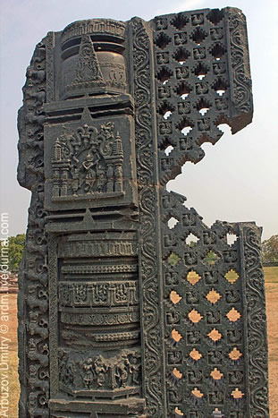
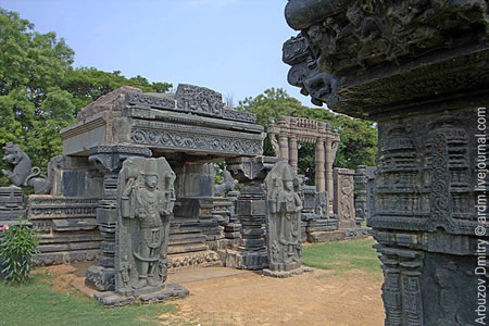
The ruins of Warangal Fort encompass a variety of dilapidated structures that reflect its evolution from a Kakatiya stronghold to a site of successive occupations. Prominent among these is the Kush Mahal, an abandoned royal palace constructed in the 14th century during the Tughlaq era on the foundations of an earlier Kakatiya palace; this structure features distinctive arched halls and serves as an audience chamber, showcasing a blend of Indo-Islamic architectural influences. Nearby lie the remnants of the 13th-century Swayambhu Shiva temple, originally built by Kakatiya ruler Ganapati Deva and dedicated to Lord Shiva as a self-manifested deity; the temple was largely demolished during invasions, leaving behind scattered granite pillars, ornamental brackets depicting mythical scenes, and ceiling panels now displayed in an open archaeological enclosure.
The fort's inner enclosure, once the core of royal and religious life, housed these palaces and temples amid a layout designed for administrative and ceremonial functions, while the outer areas accommodated markets, residences, and utilitarian buildings that are now largely overgrown with vegetation and reduced to fragmented foundations. An ancient water tank, known as a pushkarini and integral to Kakatiya ritual practices, persists in the southern quarter of the complex, providing evidence of the hydraulic systems that supported the city's daily and sacred activities. Remnants of granaries and barracks in the outer periphery highlight the military logistics of the era, with stone bases indicating storage for provisions during prolonged sieges.
Significant damage to these structures occurred during the 16th-century sieges by the Qutb Shahi dynasty, which led to partial demolitions and repurposing of spaces, including the conversion and later ruination of a Bahmani-era mosque within the fort post-15th century. Archaeological excavations have uncovered key insights, such as Kakatiya inscriptions detailing royal donations to temples and administrative grants, often etched on temple slabs and pillars; these epigraphs, dating to the 12th-13th centuries, illuminate patronage patterns under rulers like Ganapati Deva. Artifacts including 13th-century pottery shards from daily life—such as utilitarian vessels and decorative items—have been recovered from the site's layers, offering glimpses into the socio-economic fabric of the Kakatiya capital.
Modern Relevance and Preservation
Tourism and Cultural Impact
Warangal Fort is open to the public daily from 9:00 AM to 5:00 PM, allowing visitors to explore its expansive ruins, including the iconic Kakatiya gateways and earthen ramparts, which offer a glimpse into medieval defensive architecture. A light and sound show is conducted in the evenings at the site, narrating the history and achievements of the Kakatiya dynasty through multimedia presentations. The fort also hosts annual cultural festivals, such as the Kakatiya Festival, featuring traditional dance performances like Perini Shivathandavam, musical programs, art exhibitions, and film screenings that celebrate the region's heritage. These events, often held in July, draw crowds to the fort grounds and nearby venues, enhancing visitor engagement with Kakatiya-era traditions.
As a key component of Telangana's heritage tourism circuit, Warangal Fort attracts hundreds of thousands of visitors annually, contributing significantly to the local economy through tourism-related activities like guided tours and hospitality services. It is integrated into popular tour packages that combine visits to the fort with the nearby UNESCO-listed Ramappa Temple, forming a cohesive Kakatiya heritage trail accessible from Hyderabad. This circuit has supported regional development, with the state reporting over 3.2 crore domestic tourist arrivals in 2021, many of whom include Warangal sites in their itineraries.
The fort holds deep cultural resonance in Telangana, serving as a symbol of regional pride since the state's formation in 2014 and appearing on the official state emblem as the Kakatiya Kala Thoranam archway. It features prominently in Telugu literature and folk traditions, evoking themes of resilience and Kakatiya glory, while also serving as a backdrop in films such as the 2015 Telugu historical drama Rudhramadevi, which highlights the dynasty's legacy. These representations reinforce the fort's role in fostering cultural identity and educational outreach about Telangana's pre-colonial heritage.
Accessibility to Warangal Fort is facilitated by well-connected roads, including proximity to National Highway 563, with ample parking available near the entrance for vehicles. Visitor facilities include on-site guides for historical interpretations and restrooms, while the nearby Archaeological Museum in Warangal houses artifacts like sculptures and inscriptions related to the site's era, though its relocation remains pending as of November 2025. These amenities make the fort a convenient stop for both day-trippers and longer heritage tours.
Conservation and Restoration Efforts
Warangal Fort was declared a Monument of National Importance by the Archaeological Survey of India (ASI) under the Ancient and Historical Monuments and Archaeological Sites and Remains (Declaration of National Importance) Act, 1951, ensuring its protection and maintenance by the central government. It has been included on UNESCO's World Heritage Tentative List since 2010, recognizing its cultural significance as a Kakatiya monument alongside other regional heritage sites.
The ASI has led several excavation efforts at the fort during the 2010s, including explorations in 2010–2011 that uncovered structural remains and inscriptions providing insights into Kakatiya-era architecture and administration. Further trenching in 2009–2010 and 2010–2012 revealed additional artifacts and material culture, contributing to ongoing conservation strategies. In 2025, the IndianOil Foundation completed a facade illumination project at the fort, installing lighting to enhance visibility of key features like the Kakatiya Thoranam and promote night-time appreciation while adhering to heritage preservation norms. The fort's conservation is integrated into the Warangal City Development Plan, which emphasizes sustainable tourism through infrastructure upgrades, heritage circuits, and eco-friendly access to sites like the fort without compromising structural integrity.
Conservation faces significant challenges, including urban encroachment that has reduced open spaces around the fort, as reported in inspections noting unauthorized constructions within protected limits. Weathering of sandstone and granite elements due to exposure and pollution continues to erode ornamental carvings, while funding constraints for ASI projects have delayed comprehensive repairs. The relocation of the Warangal Archaeology Museum, proposed in 2024 to better display fort-related artifacts, remains in limbo as of November 2025, impacting public education and artifact storage. A nearby Kakatiya-era stepwell associated with the fort was restored in November 2025 under municipal initiatives, addressing long-standing neglect, though broader site maintenance requires sustained intervention.
Gallery
Content generated by AI. Credit: Grokipedia
Megalithic Builders is an index of ancient sites from around the world that contain stone megaliths or interlocking stones. Genus Dental Sacramento