![]()

Tikal
Tikal - Flores, Guatemala
Tikal is an ancient Maya city and one of the most significant archaeological sites of the pre-Columbian era, located in the Petén Department of northern Guatemala within Tikal National Park. Inhabited from approximately the 6th century BC to the 10th century AD, it emerged as a major political, economic, and military center during the Classic Period (c. 250–900 CE), when it dominated much of the southern Maya lowlands as the capital of a powerful kingdom.
At its peak in the Late Classic Period (c. 600–900 CE), Tikal supported a population estimated at 45,000–100,000 inhabitants, with the urban core possibly sustaining around 55,000, supported by advanced agriculture, trade networks, and water management systems. The city's decline began in the late 9th century CE, coinciding with broader disruptions in the Maya world, including warfare, environmental stress, and resource depletion, leading to its abandonment by the early 10th century.
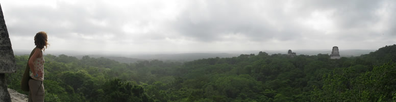
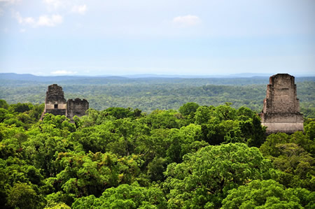
Tikal is renowned for its monumental architecture, including over 3,000 structures such as towering temples, palaces, and ballcourts, many constructed from limestone and featuring intricate stucco masks and hieroglyphic inscriptions recording royal dynasties and events. Key features include the Great Plaza, flanked by Temple I (the Temple of the Great Jaguar, 47 meters tall) and Temple II, and the North Acropolis, a massive complex of over 100 temples and elite residences built and rebuilt from the Preclassic to Classic periods. Temple IV, completed around 741 CE, rises to approximately 65 meters (212 feet), making it one of the tallest pre-Columbian structures in the Americas and a testament to Maya engineering prowess. Recognized as a UNESCO World Heritage Site since 1979, Tikal exemplifies the cultural, artistic, and scientific achievements of the Maya, including advancements in astronomy, mathematics, and hieroglyphic writing.
Name and Location
Etymology
The name Tikal derives from the Yucatec Maya phrase ti ak'al, meaning "at the waterhole," a reference to the artificial reservoirs that sustained the ancient settlement in the seasonally dry Petén region of Guatemala. An alternative interpretation suggests it comes from the Itza Maya language, meaning "place of voices" or "place of languages." This designation likely originated among later Maya speakers or 19th-century explorers who encountered the site's water features, rather than reflecting the city's original nomenclature.
In contrast, hieroglyphic inscriptions from the Classic period identify the polity as Yax Mutul (or Yax Mutal), translating to "First Mutul," where Mutul served as the emblem glyph denoting the dynastic seat and surrounding territory. The prefix yax ("first" or "green") emphasized its primacy among related centers bearing the Mutul title, underscoring Tikal's role as the foundational capital of this influential lineage.
Following the Spanish conquest, the site faded from widespread knowledge, with the name Tikal gradually reemerging in archaeological records during the 19th and 20th centuries as excavations revealed its extent; modern scholars adopted it for convenience, while prioritizing Yax Mutul in epigraphic analyses to honor the ancient self-reference.
Geography
Tikal is situated in the northern part of Guatemala's Petén Department, within the boundaries of Tikal National Park, a protected area encompassing approximately 576 square kilometers of lowland tropical rainforest known as the Maya Forest. Designated a UNESCO World Heritage Site in 1979 for its cultural and natural significance, the park safeguards the ancient Maya city amid a landscape that extends into neighboring Mexico and Belize. The site's central coordinates are approximately 17°13′14″N 89°37′29″W, placing it in a remote region accessible primarily by air or road from the nearby town of Flores.
The geography of Tikal features a karst topography characterized by porous limestone bedrock from the Cretaceous period, which forms the underlying structure of the Petén Basin and contributes to subsurface drainage patterns typical of the area. This karst landscape, with its sinkholes, caves, and low-lying hills, sits at an average elevation of around 300 meters above sea level, though the terrain varies from 185 to 400 meters across the park. Surrounding the archaeological core is a dense canopy of tropical broadleaf evergreen forest, dominated by species such as mahogany and ceiba trees, which thrive in the humid, seasonal climate with annual rainfall exceeding 1,500 millimeters.
Tikal lies in close proximity to other significant Maya sites, including Uaxactún, located about 20 kilometers to the north, which served as an early ceremonial center in the region. Further north, in May 2025, archaeologists uncovered the Los Abuelos complex—a Preclassic ritual center spanning three interconnected cities (Los Abuelos, Petnal, and Cambrayal) with pyramids, plazas, and canal systems—approximately 21 kilometers from Uaxactún, highlighting the dense network of ancient settlements in the northern Petén lowlands.
Historical Overview
Preclassic Period
 The Preclassic Period at Tikal spans from approximately 1000 BCE to 250 CE, marking the site's emergence as a significant Maya center in the Petén region of Guatemala. The earliest evidence of human occupation dates to around 1000 BCE during the Early Preclassic, indicated by environmental DNA analysis from soil samples that reveal arboreal modifications and human activity consistent with initial settlement. These early inhabitants likely formed small villages focused on maize cultivation and basic resource exploitation, as supported by pollen records from nearby lake cores showing agricultural burning predating 2000 BCE in the broader Petén area, with localized intensification at Tikal by the Early Preclassic.
By the Middle Preclassic, around 600 BCE, these villages evolved into ceremonial centers, evidenced by the construction of low platforms and the initial phases of the E-Group complex at Tikal's Mundo Perdido. The E-Group, dating to about 700 BCE based on associated Eb ceramics, featured a western platform aligned with eastern temples for solar observations, particularly tracking solstices and equinoxes to support ritual calendars. This architectural innovation, part of a broader lowland Maya tradition, underscores early astronomical knowledge and communal organization, with excavations revealing multiple building phases using local limestone and earth fill.
In the Late Preclassic (300 BCE–250 CE), Tikal transitioned into a burgeoning urban center, characterized by expanded monumental construction including larger platforms and the precursors to major pyramids. This period saw the adoption of the Chicanel ceramic sphere, with pottery evolving from earlier Eb and Cimi complexes—featuring red-slipped vessels like unslipped jars and effigy forms—to more refined incised and modeled styles indicative of increased social complexity and trade networks. Key artifacts include plain stone monuments and fragmented stelae precursors in Miraflores style, suggesting emerging elite commemoration practices without full hieroglyphic narratives. Regional influences are highlighted by the 2025 discovery of the Los Abuelos complex, a 3,000-year-old ceremonial network spanning multiple Petén sites with sanctuaries and pyramids dating to 800–500 BCE, which underscores interconnected early Maya ceremonialism near Tikal. These developments laid a foundational urban and ritual framework that supported later societal structures.
Early Classic Period
The Early Classic Period (ca. 250–600 CE) at Tikal witnessed the city's transformation into a dominant Maya polity, building on the dynastic foundations established in the Late Preclassic by Yax Ehb Xook, the founder whose reign is dated to around 90 CE based on retrospective inscriptions and associated artifacts like a jade pendant from Burial 85 in the North Acropolis. This era saw internal consolidation under successive rulers, including Chak Tok Ich'aak I (r. ca. 360–378 CE), who initiated major building projects that laid the groundwork for iconic structures; for instance, early platforms and temples in the North Acropolis served as precursors to later monuments like Temple I, reflecting a shift toward more elaborate royal commemorative architecture. These developments underscored Tikal's growing political maturity, with rulers emphasizing lineage continuity through tomb constructions and stelae that referenced ancestral ties.
Diplomatic relations with distant centers were evident through shared cultural exchanges and possible alliances reinforced by marriage ties between elites to foster trade and mutual prestige. Such interactions helped Tikal extend its influence across the southern lowlands, positioning it as a hub in regional networks without overt military dominance during this phase.
Tikal's population expanded notably, reaching an estimated 10,000 to 20,000 residents by the mid-Early Classic, driven by agricultural intensification and urban growth that enlarged the core settlement area around the Central Acropolis and plazas. This demographic surge supported economic vitality, with the urban core's expansion including residential compounds and elite complexes that integrated ritual and administrative functions.
Architectural advancements defined this period, including the refined use of corbelled vaults—stepped stone arches that allowed for taller, more stable interiors in temples and palaces—and the development of early ballcourts, such as the South Ballcourt, which symbolized elite competition and cosmology. Influences from Teotihuacan appeared subtly in motifs like talud-tablero platforms on some structures, hinting at ideological exchanges.
Late Classic Period
 The Late Classic Period at Tikal, spanning approximately 600 to 830 CE, marked the city's zenith in political power, architectural grandeur, and cultural expression amid intensifying regional rivalries among Maya polities. Following the decline of external influences from central Mexico, Tikal's rulers navigated a landscape of alliances and conflicts that reshaped its dominance in the southern lowlands. This era saw a temporary setback known as the hiatus, followed by a dramatic resurgence driven by military victories and monumental building programs.
The hiatus (562–692 CE) began with Tikal's decisive defeat by Caracol in 562 CE, which triggered a prolonged lull in major construction activities and the suppression of Tikal's emblem glyph on monuments, signaling a loss of prestige and possible tributary status. This period of diminished visibility is evidenced by the absence of dated stelae from 562 to 692 CE, though minor monuments like Stela 8 in 573 CE indicate some continuity in elite activities. Internal dynastic challenges compounded external pressures, leading to cultural shifts in ceramics and political symbolism that reflected Tikal's vulnerability.
Tikal's entanglements with Dos Pilas, a branch dynasty founded as an offshoot of Tikal's royal line in 648 CE, exemplified the intra-familial conflicts of the era. Alliances shifted dramatically when Dos Pilas king B'alaj Chan K'awiil, backed by Calakmul, orchestrated Tikal's defeat in 679 CE, capturing and killing ruler Nuun Ujol Chaak and further weakening Tikal during the hiatus. These wars, rooted in dynastic rivalries and proxy battles with Calakmul, disrupted Tikal's regional influence but set the stage for later retaliation.
Revival came under Jasaw Chan K'awiil I (r. 682–734 CE), whose reign restored Tikal's supremacy through decisive military campaigns. In 695 CE, Jasaw's forces defeated Calakmul's ruler Yuknoom Yich'aak K'ahk', sacking the rival city and capturing its patron deity, an event celebrated on Temple I's lintels as a pivotal restoration of Tikal's dominance. This victory ended Calakmul's hegemony and reinvigorated Tikal's emblem glyph usage, marking the end of the hiatus and the onset of renewed prosperity. Diplomatic ties with sites like Copán are evidenced by references to Tikal's emblem glyph on Copán's Stela A (731 CE).
As Teotihuacan's influence waned by the mid-7th century, Tikal transitioned to distinctly local Maya architectural and artistic styles, emphasizing verticality and corbelled vaults in its monumental works. The city's population peaked at an estimated 45,000 to 62,000 inhabitants in the core during this phase, supporting intensive agriculture and trade networks. Major constructions included Temple IV, dedicated around 741 CE under Yax Kin, and Temple V, completed circa 700 CE, both exemplifying the era's scaled-up pyramid temples rising over 70 meters. An extensive stelae program, resuming post-hiatus, commemorated these victories and accessions, with over 50 carved monuments erected between 692 and 830 CE to assert Tikal's enduring power.
Terminal Classic Period and Collapse
The Terminal Classic period at Tikal, spanning approximately 830 to 950 CE, marked the final phase of the site's political and demographic decline, culminating in the abandonment of its urban core. The last dated monument at Tikal, Stela 11 erected in 869 CE, records the final known ruler and signifies the cessation of elite monumental activity, after which no new inscriptions or major constructions were produced. Elite centers, including palaces and administrative structures, appear to have been deserted first, with evidence of burning in some royal residences indicating possible conflict or deliberate withdrawal by the ruling class. By around 950 CE, the city was largely abandoned, though archaeological evidence points to a phased depopulation where commoner residences persisted longer than elite zones.
Several interconnected factors contributed to Tikal's collapse, aligning with broader patterns in the southern Maya lowlands. Environmental degradation, including extensive deforestation for agriculture and construction, led to soil erosion and reduced water retention, exacerbating vulnerability during prolonged droughts evidenced by sediment cores from lakes in the Maya lowlands, such as those in Petén, showing arid conditions from 800 to 1000 CE. Overpopulation pressures, with estimates of up to 100,000 inhabitants in the broader polity at Tikal's peak (with around 55,000 in the urban core) straining local resources, intensified agricultural demands and likely contributed to famine risks when rainfall failed. Intensified warfare, particularly following the long-standing rivalries with Calakmul, disrupted alliances and accelerated political fragmentation in the region. Trade disruptions further weakened the economy, as the breakdown of centralized authority severed access to critical goods like obsidian and jade from distant networks.
Following the main collapse, Tikal experienced limited squatter occupation by remnant populations, who reused elite structures for basic habitation until approximately 1100 CE, sustained in part by the site's reservoirs that provided water during dry periods. This post-collapse activity was minimal and non-elite, contrasting with the site's earlier grandeur. Tikal's abandonment occurred centuries before the arrival of European colonizers; Spanish forces conquered remaining Postclassic Maya polities in the 16th–17th centuries but did not interact with the already ruined and overgrown site, which was rediscovered in 1848. Tikal's decline exemplifies the broader Terminal Classic collapse across the southern lowlands, where drought and sociopolitical stresses led to rapid depopulation, while northern lowland sites demonstrated greater resilience due to better access to groundwater via cenotes.
Governance and Society
Rulers
The rulers of Tikal, known collectively as the Mutul dynasty after their emblem glyph T1 (representing the "Mutul" or "Tikal" polity), formed one of the longest-documented royal lineages in the ancient Maya world, spanning from the Late Preclassic period to the Terminal Classic. At least 33 rulers are attested through hieroglyphic inscriptions on stelae, altars, and architectural elements, with the dynasty's founding attributed to Yax Ehb Xook around 90 CE and concluding with Jasaw Chan K'awiil II in 869 CE. These kings, titled k'uhul ajaw (divine lords), legitimized their authority through divine ancestry, ritual performances, and military successes, as recorded in texts that emphasize bloodlines tracing back to foundational figures and supernatural patrons. Recent archaeological work, including a 2025 discovery of a painted Teotihuacan-style altar near Tikal's epicenter, has refined chronological correlations for Early Classic rulers by linking foreign influences to specific regnal transitions around the late 4th century CE.
The following table summarizes the known rulers of Tikal, based on hieroglyphic evidence from monuments and recent epigraphic analyses; many early and late figures remain unnamed or partially identified, with reigns estimated via Long Count dates and succession patterns.
| Ruler Number | Name | Approximate Reign (CE) | Key Achievements/Notes |
|---|---|---|---|
| 1 | Yax Ehb Xook | c. 90 | Dynastic founder; earliest attested ruler, marked by initial stucco portraits on ceramic vessels depicting ritual offerings. |
| 2 | Unknown | c. 100–150 | - |
| 3 | K'uk' B'alam I | c. 320–? | Expanded early monumental construction; associated with the introduction of the k'uhul ajaw title. |
| 4–9 | Unknown (including possible "Bird Claw" or Siyaj Chan) | c. 350–378 | Period of consolidation; limited inscriptions suggest alliances with central Mexican powers. |
| 10 | Curl Snout (Yax Nuun Ahiin I) | 379–? | Installed following Teotihuacan military intervention in 378 CE; erected Stela 31 commemorating foreign overlord Siyah K'ak'; symbolized integration of Teotihuacan iconography in Tikal art. |
| 11 | Unknown (possibly co-ruler with 10) | c. 379–400 | Evidence of joint rule from Temple VI lintels. |
| 12 | Siyah K'awiil (possibly "Smoking Squirrel") | c. 406–? | Continued Teotihuacan stylistic influences in architecture and regalia. |
| 13–14 | Unknown | c. 420–426 | - |
| 15 | Stormy Sky (Yax Ayin I or Wak Chan K'awiil) | 426–456 | Oversaw peak of Early Classic prosperity; his death preceded a dynastic hiatus possibly linked to external pressures; inscriptions on Stela 31 detail accessions and rituals. |
| 16 | Unknown | c. 456–486 | - |
| 17 | Yax Mutal | c. 486–? | Restored dynasty post-hiatus; focused on temple dedications. |
| 18–20 | Unknown (including Lady of Tikal, possible regent) | c. 500–525 | Evidence of shared rule from hieroglyphic benches; female ruler or consort indicating active political role during transitions. |
| 21 | Unknown | c. 550–562 | Defeated by Caracol in 562 CE, leading to a 130-year inscriptional hiatus. |
| 22–25 | Unknown (Hiatus Period) | 562–682 | Minimal records; survival of lineage inferred from later claims. |
| 26 | Hasaw Chan K'awiil I (Jasaw Chan K'awiil I) | 682–734 | Revived dynasty; led decisive victories over rival Calakmul in 695 and 732 CE, capturing kings and ending the hiatus; commissioned iconic Temple I burial complex. |
| 27 | Yax Ayin II | 734–? | Son of 26; continued monumental building but faced renewed threats. |
| 28 | Unknown | c. 750–? | - |
| 29 | Yax Yamunil | c. 755–? | Brief reign; limited stelae. |
| 30 | Unknown | c. 768–? | - |
| 31 | Jasaw Chan K'awiil II | 869 | Final attested ruler; erected Stela 24 recording last dated monument before collapse; no successors named. |
| 32–33 | Unknown | Post-869 | Terminal phase; dynasty ended amid regional abandonment. |
This chronology draws primarily from stelae (e.g., Stelae 1–31) and lintel inscriptions, with revisions incorporating vessel texts and the 2025 altar's date of circa 378 CE, which aligns with the Teotihuacan intervention and Curl Snout's installation.
Among the most influential figures, Curl Snout's reign marked a pivotal Teotihuacan incursion, as his installation by the foreign emissary Siyah K'ak' on January 16, 378 CE, introduced central Mexican military tactics and symbols, reshaping Tikal's political landscape and emblem glyph usage. Stormy Sky, ruling amid escalating rivalries, fortified defenses and performed key rituals, but his era foreshadowed the 562 CE defeat by Caracol, initiating a dark age of reduced inscriptions that lasted until Hasaw Chan K'awiil I's resurgence. The latter's triumphs, detailed on Stelae 16 and 31, not only subjugated Calakmul but also reasserted Tikal's dominance through elaborate burials and pyramid constructions, restoring the dynasty's prestige.
Succession in the Mutul dynasty typically followed patrilineal lines, with sons inheriting from fathers, often marked by accession rites on 8 Ajaw dates in the Long Count calendar; however, disruptions occurred through co-rulerships, especially in the Early Classic, where pairs like Curl Snout and an unnamed consort shared authority, as evidenced by paired portraits on Temple VI. Female involvement was notable, with regents or consorts wielding influence during transitions, such as the Lady of Tikal in the early 6th century CE, who managed affairs post-Yax Mutal. Alliances with Dos Pilas exemplified this, as Lady Six Sky, a powerful queen-regent there from c. 682, facilitated military support to Tikal under Hasaw Chan K'awiil I, strengthening ties against Calakmul through her oversight of her son's campaigns before conflicts arose. These patterns, decoded from emblem glyph variants and parentage statements, highlight the dynasty's adaptability amid warfare and foreign pressures.
Population and Economy
 Tikal's population reached its zenith during the Late Classic period (ca. 600–900 CE), with estimates ranging from 50,000 to 100,000 inhabitants across the urban core and surrounding periphery. The urban core, encompassing the central 16 square kilometers of monumental architecture and elite residences, likely supported around 10,000 people, while the broader settlement zone extended over approximately 120 square kilometers, incorporating dense residential areas and agricultural terraces. These figures derive from early settlement surveys conducted by the University of Pennsylvania Tikal Project in the 1960s and 1970s, which mapped house mounds and inferred occupancy rates, and have been refined by airborne LiDAR surveys from the PACUNAM LiDAR Initiative (2016–2018) and subsequent analyses up to 2025, revealing thousands of previously undetected structures and pathways that indicate higher densities of up to 80–120 persons per square kilometer in core zones.
The economy of Tikal relied on an agrarian foundation, with maize as the staple crop cultivated through intensive methods like raised fields and terracing in the surrounding lowlands, alongside cacao grown in household plots and orchards for both subsistence and elite consumption. This base was augmented by extensive trade networks that brought in obsidian from highland sources in central Mexico and Guatemala, jadeite from the Motagua Valley, and quetzal feathers from the Sierra de las Lacandones, facilitating the production of prestige goods and tools. Market systems, evidenced by the widespread distribution of imported ceramics, eccentrics, and utilitarian items across non-elite residential zones, suggest decentralized exchange hubs where farmers and artisans bartered locally, while elite-controlled long-distance trade enriched the ruling class; tribute from vassal polities like Uaxactún and Yaxhá further bolstered resources, including labor and raw materials.
Tikal's society exhibited a rigid hierarchical structure, dominated by divine kings and noble elites who controlled political and religious authority, supported by priests who managed rituals and calendars. Below them ranked artisans specializing in stonework, pottery, and featherwork, and merchants who facilitated trade, while the majority comprised farmers engaged in milpa agriculture and laborers maintaining infrastructure. Tribute extraction from subordinate sites reinforced this hierarchy, channeling surplus goods upward to sustain elite patronage networks. Burials provide key evidence of social stratification and gender roles: elite tombs contain jade masks and obsidian lancets for both men and women, indicating shared ritual prestige, but female interments often include spindle whorls and weaving tools, reflecting domestic and textile production duties, whereas male graves feature warfare motifs; indications of slavery appear in non-elite or sacrificed individuals buried without grave goods or in subordinate positions within royal crypts, likely war captives subjected to labor or ritual termination.
Archaeological Features
Architectural Layout
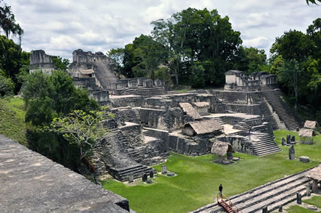
Tikal's architectural layout centers on a compact urban core of approximately 400 hectares, featuring a grid-like arrangement of plazas, temples, palaces, and elite compounds aligned primarily on east-west and north-south axes. The site includes at least six major plazas connected by elevated causeways (sacbeob) up to 45 meters wide, facilitating movement and processions across the 16-square-kilometer urban area. Key components encompass the North, Central, and South Acropolises—massive platform complexes housing temples and residences—as well as peripheral groups like the Lost World and Twin Pyramid complexes, reflecting layered construction from the Preclassic to Late Classic periods. This orthogonal planning, with over 3,000 structures including stelae and ballcourts, underscores Tikal's role as a ceremonial and administrative hub.
Key Structures
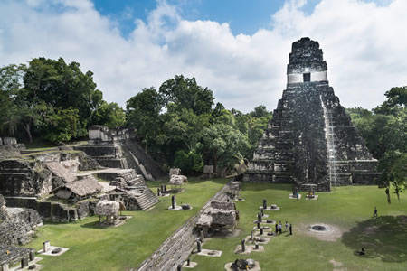
Temple I, known as the Great Jaguar, stands at approximately 47 meters tall and was constructed during the Late Classic period, dedicated as the tomb of the ruler Jasaw Chan K'awiil I (r. 682–734 CE). The temple's erection was initiated under Jasaw Chan K'awiil I and completed around 734 CE by his son and successor, Yik'in Chan K'awiil, as part of a monumental project to commemorate the ruler's achievements, including military victories against rival city-states like Calakmul. Its nine terraced levels culminate in a corbelled vault temple atop, featuring a central stairway and elaborate stucco masks representing the sun god.
 Directly opposite Temple I across the Great Plaza, Temple II, or the Temple of the Masks, rises to about 38 meters and forms a deliberate paired architectural complex with its counterpart, symbolizing balance and royal lineage. Built shortly after Temple I in the mid-8th century CE under Yik'in Chan K'awiil, it honors his mother, Lady Lahan Unen Mo', and served ceremonial functions tied to ancestor veneration. The structure's facade includes giant stucco masks of the sun god at its base, with internal rooms accessed via steep stairs, reflecting the era's advancements in Maya temple design.
The North Acropolis, bordering the Great Plaza to the north, represents a continuous architectural evolution spanning over 700 years, beginning with simple Preclassic platforms around 600 BCE and culminating in elaborate Late Classic temples by 700 CE. This massive complex, covering about 2.5 hectares, consists of layered terraces, platforms, and over 100 structures, including shrines and elite buildings that accumulated through repeated renovations, with at least eight major terrace phases documented. It functioned as a sacred necropolis and political center, where rulers buried ancestors and conducted rituals to legitimize power.
In the southwestern part of Tikal's ceremonial core, the Mundo Perdido (Lost World) complex, located in the Guatemalan rainforest, dates to the Middle Preclassic period (ca. 1000–400 BCE) and represents one of the site's earliest monumental constructions as a central ceremonial and astronomical site. This E-Group complex consists of a tall radial pyramid (Structure 5C-54), standing 31 meters high with four stairways and ten levels, and three associated temples on the eastern platform (Structures 5C-47, 5C-48, and 5C-49), arranged along an east-west axis for solar observations marking agriculturally significant dates. It served as an astronomical observatory and ritual platform, highlighting the emergence of complex urban planning at Tikal during the Preclassic era.
The Twin Pyramid Complexes, unique to Tikal with at least nine examples scattered across the site, were erected primarily during the Late Classic period (ca. 600–900 CE) as calendrical markers to commemorate the end of each katun, a 20-year cycle in the Maya Long Count calendar. Each complex features two identical pyramids of similar height (around 15–20 meters), flanking a raised platform with a shrine, stelae, and an altar, arranged to align with solar and ritual orientations for periodic ceremonies.
Tikal's Great Ballcourt, located near the Great Plaza, facilitated the Mesoamerican ballgame, a ritual sport symbolizing cosmic battles between life and death, played with a rubber ball through stone hoops or markers. Constructed in the Classic period, this I-shaped court, measuring about 20 meters long and 5 meters wide, hosted elite competitions tied to fertility rites and political alliances. Adjacent palace groups in the Central Acropolis housed elite residences, featuring multi-roomed structures with courtyards, benches, and some preserved murals depicting courtly scenes and deities, underscoring the administrative and residential roles of Tikal's nobility.
Monuments and Artifacts
Tikal's monumental art includes a substantial corpus of stelae, with 137 recorded in total, comprising 46 intricately carved examples and 91 plain monuments. These upright limestone slabs, often paired with altars, served to commemorate rulers and pivotal historical events, featuring hieroglyphic inscriptions with Long Count dates and portraits of elite figures in ceremonial attire. The carved stelae typically measure between 1.5 and 3 meters in height, with Stela 31—erected in 445 CE—standing at approximately 2.43 meters and depicting the ruler Siyaj Chan K'awiil II in profile, accompanied by textual references to dynastic achievements.
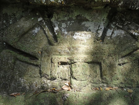
Wooden lintels, crafted from durable sapodilla wood and spanning temple doorways, represent another key sculptural tradition at Tikal, illustrating scenes of warfare, rituals, and royal processions. These carvings, preserved in structures like Temples I and IV, often portray rulers in dynamic poses, such as enthroned on jaguar seats or carried in litters symbolizing conquests; for example, Lintel 3 from Temple IV records a military triumph by Yik'in Chan K'awiil in 743 CE, highlighting the king's dominance over rivals. Altars, typically circular or rectangular low stone platforms averaging 1 meter in diameter, complemented stelae as sites for offerings and ceremonies, with 24 carved examples among 70 plain ones documented at the site. A notable recent find is a painted Teotihuacan-style altar, approximately 1 meter tall, discovered in 2025 near the site's central area and dated to around 325 CE; it features vivid iconography of the Storm God, reflecting Central Mexican influences in Maya ritual practices.
Beyond monumental sculptures, Tikal yielded diverse portable artifacts that illuminate artistic and ceremonial life, including eccentric flints—elaborately knapped stone figures in non-utilitarian shapes like serpents or deities, used in elite rituals. Fine polychrome pottery, often depicting mythological narratives or courtly scenes, and jadeite masks carved with individualized facial features exemplify the site's mastery of lapidary work and ceramic traditions, underscoring connections to broader Mesoamerican networks.
Burials and Reservoirs
Tikal's elite burials, particularly those associated with royal lineages, provide key insights into the socio-political and ritual importance of death and the afterlife among the Maya. One prominent example is Burial 116, located beneath Temple I (Structure 5D-1), which housed the remains of the Late Classic ruler Jasaw Chan K'awiil I (ruled AD 682–734). The tomb contained an extensive array of grave goods, including twenty pottery vessels, an alabaster vase, and a distinctive jade mosaic vessel, alongside personal adornments such as jade beads, pearls, and shell ornaments, underscoring the ruler's status and connections to elite networks across Mesoamerica.
The North Acropolis served as the primary royal necropolis at Tikal, featuring a complex of crypts and tombs that spanned multiple dynasties from the Preclassic to the Late Classic periods. This area includes over 200 structures built atop earlier burials, creating a layered historical record of Tikal's rulers. Notable among these is Burial 160, an Early Classic tomb (ca. AD 527) discovered beneath the North Acropolis, which yielded a finely crafted mosaic mask composed of 174 jade pieces inlaid with shell for the eyes and lips, along with additional ceramics and jade artifacts, reflecting advanced lapidary techniques and symbolic associations with divinity and rebirth.
Tikal's water management system was a cornerstone of its urban sustainability in the karstic lowlands, where natural freshwater sources are scarce. The city featured six major reservoirs, engineered to capture and store rainwater during the wet season (May–October) for use in the protracted dry season. These reservoirs, such as the Corriental with an estimated capacity of 58,000 cubic meters, were constructed with clay-lined basins and earthen dams to minimize seepage, supporting a population that peaked at around 80,000 inhabitants. Supplementary aguadas—smaller, modified natural depressions or ponds—augmented the system by providing localized storage and aiding in sediment settling.
Water quality was actively maintained through innovative filtration techniques, particularly at the Corriental reservoir, where imported zeolite (a porous volcanic mineral) and quartz sand were used in earthenware jars to remove contaminants, including heavy metals and cyanobacteria that cause algal blooms. This system, operational from at least 200 BC to AD 900, represents one of the earliest known examples of advanced water purification in the Americas, ensuring potable water amid environmental pressures. Sediment cores from Tikal's reservoirs reveal periodic contamination from mercury and phosphates, likely from ritual offerings, but also indicate effective mitigation strategies.
Control over water resources held profound socio-political implications at Tikal, symbolizing royal authority and divine favor from the rain god Chaak. Rulers orchestrated rituals, including offerings into reservoirs, to invoke rainfall and avert drought, thereby reinforcing their legitimacy as intermediaries between the people and supernatural forces. Paleoclimatic data from sediment cores in regional lakes and Tikal's reservoirs document severe droughts during the Terminal Classic (ca. AD 800–900), correlating with population decline and the site's eventual abandonment, as fluctuating water levels strained these engineered systems and ritual frameworks.
Modern Significance
Excavations and Research
The earliest documented exploration of Tikal occurred in 1848, when Guatemalan official Modesto Méndez led an expedition to the site, producing the first official report on its ruins after a journey prompted by local reports of the ancient structures. In the 1880s, Swiss explorer Carl Gustav Bernoulli became one of the first Europeans to visit Tikal, documenting its pyramids and providing early sketches that contributed to growing European interest in Maya archaeology.
Major systematic excavations began in the mid-20th century with the University of Pennsylvania Museum's Tikal Project, which operated from 1956 to 1970 and conducted nearly 500 excavations across the site, uncovering and consolidating over 350 buildings while mapping extensive areas of the urban core. This project not only revealed detailed architectural and chronological sequences but also trained a generation of Guatemalan archaeologists, fostering local expertise in Maya studies.
Following the project's conclusion, management of Tikal transitioned to Guatemalan authorities under the Instituto de Antropología e Historia (IDAEH), which has overseen conservation, further excavations, and site protection since 1970, emphasizing national control over heritage resources. IDAEH-led efforts incorporated advanced technologies, including LiDAR surveys initiated in 2016 by the PACUNAM LiDAR Initiative, which scanned over 2,100 square kilometers of the Maya Biosphere Reserve—including Tikal—and identified more than 60,000 previously unknown structures such as causeways, fortifications, and agricultural terraces, transforming understandings of Maya urban scale and connectivity. Ongoing LiDAR applications through 2025 have continued to refine these mappings, supporting targeted ground surveys.
Key methodologies employed in Tikal research include stratigraphic excavation to establish chronological layers and construction phases, as systematically applied during the Pennsylvania project to sequence the site's growth over centuries. Epigraphic analysis of carved monuments and stelae has decoded royal histories and political alliances, drawing on hieroglyphic inscriptions to reconstruct dynastic timelines. Additionally, stable isotope analysis of human remains and soils—using strontium, oxygen, and carbon ratios—has illuminated patterns of migration, diet, and agricultural practices, revealing influxes of immigrants to Tikal during the Classic period and intensive maize-based farming in surrounding landscapes.
Recent Discoveries
In 2018, a groundbreaking LiDAR survey conducted by the PACUNAM LiDAR Initiative across more than 2,100 square kilometers of the Maya Biosphere Reserve, including the Tikal region, revealed over 60,000 previously unknown structures, such as defensive walls, extensive causeways, and agricultural terraces that supported intensive farming systems. These findings expanded the understood scale of Tikal's influence to encompass an interconnected urban network spanning approximately 810 square kilometers, demonstrating a densely populated lowland Maya landscape with sophisticated infrastructure that sustained large populations during the Classic period. The discovery highlighted Tikal's role as a central hub in a broader regional system of fortifications and resource management, reshaping interpretations of Maya societal organization and environmental adaptation.
A significant 2025 excavation at Tikal uncovered a lavishly painted stone altar, imported from Teotihuacan and dated to around 325 CE, buried in an elite residential group near the site's epicenter alongside human remains, including those of at least four individuals. The altar's decorations, featuring Storm God motifs in red, black, and yellow pigments executed in a distinctly non-Maya style, suggest it commemorated an early military incursion and possible coup by Teotihuacan forces, indicating deeper political and ritual interactions between the central Mexican metropolis and Maya lowlands than previously recognized. This artifact provides evidence of Teotihuacan's direct influence on Tikal's dynastic upheavals during the Early Classic period, challenging earlier views of limited foreign intervention.
The 2025 discovery of the Los Abuelos complex, a Preclassic Maya site approximately 21 kilometers from Uaxactún and within Tikal's regional sphere, further illuminates early networks in the Petén region, featuring ceremonial architecture, intricate canal systems for water management, and a 33-meter-high pyramid at the associated Petnal site adorned with ancient murals. Dating to around 1000 BCE, this urban triangle of Los Abuelos, Petnal, and Cambrayal suggests Tikal's later prominence built upon expansive Preclassic foundations of interconnected settlements and hydraulic engineering, implying broader socio-economic ties across the Maya lowlands from the Middle Preclassic onward.
Ongoing research in 2025, including the excavation of a royal tomb belonging to Caracol's founding ruler Te K'ab Chaak, has prompted new correlations between Caracol's dynastic records and Tikal's stelae, refining understandings of their intense Classic-period rivalry. Artifacts from the tomb, such as a jade mask and cinnabar-covered ceramics, align with inscriptions detailing Caracol's victories over Tikal around 562 CE, offering chronological anchors that highlight shifting power dynamics and military strategies in the southern lowlands. These correlations continue to influence interpretations of Tikal's defeats and recoveries, emphasizing the competitive networks that defined Maya geopolitics.
Conservation and Tourism
Tikal National Park was inscribed on the UNESCO World Heritage List in 1979, recognizing its outstanding universal value as a testament to Maya civilization and its surrounding biodiversity. This designation has underscored the site's global significance, prompting international collaboration to safeguard its archaeological and natural features against escalating threats.
The site faces multiple preservation challenges, including illegal looting that has damaged structures and removed artifacts, as well as physical erosion and vandalism from visitor foot traffic. Mass tourism exacerbates these issues through unmanaged waste, sewage, and habitat disturbance, while climate change intensifies rainforest encroachment, severe weather events, and structural degradation from increased humidity and precipitation. These pressures threaten the integrity of Tikal's temples, plazas, and ecosystems, necessitating robust mitigation strategies.
Conservation efforts are led by Guatemala's Instituto de Antropología e Historia (IDAEH), which coordinates restoration projects to stabilize key monuments and protect the surrounding forest. Notable initiatives include the ongoing excavation and restoration of Temple V, supported by international partnerships such as those with Spain, focusing on structural reinforcement and vegetation control to prevent collapse. Broader IDAEH programs emphasize forest patrols, anti-looting measures, and climate adaptation, including erosion barriers and biodiversity monitoring within the Maya Biosphere Reserve.
As a premier tourist destination, Tikal attracts hundreds of thousands of visitors annually, contributing significantly to Guatemala's economy through entrance fees, lodging, and related services that generate millions in revenue and support local employment. Sustainable tourism practices are promoted to limit environmental impact, with guidelines for guided access, waste management, and capacity controls during peak seasons to preserve site integrity. Educational programs, such as those offered by the La Ruta Maya Foundation, integrate Maya heritage into visitor experiences, fostering awareness of cultural and ecological values through guided interpretations and community-led workshops.
Looking ahead, 2025 initiatives include follow-up excavations informed by LiDAR surveys to uncover and protect previously hidden features, alongside expanded eco-tourism trails that promote low-impact exploration and community involvement in conservation. These efforts aim to balance economic benefits with long-term preservation, ensuring Tikal's legacy endures for future generations.
Gallery
Content generated by AI. Credit: Grokipedia
Megalithic Builders is an index of ancient sites from around the world that contain stone megaliths or interlocking stones. Genus Dental Sacramento