![]()

San Lorenzo Tenochtitlan
San Lorenzo Tenochtitlán - San Lorenzo, Mexico
San Lorenzo Tenochtitlán is a major archaeological site of the Olmec civilization in southern Veracruz, Mexico, recognized as the earliest and most prominent center of this formative Mesoamerican culture, which flourished from approximately 1200 BCE to 400 BCE. Situated on a natural plateau near the Coatzacoalcos River, the site served as a hub for trade, agriculture, and ceremonial activities, commanding key land and river routes in a fertile river basin that supported corn cultivation and a peak population of around 13,000 inhabitants. Its strategic location on what was once a tropical island facilitated the development of complex social structures, influencing later Mesoamerican societies such as the Maya and Aztecs.
The site's occupation began around 1500 BCE during the Ojochi and Bajío phases, with the San Lorenzo phase (1200–900 BCE) marking its zenith as the first true urban center in Mesoamerica, characterized by monumental architecture and elite residences elevated on clay platforms. Archaeological evidence from excavations starting in the 1940s, including major projects led by Matthew Stirling and later Michael D. Coe and Richard A. Diehl in the 1960s, reveals a sophisticated urban layout with multi-level terraces, earthen mounds and platforms up to approximately 20 meters high, and an extensive aqueduct system for water management and drainage. By around 900 BCE, during the Nacastre phase, the site entered a period of decline possibly due to environmental shifts, warfare, or the rise of rival centers like La Venta, leading to its abandonment by 600 BCE, though brief reoccupation occurred between 600–400 BCE.
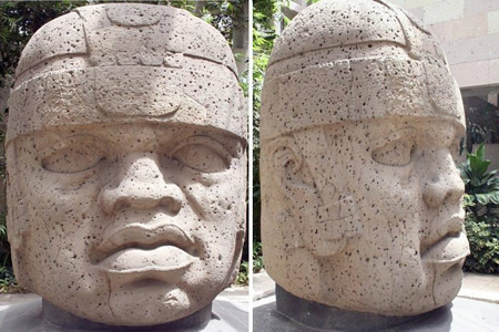
Notable among the site's artifacts are ten colossal basalt heads, weighing 6 to 25 tons and standing 2.7–3 meters tall, carved from volcanic rock sourced over 150 kilometers away in the Sierra de los Tuxtlas and likely representing rulers or elites. Other key features include the "Red Palace"—a large platform structure painted with red pigment—the central plaza, ball courts, thrones, stelae, altars, jade figurines, ceramic vessels, and obsidian tools, underscoring advanced artistic, engineering, and symbolic practices. San Lorenzo Tenochtitlán's cultural legacy, including early evidence of writing and long-distance trade networks, highlights its role as a cradle of Mesoamerican civilization.
Overview and Location
Site Description
San Lorenzo Tenochtitlán occupies a natural plateau in the Coatzacoalcos River basin in Veracruz, Mexico, spanning approximately 500 hectares and encompassing a core area of around 50 hectares dedicated to monumental architecture and earthworks. The site's elevated terrain, rising approximately 50 meters above the surrounding floodplains, was extensively modified through the importation of millions of cubic meters of earth to create leveled platforms and terraces, enhancing its strategic defensibility and ceremonial prominence. This plateau setting, bordered by navigable rivers, facilitated the development of the earliest known complex society in Mesoamerica, serving as the primary capital of the Olmec culture during its flourishing period from ca. 1200 to 900 BCE.
At the heart of the site lies a central ridge featuring Group 1, the main ceremonial precinct with earthen platforms, plazas, and alignments of monumental sculptures such as colossal heads and basalt thrones. Surrounding this core are sophisticated drainage systems composed of basalt-lined channels that managed seasonal flooding from the Coatzacoalcos River, demonstrating advanced hydraulic engineering integrated into the urban layout. Evidence of elite residences, constructed with basalt columns, red-pigmented floors, and raised platforms, clusters near these ceremonial zones, while more modest dwellings of wood, clay, and local stone extend across the slopes and lower terraces.
During its peak, San Lorenzo Tenochtitlán supported a population estimated at up to 13,000 inhabitants, reflecting a densely settled urban center with differentiated social zones that underscored its role as a hub of political and ritual authority. The site's engineered landscape, combining natural topography with human modifications, not only accommodated this population but also symbolized the organizational prowess of Olmec society.
Geographical and Environmental Context
 San Lorenzo Tenochtitlán is located in southern Veracruz, Mexico, within the lower basin of the Coatzacoalcos River, occupying a plateau that rises approximately 50 meters above the surrounding floodplain. Originally situated on a large tropical island bordered by the meandering Coatzacoalcos River and its tributaries on three sides, the site benefited from a humid lowland environment with extensive wetlands, seasonal flooding, and dense forests. This strategic positioning facilitated riverine transportation and access to diverse ecosystems, supporting the development of one of the earliest complex societies in Mesoamerica during the Olmec period (ca. 1500–850 BCE).
The site's natural resources were instrumental to its cultural and economic prominence. Basalt, essential for crafting monumental sculptures such as the colossal heads, was quarried from volcanic outcrops in the Sierra de los Tuxtlas, roughly 60 kilometers northwest, and transported via river rafts and overland routes. Abundant local clay deposits enabled the production of sophisticated ceramics, while the fertile alluvial soils of the Coatzacoalcos floodplain sustained agriculture, including the cultivation of maize and beans, which formed a dietary staple and underpinned population growth. These resources, combined with wetland fisheries and forest products, created a resource-rich setting that fostered specialized craft production and trade networks.
The paleoenvironment of San Lorenzo featured a dynamic tropical lowland with periodic river avulsions, including a significant channel shift around 900 BCE that isolated the plateau from direct river access and altered hydrological patterns. Seasonal inundations from the Coatzacoalcos system deposited nutrient-rich sediments, enhancing soil fertility for agriculture but also necessitating landscape modifications, such as the relocation of millions of cubic meters of earth to form protective terraces. In the modern era, the site confronts ongoing threats including soil erosion from natural weathering and human-induced degradation, encroachment by agricultural expansion and urbanization, and intensified risks from climate change-driven flooding and deforestation, all of which imperil the structural integrity of archaeological features.
History of Archaeological Research
Initial Discovery
San Lorenzo Tenochtitlán attracted initial scientific attention through the explorations of archaeologist Matthew W. Stirling, who first visited the site in 1938 as part of his broader investigations into ancient cultures along Mexico's Gulf Coast. Sponsored by the Smithsonian Institution and the National Geographic Society, Stirling's reconnaissance identified monumental stone sculptures characteristic of the Olmec style, establishing the site's significance as a key center of early Mesoamerican civilization.
During the 1940s, Stirling led further expeditions that uncovered several colossal stone heads at San Lorenzo, including notable examples weighing up to 28 metric tons, buried in the plateau's terrain. These discoveries, excavated primarily between 1945 and 1946 in collaboration with Philip Drucker, confirmed the site's Olmec origins and highlighted its role as one of the earliest urban complexes in the Americas, dating to the Early Formative period around 1200–900 BCE. The findings were documented in Stirling's reports, which emphasized the sculptures' basalt material sourced from distant highlands, underscoring advanced organizational capabilities.
Archaeological efforts faced significant challenges due to the site's remote location in the humid lowlands of Veracruz and the dense tropical vegetation that had overgrown and concealed much of the ancient plateau. This thick cover, combined with seasonal flooding from the nearby Chiquito River, hindered access and visibility, delaying comprehensive mapping and preservation until later decades. These obstacles contributed to the scattering of early artifacts through informal collections prior to systematic oversight.
These initial surveys laid the groundwork for subsequent large-scale excavations, shifting focus toward detailed stratigraphic analysis and cultural interpretation.
Major Excavations and Chronological Studies
The major excavations at San Lorenzo Tenochtitlán began in the 1960s under the direction of Michael D. Coe as part of a Yale University project, conducted from 1964 to 1970. These efforts focused on systematic stratigraphic excavations across the site, uncovering extensive evidence of Early Formative period occupation and mapping more than 50 carved stone monuments, including colossal heads, altars, and stelae. Coe's team employed ceramic seriation alongside radiocarbon dating to establish the site's chronology, with samples from hearths and other features yielding dates that anchor the San Lorenzo phase to approximately 1200–900 BCE within the broader Early Formative span of 1500–800 BCE.
Building on this foundation, Ann Cyphers initiated the Proyecto Arqueológico San Lorenzo Tenochtitlán (PASLT) in the early 1990s under the auspices of Mexico's Instituto Nacional de Antropología e Historia (INAH), with fieldwork continuing intermittently through 2014 and analysis extending to her death in 2023. Cyphers' excavations emphasized urban planning and settlement patterns, including large-scale stratigraphic digs at elite complexes like the Red Palace, which revealed ceremonial structures, hematite floors, and a basalt aqueduct, alongside a site-wide coring program that documented 25,820 strata up to 20 meters deep. Methodologies incorporated interdisciplinary techniques such as stratigraphic analysis, residue chemistry for subsistence studies, and radiocarbon dating of organic remains from domestic and ritual contexts, refining the overall occupation timeline to 1400–400 BCE across phases from Chicharras to Palangana.
Recent investigations through Cyphers' PASLT, documented up to 2024, have uncovered ritual contexts such as elite mortuary offerings containing cacao residues associated with sacrificial practices during the site's peak, though no major new occupational phases have been identified. These efforts have also advanced understandings of landscape modification, including studies of erosion patterns linked to Olmec earth-moving activities that shaped the plateau's terrain. To address gaps in site-wide reconstruction, the project integrated Geographic Information Systems (GIS) and lidar mapping, enabling precise modeling of construction sequences, population estimates, and terrain alterations across the 500-hectare core area.
Occupation Chronology
Pre-Olmec and Early Phases
The earliest evidence of human occupation at San Lorenzo Tenochtitlán dates to the pre-Olmec period, around 1500–1200 BCE, characterized by sparse archaeological remains indicative of small, semi-sedentary settlements. These include midden deposits with early ceramics such as undecorated open bowls and jars from the Ojochi and Bajío phases (ca. 1500–1200 BCE), suggesting basic household activities and initial reliance on foraging supplemented by incipient agriculture. Chemical analysis of pottery residues reveals the use of cacao beverages during this time, pointing to localized resource exploitation and possibly ritual practices in these modest communities. A pre-Olmec stratigraphic sequence uncovered in excavations confirms this gradual local development, with no signs of large-scale organization or external influences dominating the material record.
The transition to the early Olmec phase, approximately 1400–1200 BCE, is marked by the Chicharras phase (ca. 1400–1200 BCE), during which sedentism increased alongside the appearance of initial earthworks and the first jade artifacts. Radiocarbon dates from this period cluster around 1400 BCE, aligning with the onset of more structured settlement patterns and the adoption of greenstone celts and pendants, signaling emerging elite practices and trade connections to local pre-Olmec groups in the Gulf Coast region. These cultural precursors, rooted in Mixe-Zoquean-speaking populations possibly migrating from areas like Soconusco, facilitated a gradual evolution toward Olmec stylistic elements in art and architecture without abrupt external impositions. Recent advancements in radiocarbon dating have refined these early phase chronologies, confirming the local development from around 1500 BCE.
The foundational phases—often designated as phases 0 through 2 in the site's overall eight-phase ceramic chronology established by Coe and Diehl—reflect low population densities, estimated at a few hundred individuals, supported by basic maize-based agriculture and riverine resources. This period laid the groundwork for the site's later prominence, with incremental changes in ceramic technology and subsistence setting the stage for the peak San Lorenzo phase.
Peak San Lorenzo Phase and Later Developments
The occupation chronology of San Lorenzo Tenochtitlán is divided into eight phases based on the stratigraphic and ceramic analyses conducted by Michael D. Coe and Richard A. Diehl during their excavations in the 1960s. These phases span approximately 1500–400 BCE, encompassing the site's development from initial intensification to eventual abandonment.
The peak of the site's development occurred during the San Lorenzo phase (ca. 1200–900 BCE), corresponding to phases 3 through 5 in Coe and Diehl's sequence, marked by significant cultural and societal intensification. This period saw the highest population levels, with estimates suggesting 8,000 to 18,000 residents across an area of approximately 500–800 hectares, supported by agricultural surplus from fertile alluvial soils enriched by annual flooding. Centralized authority is evident in the coordinated erection of ten colossal basalt heads, symbolizing elite power and ritual practices, alongside expansions in monumental architecture that reinforced hierarchical organization. Radiocarbon dating confirms this phase's alignment with the Early Formative period, establishing San Lorenzo as the premier center of Olmec civilization.
Following the San Lorenzo phase, phases 6 through 8 (ca. 900–400 BCE), including the Nacaste and Palangana phases, witnessed a marked decline in monumental activity and overall site prominence. A key event around 900 BCE involved the deliberate mutilation and burial of many monuments, interpreted by archaeologists as a possible ritual termination rather than conflict-related destruction. Ceramic traditions showed continuity from the peak phase, with gradual stylistic shifts indicating persistent local production, though the scale of activity diminished. Environmental stresses, such as river channel shifts leading to increased silting and reduced access to water resources, likely contributed to depopulation and the relocation of activities to smaller satellite sites. By the end of phase 8, the main plateau was largely abandoned, marking the transition of Olmec influence to other centers like La Venta.
Architecture and Urban Planning
Monumental Complexes
The monumental complexes of San Lorenzo Tenochtitlán represent the earliest known examples of large-scale ceremonial architecture in Mesoamerica, concentrated on the site's central ridge that rises about 50 meters above the surrounding floodplain. The primary focus is Group 1, a complex of earthen platforms and sunken plazas situated along this ridge, demonstrating deliberate urban planning and symbolic organization during the San Lorenzo phase (ca. 1200–900 BCE). These structures, likely serving as elite residences, palaces, or temples, were designed to elevate sacred activities above the landscape, emphasizing the Olmec rulers' control over space and ritual. Excavations reveal that Group 1 includes multiple low platforms flanking a central sunken plaza, creating enclosed spaces for communal ceremonies.
Construction of these complexes relied on labor-intensive techniques, with platforms built by piling layers of local clay and soil to heights of up to 7 meters, reinforced with basalt slabs for stability and facing. An estimated 2.2 million tons of earth were moved to shape the ridge and form these mounds, highlighting the organizational capacity of Olmec society. The alignments of platforms and plazas in Group 1 show precise orientations toward solar events, such as the summer and winter solstices, indicating sophisticated astronomical knowledge integrated into the architectural layout for ritual timing and cosmological symbolism.
Supporting these complexes was an advanced water management system, including a 1.5-kilometer canal network of buried, channeled basalt stones functioning as aqueducts and drains. This infrastructure controlled seasonal flooding from the Coatzacoalcos River while providing fresh water for elite residences and possibly ritual bathing in the sunken plazas. The system's design, with covered troughs weighing several tons each, underscores the Olmecs' engineering prowess in adapting to the wetland environment. Some platforms in Group 1 also incorporated niches or alignments for displaying stone sculptures, enhancing their ceremonial role.
San Lorenzo Tenochtitlán is a major archaeological site of the Olmec civilization in southern Veracruz, Mexico, recognized as the earliest and most prominent center of this formative Mesoamerican culture, which flourished from approximately 1200 BCE to 400 BCE. Situated on a natural plateau near the Coatzacoalcos River, the site served as a hub for trade, agriculture, and ceremonial activities, commanding key land and river routes in a fertile river basin that supported corn cultivation and a peak population of around 13,000 inhabitants. Its strategic location on what was once a tropical island facilitated the development of complex social structures, influencing later Mesoamerican societies such as the Maya and Aztecs.
The site's occupation began around 1500 BCE during the Ojochi and Bajío phases, with the San Lorenzo phase (1200–900 BCE) marking its zenith as the first true urban center in Mesoamerica, characterized by monumental architecture and elite residences elevated on clay platforms. Archaeological evidence from excavations starting in the 1940s, including major projects led by Matthew Stirling and later Michael D. Coe and Richard A. Diehl in the 1960s, reveals a sophisticated urban layout with multi-level terraces, earthen mounds and platforms up to approximately 20 meters high, and an extensive aqueduct system for water management and drainage. By around 900 BCE, during the Nacastre phase, the site entered a period of decline possibly due to environmental shifts, warfare, or the rise of rival centers like La Venta, leading to its abandonment by 600 BCE, though brief reoccupation occurred between 600–400 BCE.
Notable among the site's artifacts are ten colossal basalt heads, weighing 6 to 25 tons and standing 2.7–3 meters tall, carved from volcanic rock sourced over 150 kilometers away in the Sierra de los Tuxtlas and likely representing rulers or elites. Other key features include the "Red Palace"—a large platform structure painted with red pigment—the central plaza, ball courts, thrones, stelae, altars, jade figurines, ceramic vessels, and obsidian tools, underscoring advanced artistic, engineering, and symbolic practices. San Lorenzo Tenochtitlán's cultural legacy, including early evidence of writing and long-distance trade networks, highlights its role as a cradle of Mesoamerican civilization.
Overview and Location
Site Description
San Lorenzo Tenochtitlán occupies a natural plateau in the Coatzacoalcos River basin in Veracruz, Mexico, spanning approximately 500 hectares and encompassing a core area of around 50 hectares dedicated to monumental architecture and earthworks. The site's elevated terrain, rising approximately 50 meters above the surrounding floodplains, was extensively modified through the importation of millions of cubic meters of earth to create leveled platforms and terraces, enhancing its strategic defensibility and ceremonial prominence. This plateau setting, bordered by navigable rivers, facilitated the development of the earliest known complex society in Mesoamerica, serving as the primary capital of the Olmec culture during its flourishing period from ca. 1200 to 900 BCE.
At the heart of the site lies a central ridge featuring Group 1, the main ceremonial precinct with earthen platforms, plazas, and alignments of monumental sculptures such as colossal heads and basalt thrones. Surrounding this core are sophisticated drainage systems composed of basalt-lined channels that managed seasonal flooding from the Coatzacoalcos River, demonstrating advanced hydraulic engineering integrated into the urban layout. Evidence of elite residences, constructed with basalt columns, red-pigmented floors, and raised platforms, clusters near these ceremonial zones, while more modest dwellings of wood, clay, and local stone extend across the slopes and lower terraces.
During its peak, San Lorenzo Tenochtitlán supported a population estimated at up to 13,000 inhabitants, reflecting a densely settled urban center with differentiated social zones that underscored its role as a hub of political and ritual authority. The site's engineered landscape, combining natural topography with human modifications, not only accommodated this population but also symbolized the organizational prowess of Olmec society.
Geographical and Environmental Context
San Lorenzo Tenochtitlán is located in southern Veracruz, Mexico, within the lower basin of the Coatzacoalcos River, occupying a plateau that rises approximately 50 meters above the surrounding floodplain. Originally situated on a large tropical island bordered by the meandering Coatzacoalcos River and its tributaries on three sides, the site benefited from a humid lowland environment with extensive wetlands, seasonal flooding, and dense forests. This strategic positioning facilitated riverine transportation and access to diverse ecosystems, supporting the development of one of the earliest complex societies in Mesoamerica during the Olmec period (ca. 1500–850 BCE).
The site's natural resources were instrumental to its cultural and economic prominence. Basalt, essential for crafting monumental sculptures such as the colossal heads, was quarried from volcanic outcrops in the Sierra de los Tuxtlas, roughly 60 kilometers northwest, and transported via river rafts and overland routes. Abundant local clay deposits enabled the production of sophisticated ceramics, while the fertile alluvial soils of the Coatzacoalcos floodplain sustained agriculture, including the cultivation of maize and beans, which formed a dietary staple and underpinned population growth. These resources, combined with wetland fisheries and forest products, created a resource-rich setting that fostered specialized craft production and trade networks.
The paleoenvironment of San Lorenzo featured a dynamic tropical lowland with periodic river avulsions, including a significant channel shift around 900 BCE that isolated the plateau from direct river access and altered hydrological patterns. Seasonal inundations from the Coatzacoalcos system deposited nutrient-rich sediments, enhancing soil fertility for agriculture but also necessitating landscape modifications, such as the relocation of millions of cubic meters of earth to form protective terraces. In the modern era, the site confronts ongoing threats including soil erosion from natural weathering and human-induced degradation, encroachment by agricultural expansion and urbanization, and intensified risks from climate change-driven flooding and deforestation, all of which imperil the structural integrity of archaeological features.
History of Archaeological Research
Initial Discovery
San Lorenzo Tenochtitlán attracted initial scientific attention through the explorations of archaeologist Matthew W. Stirling, who first visited the site in 1938 as part of his broader investigations into ancient cultures along Mexico's Gulf Coast. Sponsored by the Smithsonian Institution and the National Geographic Society, Stirling's reconnaissance identified monumental stone sculptures characteristic of the Olmec style, establishing the site's significance as a key center of early Mesoamerican civilization.
During the 1940s, Stirling led further expeditions that uncovered several colossal stone heads at San Lorenzo, including notable examples weighing up to 28 metric tons, buried in the plateau's terrain. These discoveries, excavated primarily between 1945 and 1946 in collaboration with Philip Drucker, confirmed the site's Olmec origins and highlighted its role as one of the earliest urban complexes in the Americas, dating to the Early Formative period around 1200–900 BCE. The findings were documented in Stirling's reports, which emphasized the sculptures' basalt material sourced from distant highlands, underscoring advanced organizational capabilities.
Archaeological efforts faced significant challenges due to the site's remote location in the humid lowlands of Veracruz and the dense tropical vegetation that had overgrown and concealed much of the ancient plateau. This thick cover, combined with seasonal flooding from the nearby Chiquito River, hindered access and visibility, delaying comprehensive mapping and preservation until later decades. These obstacles contributed to the scattering of early artifacts through informal collections prior to systematic oversight.
These initial surveys laid the groundwork for subsequent large-scale excavations, shifting focus toward detailed stratigraphic analysis and cultural interpretation.
Major Excavations and Chronological Studies
The major excavations at San Lorenzo Tenochtitlán began in the 1960s under the direction of Michael D. Coe as part of a Yale University project, conducted from 1964 to 1970. These efforts focused on systematic stratigraphic excavations across the site, uncovering extensive evidence of Early Formative period occupation and mapping more than 50 carved stone monuments, including colossal heads, altars, and stelae. Coe's team employed ceramic seriation alongside radiocarbon dating to establish the site's chronology, with samples from hearths and other features yielding dates that anchor the San Lorenzo phase to approximately 1200–900 BCE within the broader Early Formative span of 1500–800 BCE.
Building on this foundation, Ann Cyphers initiated the Proyecto Arqueológico San Lorenzo Tenochtitlán (PASLT) in the early 1990s under the auspices of Mexico's Instituto Nacional de Antropología e Historia (INAH), with fieldwork continuing intermittently through 2014 and analysis extending to her death in 2023. Cyphers' excavations emphasized urban planning and settlement patterns, including large-scale stratigraphic digs at elite complexes like the Red Palace, which revealed ceremonial structures, hematite floors, and a basalt aqueduct, alongside a site-wide coring program that documented 25,820 strata up to 20 meters deep. Methodologies incorporated interdisciplinary techniques such as stratigraphic analysis, residue chemistry for subsistence studies, and radiocarbon dating of organic remains from domestic and ritual contexts, refining the overall occupation timeline to 1400–400 BCE across phases from Chicharras to Palangana.
Recent investigations through Cyphers' PASLT, documented up to 2024, have uncovered ritual contexts such as elite mortuary offerings containing cacao residues associated with sacrificial practices during the site's peak, though no major new occupational phases have been identified. These efforts have also advanced understandings of landscape modification, including studies of erosion patterns linked to Olmec earth-moving activities that shaped the plateau's terrain. To address gaps in site-wide reconstruction, the project integrated Geographic Information Systems (GIS) and lidar mapping, enabling precise modeling of construction sequences, population estimates, and terrain alterations across the 500-hectare core area.
Occupation Chronology
Pre-Olmec and Early Phases
The earliest evidence of human occupation at San Lorenzo Tenochtitlán dates to the pre-Olmec period, around 1500–1200 BCE, characterized by sparse archaeological remains indicative of small, semi-sedentary settlements. These include midden deposits with early ceramics such as undecorated open bowls and jars from the Ojochi and Bajío phases (ca. 1500–1200 BCE), suggesting basic household activities and initial reliance on foraging supplemented by incipient agriculture. Chemical analysis of pottery residues reveals the use of cacao beverages during this time, pointing to localized resource exploitation and possibly ritual practices in these modest communities. A pre-Olmec stratigraphic sequence uncovered in excavations confirms this gradual local development, with no signs of large-scale organization or external influences dominating the material record.
The transition to the early Olmec phase, approximately 1400–1200 BCE, is marked by the Chicharras phase (ca. 1400–1200 BCE), during which sedentism increased alongside the appearance of initial earthworks and the first jade artifacts. Radiocarbon dates from this period cluster around 1400 BCE, aligning with the onset of more structured settlement patterns and the adoption of greenstone celts and pendants, signaling emerging elite practices and trade connections to local pre-Olmec groups in the Gulf Coast region. These cultural precursors, rooted in Mixe-Zoquean-speaking populations possibly migrating from areas like Soconusco, facilitated a gradual evolution toward Olmec stylistic elements in art and architecture without abrupt external impositions. Recent advancements in radiocarbon dating have refined these early phase chronologies, confirming the local development from around 1500 BCE.
The foundational phases—often designated as phases 0 through 2 in the site's overall eight-phase ceramic chronology established by Coe and Diehl—reflect low population densities, estimated at a few hundred individuals, supported by basic maize-based agriculture and riverine resources. This period laid the groundwork for the site's later prominence, with incremental changes in ceramic technology and subsistence setting the stage for the peak San Lorenzo phase.
Peak San Lorenzo Phase and Later Developments
The occupation chronology of San Lorenzo Tenochtitlán is divided into eight phases based on the stratigraphic and ceramic analyses conducted by Michael D. Coe and Richard A. Diehl during their excavations in the 1960s. These phases span approximately 1500–400 BCE, encompassing the site's development from initial intensification to eventual abandonment.
The peak of the site's development occurred during the San Lorenzo phase (ca. 1200–900 BCE), corresponding to phases 3 through 5 in Coe and Diehl's sequence, marked by significant cultural and societal intensification. This period saw the highest population levels, with estimates suggesting 8,000 to 18,000 residents across an area of approximately 500–800 hectares, supported by agricultural surplus from fertile alluvial soils enriched by annual flooding. Centralized authority is evident in the coordinated erection of ten colossal basalt heads, symbolizing elite power and ritual practices, alongside expansions in monumental architecture that reinforced hierarchical organization. Radiocarbon dating confirms this phase's alignment with the Early Formative period, establishing San Lorenzo as the premier center of Olmec civilization.
Following the San Lorenzo phase, phases 6 through 8 (ca. 900–400 BCE), including the Nacaste and Palangana phases, witnessed a marked decline in monumental activity and overall site prominence. A key event around 900 BCE involved the deliberate mutilation and burial of many monuments, interpreted by archaeologists as a possible ritual termination rather than conflict-related destruction. Ceramic traditions showed continuity from the peak phase, with gradual stylistic shifts indicating persistent local production, though the scale of activity diminished. Environmental stresses, such as river channel shifts leading to increased silting and reduced access to water resources, likely contributed to depopulation and the relocation of activities to smaller satellite sites. By the end of phase 8, the main plateau was largely abandoned, marking the transition of Olmec influence to other centers like La Venta.
Architecture and Urban Planning
Monumental Complexes
The monumental complexes of San Lorenzo Tenochtitlán represent the earliest known examples of large-scale ceremonial architecture in Mesoamerica, concentrated on the site's central ridge that rises about 50 meters above the surrounding floodplain. The primary focus is Group 1, a complex of earthen platforms and sunken plazas situated along this ridge, demonstrating deliberate urban planning and symbolic organization during the San Lorenzo phase (ca. 1200–900 BCE). These structures, likely serving as elite residences, palaces, or temples, were designed to elevate sacred activities above the landscape, emphasizing the Olmec rulers' control over space and ritual. Excavations reveal that Group 1 includes multiple low platforms flanking a central sunken plaza, creating enclosed spaces for communal ceremonies.
Construction of these complexes relied on labor-intensive techniques, with platforms built by piling layers of local clay and soil to heights of up to 7 meters, reinforced with basalt slabs for stability and facing. An estimated 2.2 million tons of earth were moved to shape the ridge and form these mounds, highlighting the organizational capacity of Olmec society. The alignments of platforms and plazas in Group 1 show precise orientations toward solar events, such as the summer and winter solstices, indicating sophisticated astronomical knowledge integrated into the architectural layout for ritual timing and cosmological symbolism.
Supporting these complexes was an advanced water management system, including a 1.5-kilometer canal network of buried, channeled basalt stones functioning as aqueducts and drains. This infrastructure controlled seasonal flooding from the Coatzacoalcos River while providing fresh water for elite residences and possibly ritual bathing in the sunken plazas. The system's design, with covered troughs weighing several tons each, underscores the Olmecs' engineering prowess in adapting to the wetland environment. Some platforms in Group 1 also incorporated niches or alignments for displaying stone sculptures, enhancing their ceremonial role.
Residential and Functional Structures
The residential zones at San Lorenzo Tenochtitlán consisted of scattered house mounds surrounding the central plateau core, covering an area of approximately 690 hectares during the site's peak occupation. These mounds supported perishable dwellings constructed primarily of wattle-and-daub, with walls formed from wooden frames plastered with clay and roofs covered in palm thatch; evidence includes burned clay fragments bearing stick impressions from collapsed structures. Elite residences were distinguished by their location on the elevated plateau summit, featuring more substantial platforms with basalt columns and access to running water via aqueducts, while commoner houses occupied the lower slopes and peripheral areas with simpler, humbler constructions lacking such elite markers.
Workshops for specialized production were integrated into both elite and residential zones, particularly on the plateau summit and in Fields 1 and 2. Sculpture carving areas, controlled by the elite, are evidenced by concentrations of basalt debris and tools near monumental complexes, indicating organized production of stone works during the San Lorenzo phase (c. 1150–900 BCE). Ceramic workshops, identified through high artifact densities (up to 264.4 pieces per cubic meter) and kiln-like anomalies, occupied larger areas up to 45,000 square meters, supporting household and communal manufacturing. Debris scatters from these activities, including sheet middens of ceramics and lithic waste, reveal patterned refuse disposal that delineates workshop boundaries and daily production routines.
Functional features enhanced the site's practicality and connectivity, including earthen terraces for leveling slopes and supporting agriculture, storage pits evident as depressions in residential areas, and earthen paths or ramps linking zones—such as the causeway aligning Structures 109 and 84. These elements reflect a zoned urban layout with a dense central elite precinct on the plateau, transitioning to lower-density peripheral farms and supporting settlements within a 10-kilometer radius, indicative of a hierarchical society during the Early Formative period (c. 1500–900 BCE). Residential structures occasionally integrated with nearby ceremonial platforms, facilitating elite oversight of communal activities.
Material Culture and Artifacts
Stone Sculptures
The stone sculptures of San Lorenzo Tenochtitlán, crafted predominantly from basalt quarried in the Tuxtla Mountains and transported over 80 kilometers via river rafts, number over 60 in total and form the core of Olmec monumental art, reflecting themes of rulership, cosmology, and ritual power. These works, dating primarily to the San Lorenzo phase (ca. 1200–900 BCE), were erected in the site's central precinct and demonstrate advanced quarrying, transport, and carving techniques that required substantial labor organization. Colossal heads, altars, stelae, and figurative carvings like jaguars and wrestlers exemplify the Olmec emphasis on individualized portraiture blended with supernatural elements, often positioned to align with architectural complexes for ceremonial purposes.
The site's most iconic contributions are the ten colossal heads discovered at San Lorenzo, comprising the largest known assemblage from any Olmec center and nearly two-thirds of the 17 total heads across all sites. Ranging from 1.47 to 3.4 meters in height and weighing 6 to 25 tons, these basalt sculptures feature distinct facial traits—such as varying nose shapes, lip contours, and eye orientations—along with elaborate helmet-like headdresses adorned with feathers or bands, suggesting they portray specific rulers or elite figures deified in death. For instance, Monument 2, at 2.7 meters tall and 18 tons, is one of the colossal heads portraying an elite figure. The individualized styles imply a dynastic sequence, with heads possibly commemorating at least ten leaders during the site's peak.
Altars and stelae, exceeding 20 examples in the inventory, further illustrate Olmec iconography through throne-like blocks and upright slabs, often carved with niches, reliefs, and motifs of emergence and divine kingship. Monument 20, a massive basalt altar over 2 meters high, features a deep niche on its front possibly representing a cave or womb from which a ruler emerges, evoking cosmological themes of creation and renewal central to Olmec worldview. Similarly, throne motifs on altars like Monument 14 depict seated figures embodying royal authority. These structures, weighing up to 20 tons, underscore the integration of sculpture with ritual performance.
Among other carvings, jaguar figures and hybrid forms highlight shamanistic transformation, as seen in Monument 52, a low-relief were-jaguar with cleft head, downturned mouth, and almond eyes symbolizing the union of human and feline realms in Olmec cosmology. Monument 90, a transformation sculpture featuring human hands and a feline body and head, emphasizes physical and supernatural prowess. Overall, the sculptures' symbolism revolves around royal portraits as conduits for ancestral power and cosmic order, with jaguar elements invoking protective deities.
A striking pattern across many monuments is deliberate defacement—mutilation of faces, erasure of reliefs, and toppling—followed by ritual burial in pits around 900 BCE, coinciding with the site's abandonment and possibly signaling a controlled decommissioning of sacred regalia to prevent misuse by successors or rivals. This act of destruction preserved the works underground, aiding their modern recovery while revealing Olmec attitudes toward the lifecycle of power.
Ceramics, Jade, and Other Artifacts
Ceramics at San Lorenzo Tenochtitlán represent a key element of Olmec material culture, evolving through distinct phases that reflect technological and stylistic developments. During the San Lorenzo phase (ca. 1200–900 BCE), potters produced a range of vessels using locally abundant clays from alluvial deposits, including utilitarian storage jars and finer wares for serving and ritual purposes. Notable among these are the fine paste ceramics, such as Conejo Orange-on-white and La Mina White, characterized by thin walls, polished surfaces, and occasional incised or carved motifs that echo broader Olmec iconography. These vessels were hand-built and fired in open bonfires, achieving controlled oxidation for red and black slips, with evidence of differential firing techniques emerging as early as the preceding Ojochi phase (ca. 1500–1350 BCE). Residue analysis confirms their use in processing cacao beverages, suggesting roles in elite rituals and feasting events.
Jade and greenstone artifacts, prized for their vibrant hues and symbolic associations with fertility and elite status, were crafted into functional and ceremonial items at San Lorenzo. Axes and celts, often polished to a high sheen, served as status symbols and possible agricultural tools, with examples buried as offerings in early contexts like the Ojochi phase at nearby El Manatí. These objects were primarily sourced from the Motagua River valley in eastern Guatemala, the primary Mesoamerican jadeite deposit, indicating long-distance procurement networks integrated into San Lorenzo's economy. Serpentine, a related greenstone, was also utilized for similar forms, overlapping in ritual significance and worked into votive axes depicting humanoid or supernatural figures.
Other portable artifacts from San Lorenzo include obsidian tools and bone implements, which highlight everyday and specialized activities. Obsidian blades and pressure flakes, imported from highland sources like Pachuca and Zaragoza, dominated the lithic assemblage by 1600 BCE, used for cutting, scraping, and ritual bloodletting, with evidence of on-site knapping workshops. Bone tools, fashioned from deer and fish remains, included awls and needles for weaving and hide processing, often found in residential contexts. Shell middens, rich in oyster and clam deposits, provide evidence of communal feasting, where marine resources were consumed in large quantities during ceremonial gatherings, underscoring social integration through shared meals.
Technological advances in artifact production at San Lorenzo demonstrate sophisticated craftsmanship. For ceramics, the shift to finer pastes and slipped surfaces reflects improved paste preparation and firing control, enabling export of Olmec-style vessels to distant regions like Oaxaca and the Valley of Mexico. Jade working involved grinding with sandstone abrasives, incising with quartz points, and final polishing using fine materials like hematite or jade itself, achieving the translucent finishes seen on celts and figurines. These methods, applied consistently across phases, highlight San Lorenzo's role as a hub for innovative portable art forms.
Economy, Trade, and Influence
Internal Economy and Production
The internal economy of San Lorenzo Tenochtitlán during the San Lorenzo Phase (ca. 1400–1000 BCE) centered on a mixed subsistence strategy that integrated agriculture, fishing, and foraging, enabling the site's growth as a major Olmec center. Agricultural practices focused on cultivation along river floodplains and levees, where fertile alluvial soils supported the early adoption of maize (Zea mays) as a primary crop by around 1400 BCE, alongside beans, squash, and tree fruits like avocado and coyol palm. Evidence from archaeobotanical remains, including maize kernels and cupules recovered through flotation techniques, indicates that farming occurred on natural levees and possibly early ridged or raised fields to manage seasonal flooding in the tropical lowlands. Manioc (Manihot esculenta) appears in limited pollen records near related Olmec sites, suggesting supplemental root crop cultivation in wetland areas. Fishing in the site's estuarine environment provided a significant protein source, with species like snook and mojarra comprising over 60% of consumable meat in faunal assemblages.
Stable isotope analysis of human, dog, and deer bone collagen from San Lorenzo and nearby sites confirms a diet increasingly dominated by C4 plants like maize, with δ¹³C values ranging from -10.06 to -11.19‰ and δ¹⁵N values of 7.42–9.35‰ indicating substantial maize consumption by the late San Lorenzo Phase, complemented by fish and terrestrial game such as white-tailed deer and peccary. This dietary profile reflects a balanced reliance on cultivated crops and wild resources, with fish and aquatic species like turtles contributing to nutritional diversity in the floodplain setting. Zooarchaeological data from excavations show that estuarine fishing remained vital, supporting a population estimated at up to 13,000 inhabitants at the site's peak.
Agricultural intensification, marked by expanded maize processing evidenced by increased grinding tools and storage pits, underpinned the site's population boom around 1200 BCE during the early San Lorenzo Phase. This shift from minor maize use in earlier phases to its role as a staple crop facilitated sedentism and surplus production, allowing for labor reallocation to non-agricultural activities and sustaining urban-scale settlement on the plateau. Ridged fields and levee farming techniques likely enhanced yields in the face of environmental challenges like seasonal inundation, promoting sustainability without evidence of overexploitation in the archaeological record. Such developments supported the emergence of social complexity, with surplus potentially channeled toward elite-sponsored projects.
Craft production at San Lorenzo featured centralized workshops, particularly for lithic tools and monumental sculpture, reflecting specialized labor divisions. Basalt working occurred in elite-controlled locales like Sector A4 and Group D, where artisans produced grinding implements, axes, and colossal heads from imported stone; over 490 tons of basalt were processed, with debitage and unfinished pieces indicating on-site finishing and recycling of monuments. Ceramic production involved sophisticated pottery, including white-clay tecomates and vessels with Olmec-style motifs, crafted in dedicated areas using local clays and tempering materials. These workshops highlight an organized economy where skilled craftspeople, possibly under elite patronage, manufactured goods for both local use and symbolic display.
Labor organization for large-scale tasks, such as hauling basalt monuments from quarries 60 km away at Cerro Cintepec, required coordinated efforts of hundreds of workers, estimated at 250 individuals to move a 32-ton block over rugged terrain using rollers and levers. This mobilization underscores a hierarchical system capable of directing communal labor for elite initiatives, with evidence from monument alignments and transport scars suggesting seasonal or corvée-based arrangements. Such organization extended to ceramic firing and lithic knapping, integrating craft specialists into the broader economic framework.
Elite oversight dominated resource control, with rulers managing access to key materials like basalt quarries and riverine floodplains to consolidate power. Fertile levee lands along the Chicharro River were likely controlled to ensure agricultural tribute, while basalt extraction and transport from distant sources demonstrated elite authority over labor and logistics. Evidence of tribute systems includes the influx of exotic goods like iron-ore cubes from Oaxaca and Chiapas, interpreted as offerings to San Lorenzo's rulers, alongside centralized distribution of obsidian blades and greenstone. This control over quarries, waterways for fishing and transport, and craft workshops reinforced economic inequality and political centrality during the site's apogee.
Exports, Trade Networks, and Cultural Impact
San Lorenzo Tenochtitlán served as a major hub for the export of prestige goods during the Early Formative period (ca. 1400–1000 BCE), facilitating the spread of Olmec cultural elements across Mesoamerica. Key exports included Olmec-style ceramics, which chemical sourcing confirms originated in the San Lorenzo region and were distributed to distant sites such as La Venta in Tabasco and Chalcatzingo in Morelos. These ceramics, often featuring iconic motifs, represent the earliest evidence of interregional exchange in Olmec material culture. Basalt sculptures, quarried from the nearby Tuxtla Mountains and crafted into monumental forms like thrones and altars, were also transported or emulated at sites like La Venta, underscoring San Lorenzo's role in disseminating sculptural traditions. Jade artifacts, worked from imported raw materials, similarly circulated as high-value items, enhancing elite networks.
Trade networks centered on San Lorenzo exploited riverine routes along the Coatzacoalcos River, enabling efficient transport of goods to coastal and inland regions. Imports sustained these exchanges, with obsidian sourced primarily from Guadalupe Victoria in central Mexico (up to 73% of the assemblage in early phases) and other locations spanning 300–600 km into Guatemala, peaking during the site's apogee around 1400–1000 BCE. Feathers from highland Mesoamerican sources, valued for elite regalia, entered these networks, as evidenced by depictions of feather bundles in Olmec iconography and archaeological contexts. This system operated without coinage, relying instead on a prestige goods economy where exotic materials and crafted items reinforced social hierarchies and political alliances.
The cultural impact of San Lorenzo's exports extended through the diffusion of Olmec motifs, positioning the site as the stylistic origin for Mesoamerican iconography. The were-jaguar motif, first prominently depicted in San Lorenzo monuments like Monument 52 (ca. 1200–900 BCE), symbolized rain and fertility and influenced subsequent cultures; it evolved into the Maya rain god Chac by the Protoclassic period and the Zapotec deity Cocijo in Monte Albán urns during the Middle Formative. Artifact distributions, including Olmec-style ceramics and jade celts at Maya and Zapotec sites, provide direct evidence of this dissemination, highlighting San Lorenzo's pioneering role in shaping regional religious and artistic traditions.
Decline and Legacy
Factors in the Fall
The abandonment of San Lorenzo Tenochtitlán occurred rapidly following the end of Phase 5 (ca. 900 BCE), marking the conclusion of the site's primary occupation during the San Lorenzo phase (1200–900 BCE), though evidence indicates partial reoccupation and low-level activity persisted until around 400 BCE.
Environmental factors played a significant role in the site's decline, particularly the avulsion of the Río Chiquito, a distributary of the Coatzacoalcos River system, around 900 BCE. This river course change isolated San Lorenzo, which had originally been situated on a fertile island advantageous for transportation, agriculture, and trade, rendering it less accessible and potentially disrupting resource availability. Ecological pressures, including possible climatic variability in the Gulf Coast lowlands, may have compounded these stresses on floodplain-dependent subsistence strategies reliant on mixed cultivation and wild resources.
Social dynamics are evident in the deliberate mutilation of monumental sculptures around 900 BCE, including effacement of facial features on colossal heads (e.g., SL-53) and removal of identity markers on altars and thrones (e.g., SL-14), suggesting either internal political conflict among elites or ritual termination practices to decommission sacred objects and close the site's ceremonial functions. These acts often involved targeted erasure rather than wholesale destruction, with many monuments subsequently buried in structured deposits, pointing to organized socio-ritual responses rather than chaotic violence. Accompanying this was the dispersal of elites, as indicated by the fissioning of Olmec hierarchical structures and the shift of cultural prominence to La Venta, reflecting a broader decentralization of power in the Gulf lowlands.
Archaeological consensus favors ecological pressures and internal socio-political reorganization over external invasion as primary causes, with the river avulsion likely compounding trade disruptions along previously vital waterways. This combination of factors led to the site's diminished role without evidence of violent conquest, aligning with patterns of adaptive relocation in Olmec society.
Post-Abandonment and Modern Significance
Following the abandonment of San Lorenzo Tenochtitlán around 900 BCE, significant portions of the population appear to have relocated to La Venta in Tabasco, where Olmec cultural practices continued and evolved, marking a shift in regional centrality without a complete rupture in traditions. This transition coincided with the rise of La Venta as the dominant Olmec center from approximately 1200 to 400 BCE, where similar monumental architecture, jade offerings, and iconographic motifs persisted, ensuring the continuity of Olmec societal structures across the Gulf Coast lowlands. Evidence from subsequent sites like Tres Zapotes further demonstrates that Olmec traditions, including ritual ball games and elite craft production, endured in localized forms beyond San Lorenzo's decline.
The long-term legacy of San Lorenzo Tenochtitlán lies in its role as a foundational model for Mesoamerican urbanism, introducing low-density urban planning with centralized platforms, drainage systems, and earthen mounds that influenced later developments across the region. This early experimentation in site layout and monumental construction provided a blueprint for subsequent cultures, evident in the expansive grid-based cities of the Classic period. Notably, Olmec innovations from San Lorenzo are traceable in Teotihuacan (ca. 150–650 CE), where the Pyramid of the Sun and Temple of the Feathered Serpent incorporate Olmec-derived elements like were-jaguar motifs and calendrical symbolism, underscoring San Lorenzo's enduring impact on Mesoamerica's urban and religious frameworks. The site was added to UNESCO's Tentative World Heritage List in 2016, recognizing its significance as a cradle of Mesoamerican civilization.
In modern times, the Instituto Nacional de Antropología e Historia (INAH) has overseen conservation efforts at San Lorenzo Tenochtitlán since the late 20th century, designating the site as a protected archaeological zone and establishing the on-site museum in 1995 to safeguard artifacts and promote public education. The museum, featuring over 80 Olmec pieces including ceramic figurines and stone monuments, supports tourism through free daily access (9:00–18:00) and guided tours, drawing visitors to explore the site's earthen platforms and riverine setting via guided paths and interpretive displays. However, the site faces ongoing threats from climate-induced coastal erosion and intensified rainfall in Veracruz, which exacerbate sediment instability and endanger exposed structures, prompting calls for enhanced INAH-led resilience measures amid broader risks to Gulf Coast heritage.
Scholarly discourse continues to debate San Lorenzo's position as the "mother culture" of Mesoamerica versus a peer among contemporaneous societies, with petrographic analyses of pottery suggesting that while Olmec innovations from the site radiated outward via trade, they co-evolved with regional traditions rather than unilaterally dominating them. Recent reevaluations of gender in Olmec sculptures from San Lorenzo, informed by studies of figurines and monumental art, highlight increased recognition of feminine and gestational motifs—such as pregnant figures and maternal were-jaguar imagery—challenging earlier male-centric interpretations and revealing more nuanced social roles in Olmec visual culture.
Content generated by AI. Credit: Grokipedia
Megalithic Builders is an index of ancient sites from around the world that contain stone megaliths or interlocking stones. Genus Dental Sacramento