
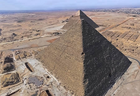
The Giza pyramid complex is an ancient Egyptian necropolis located on the Giza Plateau, approximately 15 kilometers southwest of central Cairo, comprising the three largest pyramids built during the Fourth Dynasty of the Old Kingdom, along with the Great Sphinx, mortuary and valley temples, causeways, boat pits, and hundreds of associated tombs and mastabas. The complex was constructed primarily between approximately 2580 and 2500 BCE as royal burial sites symbolizing the pharaohs' divine power and ensuring their eternal afterlife, reflecting the height of ancient Egypt's architectural and engineering achievements under a strong centralized government.
At the heart of the complex stands the Great Pyramid of Khufu (also known as Cheops), the largest and oldest of the three main pyramids, originally reaching a height of 146.6 meters with a base covering over 13 acres and sides rising at an angle of about 51 degrees 52 minutes; it was built for Pharaoh Khufu around 2580–2560 BCE using an estimated 2.3 million limestone and granite blocks. Adjacent to it is the Pyramid of Khafre, Khufu's son, constructed circa 2558–2532 BCE to a height of 143.5 meters (471 feet), notable for retaining some of its original polished limestone casing at the apex and for being aligned with the Great Sphinx. The smallest of the trio, the Pyramid of Menkaure (Khafre's son), dates to around 2532–2503 BCE and stands at 65 meters (213 feet), marking the transition toward smaller-scale pyramid construction in later dynasties.
The Great Sphinx, a colossal limestone statue measuring 73 meters long and 20 meters high, depicts a mythical creature with a human head and lion's body, likely representing Khafre, and guards the eastern approach to the complex; it was carved from the bedrock of the plateau around 2500 BCE. Supporting structures include solar boat pits near Khufu's pyramid, containing disassembled cedar vessels up to 43 meters long believed to aid the pharaoh's journey in the afterlife, as well as interconnected temple complexes linked by causeways that facilitated rituals and processions. The site also encompasses over 100 mastaba tombs for nobility and officials, underscoring the hierarchical society that supported these monumental projects through skilled labor rather than slavery.
Designated a UNESCO World Heritage Site in 1979 as part of the Memphis and its Necropolis, the Giza complex, whose Great Pyramid is the only surviving ancient Wonder of the World, exemplifies unparalleled Pharaonic innovation in stone architecture, quarrying, and transportation techniques, while serving as a profound testament to ancient Egyptian religious beliefs in immortality and cosmic order. Its enduring mystery—encompassing construction methods, such as possible ramps and levers—continues to drive archaeological research, revealing insights into the Old Kingdom's economic and social organization.
Historical Background
Pre-Giza Settlements
The Maadi culture, flourishing between approximately 4000 and 3500 BCE in the Memphite region south of the Giza plateau, is associated with some of the earliest documented human activity in the area. These semi-nomadic communities constructed light dwellings, including semi-subterranean houses with mudbrick and stone foundations, postholes, and trenches, reflecting a lifestyle adapted to the Nile floodplain and desert fringes. Characteristic pottery included globular vessels with flat bases, narrow necks, and flared rims, often made from calcareous clay influenced by Levantine styles, alongside basalt vessels produced locally.
Evidence of early interactions with the Nile Valley and beyond is evident in trade goods recovered from Maadi sites, such as copper tools including axes, spatulas, fishhooks, and ingots sourced from the Sinai Peninsula, as well as imported Levantine ceramics and artifacts that suggest exchange networks extending to the eastern Mediterranean. Evidence of Maadi culture at Giza includes pottery jars found there, indicating predynastic activity adjacent to the plateau. Predynastic settlements are also evidenced on the nearby floodplain. The associated Maadi-Maadi South cemetery, part of the broader Wadi Digla burial ground, contained over 500 individual pit graves with contracted skeletons, accompanied by sparse grave goods like pottery vessels and shellfish valves, highlighting simple funerary practices.
By around 3500 BCE, the Maadi culture transitioned under influences from the Naqada culture originating in Upper Egypt, leading to the emergence of small farming communities on the Giza plateau and surrounding areas. These groups practiced floodplain agriculture and maintained burial customs involving grave goods such as pottery and stone tools, with Naqada-style ceramics like black-topped and wavy-handled wares appearing in Lower Egyptian contexts, signaling cultural integration and the spread of southern technological and symbolic elements northward. These predynastic activities established patterns of habitation and resource use that underpinned the plateau's role in later Egyptian society.
Fourth Dynasty Context
The Fourth Dynasty of ancient Egypt, spanning approximately 2613–2494 BCE, marked a pinnacle of Old Kingdom prosperity and architectural innovation under a series of powerful pharaohs. Sneferu, the dynasty's founder (c. 2613–2589 BCE), initiated the transition from the step pyramids of the Third Dynasty to true, smooth-sided pyramids through his constructions at Meidum, Dahshur's Bent Pyramid, and the Red Pyramid, laying the groundwork for the Giza monuments. His son Khufu (c. 2589–2566 BCE) continued this evolution by erecting the Great Pyramid at Giza, followed by Khafre (c. 2558–2532 BCE), who built the second Giza pyramid and the Great Sphinx, and Menkaure (c. 2532–2503 BCE), responsible for the smallest Giza pyramid. This progression reflected the dynasty's growing mastery of pyramid design, driven by the pharaohs' ambition to create enduring symbols of their rule.
Central to the Fourth Dynasty's pyramid-building endeavors were deeply ingrained religious beliefs in the afterlife and divine kingship, which positioned the pharaoh as a god incarnate responsible for maintaining cosmic order (ma'at). Egyptians viewed the pharaoh's ka—the vital life force or double—as essential for eternal existence, requiring a monumental tomb to house and sustain it post-mortem through offerings and rituals. Pyramids served as these eternal homes, facilitating the ka's ascent to the divine realm and ensuring the ruler's continued mediation between gods and humanity, a role emphasized in royal iconography and texts from the period. This theological framework not only justified the immense resources devoted to construction but also reinforced the pharaoh's semi-divine status, intertwining state power with spiritual imperatives.
 The dynasty's achievements were underpinned by a highly centralized economy and administration that harnessed Egypt's agricultural surplus and organized labor on an unprecedented scale. With the Nile's annual floods enabling bountiful harvests of wheat and barley, the state maintained granaries and redistributed resources through a bureaucracy of viziers, scribes, and provincial nomarchs overseeing about 35 nomes. This system facilitated trade for essential materials like timber from Lebanon and copper from Sinai, while mobilizing skilled and seasonal workers—primarily farmers during inundation periods—without reliance on slavery, as evidenced by workers' villages and records at Giza. Such organization exemplified the Fourth Dynasty's administrative prowess, channeling national wealth into monumental projects that symbolized unified authority.
Giza's selection as the primary necropolis stemmed from its strategic location on the west bank of the Nile, approximately 17 kilometers northwest of Memphis, the political capital, allowing efficient oversight of construction. The site's raised limestone plateau, an Eocene formation rising approximately 60 meters above the surrounding Nile valley, provided a stable, elevated bedrock ideal for massive structures and offered symbolic prominence, visible across the landscape as a divine perch. Proximity to a now-defunct Nile branch, known as the Ahramat or Khufu arm, further enabled the transport of quarried stone and supplies via boats during flood seasons, linking the plateau directly to regional resources. This combination of logistical, geological, and symbolic advantages made Giza the focal point for the dynasty's funerary legacy.
Core Monuments
Pyramid of Khufu
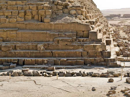
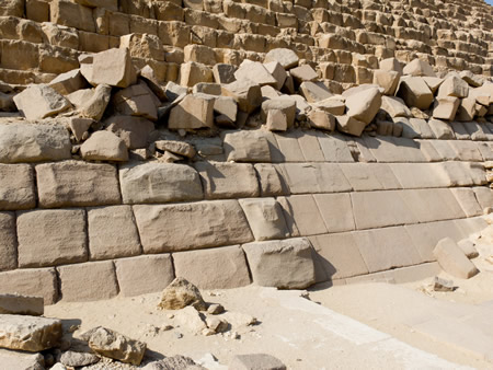
The Pyramid of Khufu, also known as the Great Pyramid, is the largest and oldest of the three main pyramids in the Giza complex, constructed during the Fourth Dynasty around 2580–2560 BCE as the tomb of Pharaoh Khufu. Originally standing at a height of 146.6 meters, it features a square base measuring 230.3 meters on each side, with a total volume of approximately 2.6 million cubic meters. The structure comprises about 2.3 million blocks of limestone and granite, primarily sourced from local quarries on the Giza Plateau for the core limestone blocks and from Aswan over 800 kilometers to the south for the harder granite used in key internal elements. Its exterior was once clad in smooth white Tura limestone casing stones, most of which were removed in later centuries, leaving the underlying stepped core visible today.
The internal layout includes a series of passages and chambers designed for funerary purposes. Visitors enter via a descending passage leading to a subterranean chamber carved into the bedrock below the pyramid's base. An ascending passage connects to the Grand Gallery, a corbelled corridor rising 8.6 meters high and 47 meters long, which provides access to the Queen's Chamber and ultimately the King's Chamber. The King's Chamber, constructed entirely of massive rose granite blocks, measures 10.5 meters long, 5.2 meters wide, and 5.8 meters high, housing a plain granite sarcophagus embedded in the floor that once contained Khufu's remains but was found empty upon modern exploration. Above the King's Chamber lie five relieving chambers to distribute the pyramid's immense weight.
 The pyramid is integrated into a larger funerary complex that includes a mortuary temple adjacent to its eastern face, connected by a causeway to a valley temple near the Nile's ancient floodplain. Five boat pits surround the pyramid, with two on the south side containing disassembled cedarwood solar boats intended for Khufu's journey in the afterlife; one, measuring 43.6 meters long, was excavated intact in 1954. The complex also features three smaller pyramids for Khufu's queens and various mastaba tombs for officials, all aligned with the pyramid's precise orientation to the cardinal points. In March 2025, the ScanPyramids project confirmed the existence of the North Face Corridor, a previously detected void, using multi-modal non-destructive imaging techniques.
Pyramid of Khafre
The Pyramid of Khafre, constructed during the Fourth Dynasty for Pharaoh Khafre (c. 2558–2532 BCE), serves as the second-largest pyramid in the Giza complex, embodying advanced Egyptian engineering and funerary symbolism. Its original height reached 143.5 meters (471 feet), with a square base measuring 215.25 meters (706 feet) per side, resulting in a volume of approximately 2.21 million cubic meters. The pyramid's faces incline at a steeper angle of 53°10' compared to the 51°52' of the neighboring Pyramid of Khufu, contributing to its distinctive profile.
Positioned on elevated bedrock about 10 meters higher than Khufu's pyramid, Khafre's structure creates an optical illusion of superior height, further accentuated by the survival of its smooth Tura limestone casing stones at the apex—the only such remnants on any Giza pyramid. These polished white stones, originally encasing the entire exterior, reflect sunlight and enhance the monument's majestic appearance from afar. The pyramid's core consists of locally quarried limestone blocks averaging 2.5 tons, with heavier granite elements in key areas for durability.
Access to the interior occurs via two northern entrances: an upper one at 11.54 meters above ground level and a lower one at the base, both leading through descending passages reinforced with granite beams to prevent collapse. These passages connect to an ascending corridor and a subsidiary chamber (approximately 10.4 meters by 3.1 meters), possibly intended for storage or ritual items, before reaching the main burial chamber. This chamber, measuring 14.2 meters long, 5 meters wide, and approximately 6.9 meters high with a pointed limestone ceiling, was carved directly into the bedrock and lined with massive granite blocks; it contains a black basalt sarcophagus sunk into the floor, its lid now displaced nearby, underscoring the pharaoh's eternal protection. To the south, three smaller subsidiary pyramids, each about 20–30 meters per side, likely served as burial sites for Khafre's queens, integrating familial commemoration into the complex.
The pyramid forms the core of an elaborate funerary ensemble, including an upper mortuary temple immediately adjacent to its eastern face, built with a limestone core and red granite casing, featuring an open courtyard, statue niches, and alabaster-floored sanctuary for offerings to the king's ka (spirit). A raised causeway, lined with reliefs and incorporating the Great Sphinx as a guardian along its path, links this temple to the lower valley temple at the complex's edge, a well-preserved structure with T-shaped granite pillars and niches that once held over 20 statues of the pharaoh. This valley temple connected to a harbor basin on the ancient Nile floodplain, enabling Nile boat processions to deliver the royal mummy directly for ceremonial rites, as evidenced by archaeological traces of water channels.
Pyramid of Menkaure
The Pyramid of Menkaure, the smallest of the three principal pyramids at Giza, was constructed for the Fourth Dynasty pharaoh Menkaure c. 2532–2503 BCE. It originally stood 65 meters tall with a square base measuring 103.4 meters on each side, significantly smaller in scale than its predecessors and reflecting a possible shift in resources or priorities during Menkaure's reign. The structure features a core built from local limestone blocks, with the lower 16 to 17 courses encased in red granite quarried from Aswan, while the upper portions were planned for white Tura limestone casing that would have given it a polished, gleaming appearance similar to the nearby pyramids. This unique combination of materials highlights advanced quarrying and transportation techniques, as the heavy granite blocks were floated down the Nile from southern Egypt. In November 2025, researchers using electrical resistance tomography detected two anomalies within the pyramid, potentially indicating hidden chambers or features.
Internally, the pyramid contains a simple layout with a north-facing entrance leading to a descending passage that slopes downward for approximately 22 meters before reaching an antechamber and the main burial chamber hewn directly into the bedrock beneath the pyramid's center. The burial chamber measures about 6.4 by 3.8 meters and is lined with granite blocks, providing a secure and symbolically significant resting place. Adjacent to the main pyramid are three smaller subsidiary pyramids, intended for royal consorts, though their exact occupants remain uncertain; the easternmost (G III-a) is attributed to Queen Khamerernebty II, wife of Menkaure, while the others lack definitive inscriptions or remains. These subsidiary structures, each about 20 to 30 meters tall, were also partially cased in granite and limestone, underscoring the familial focus of the necropolis.
 The pyramid forms part of a broader mortuary complex, including an eastern mortuary temple for rituals and offerings, connected by a causeway—roughly 600 meters long—to a valley temple near the ancient Nile floodplain, which facilitated processions and served as an entry point for the deceased's ka. Evidence of the pyramid's incomplete state is evident in the irregular upper courses, unfinished casing, and untrimmed base, likely resulting from Menkaure's untimely death after a reign of about 18 years, which halted construction before full completion. In the medieval period, Sultan Al-Aziz Uthman of the Ayyubid dynasty ordered its partial dismantling in 1196 CE to remove stones for other projects, but the effort was abandoned after eight months due to the immense cost and labor, succeeding only in stripping some lower granite facing. Modern restoration efforts, including 19th-century explorations by British officers and ongoing conservation by Egyptian authorities since the 20th century, have aimed to stabilize the structure and protect remaining casing stones, though recent proposals to reinstall granite blocks sparked debate over authenticity.
Great Sphinx of Giza
The Great Sphinx of Giza is a monumental limestone statue portraying a mythical sphinx—a creature with the body of a lion and the head of a human or divine figure—carved directly from the bedrock of the Giza plateau. Measuring approximately 73 meters (240 feet) in length from paws to tail and standing 20 meters (66 feet) tall at the shoulders, it dominates the landscape east of the Pyramid of Khafre, serving as a symbolic guardian. The statue's proportions feature a relatively small head relative to its elongated lion body, emphasizing the majestic, recumbent form that evokes power and protection in ancient Egyptian iconography. Traces of red pigment on the face indicate that the Sphinx was originally painted, likely in vibrant colors typical of Old Kingdom monumental art, though much has been lost to weathering.
Constructed around 2500 BCE during the Fourth Dynasty, the Sphinx was hewn as a single-piece monolith from a natural limestone outcrop, with the surrounding U-shaped ditch functioning as both the carving site and a quarry that supplied core blocks for nearby structures. Later additions included masonry blocks to form the paws, chest, and flanks, restoring and enhancing the original bedrock form after initial erosion or damage. Geological analysis of the bedrock layers—comprising Member III for the head and Member II for the body—confirms the use of local Moqattam Formation limestone, with blocks up to 100 tons quarried from the enclosure for construction. This integrated approach links the Sphinx directly to the broader Giza necropolis engineering efforts under Pharaoh Khafre.
Scholars widely attribute the Sphinx to Khafre, interpreting the facial features as a portrait of the pharaoh in the guise of Horus, the falcon-headed god of kingship, symbolizing divine authority over the afterlife. Alternative theories propose an earlier origin, possibly as a representation of Anubis, the jackal-headed god of embalming and the necropolis, based on the statue's eastward orientation toward the rising sun and its protective role, though this remains debated among Egyptologists. The monument's prominent erosion patterns, particularly vertical fissures on the body and enclosure walls, fuel ongoing discussions: mainstream views attribute them to wind and sand abrasion over millennia in the arid post-construction environment, while a minority argues for precipitation-induced water erosion suggesting a pre-dynastic date before 3000 BCE.
The Sphinx is closely associated with the Sphinx Temple, an unfinished structure immediately east of the statue built from the same quarry blocks, featuring large limestone cores without the granite casing seen in other Giza temples. This temple likely served ritual purposes linked to the Sphinx's symbolic role. The enclosure wall, carved from the quarry ditch walls, surrounds the statue on three sides, forming an amphitheater-like space that frames the Sphinx as a focal point of the necropolis, with evidence of later repairs and additions from the 18th Dynasty onward.
Associated Temples and Tombs
The tomb of Khentkaus I, located south of the Great Sphinx in the Central Field at Giza, features a distinctive step-pyramid-like superstructure built on a rectangular mastaba base carved into the bedrock and lined with white limestone blocks measuring 46.2 meters long and 25 meters wide. The structure consists of two steps, the lower one 10 meters high and the upper one 7 meters high, surrounded by a T-shaped funerary temple, causeway, and valley temple enclosed within a stone wall; the burial chamber lies beneath in the bedrock, accessed via a northern corridor leading south to a room 8.4 meters long, 3.6 meters wide, and 3.4 meters high, where an empty sarcophagus was found, indicating ancient robbery. Dating to circa 2490 BCE in the late Fourth Dynasty or early Fifth Dynasty, the monument's design and the bearer's titles—such as "mother of the king of Upper and Lower Egypt" and potentially kingly epithets—have sparked debate among scholars over whether Khentkaus I was a queen regent or briefly ruled as a king herself, with some interpreting her iconography as intentionally ambiguous to signify royal authority. Excavations revealed fragments of statues in a serdab adjacent to the burial chamber and reliefs depicting offering scenes in the temple, underscoring her high status and funerary rituals.
The valley temples associated with the Giza pyramids served as entry points for funerary processions from the Nile, facilitating the king's ritual purification and mummification before ascent to the mortuary temples. Khufu's valley temple, constructed primarily of massive Aswan granite blocks with a T-shaped layout, once housed statues of the pharaoh, including potential diorite figures symbolizing his eternal presence, though much of the structure was dismantled in antiquity for reuse. Khafre's valley temple, built from megalithic limestone and granite near the Sphinx, features a deep basin connected to an ancient harbor basin via a causeway, enabling Nile boat processions to deliver the royal mummy directly for ceremonial rites; approximately 24 niches originally held colossal diorite and greywacke statues of the king, many now in museums, emphasizing his divine protection by Horus.
Among the tombs of royal family members, Prince Kawab's mastaba (G 7120), east of Khufu's pyramid, stands as an unfinished monument reflecting the prince's premature death during his father's reign; the large limestone structure includes a chapel with prepared spaces for reliefs and a serdab for statues, but construction halted abruptly, leaving walls incomplete and no burial goods, highlighting the urgency of elite interments at Giza. Nearby, the tomb of Hetepheres I, Khufu's mother (G 7000 X), consists of a hidden subterranean chamber beneath her intended mastaba, discovered intact in 1925 and containing a cache of exquisite jewelry—including silver bracelets inlaid with turquoise, lapis lazuli, and carnelian—along with gilded furniture and vessels, suggesting the tomb was a symbolic reburial of her effects after her original interment elsewhere.
Adjacent to Khufu's pyramid lie five boat pits, symbolic vessels for the pharaoh's solar journey in the afterlife, with two containing disassembled cedar ships; the most famous, excavated in 1954 from Pit 1, measures 43.6 meters long and 5.9 meters wide, meticulously restored without metal fasteners using traditional mortise-and-tenon joints and displayed in the adjacent Giza Solar Boat Museum since 1985.
Architectural and Symbolic Design
Purpose and Funerary Role
The Giza pyramid complex served as a grand necropolis embodying the ancient Egyptian belief in divine kingship, where pharaohs were seen as living gods destined for eternal rule in the afterlife. This funerary landscape was designed to facilitate the ruler's transition to immortality, ensuring the continuity of cosmic order (ma'at) through monumental architecture that linked the earthly realm to the divine. The complex's layout, centered on the pyramids of Khufu, Khafre, and Menkaure, reflected a theological framework where the pharaoh's death mirrored the sun god Re's nightly journey and resurrection, symbolizing renewal and eternal dominion.
Elements of the Giza pyramids' design anticipated motifs later elaborated in the Pyramid Texts of the Fifth and Sixth Dynasties, such as the concept of a stairway to heaven enabling the pharaoh's ascent to the stars. Although the texts themselves postdate Giza's construction, the pyramids' stepped precursors, like Djoser's at Saqqara, explicitly symbolized this ascent, evolving into the smooth-sided forms at Giza that evoked rays of sunlight descending from the sky. Central to this symbolism was the benben stone, a conical or pyramidal artifact representing the primordial mound of creation in Heliopolitan theology, from which the creator god Atum emerged to initiate the world. The pyramid's apex, or pyramidion, often capped with electrum to catch the sun's rays, embodied this benben, signifying the pharaoh's rebirth as a creator akin to Atum.
In ancient Egyptian cosmology, the soul comprised multiple aspects, notably the ka—a vital life force inherited from the gods and passed to successors—and the ba, a mobile manifestation of power enabling travel between worlds. The pyramids functioned as eternal residences for the ka, providing a stable, protected space where it could receive offerings of food and incense to sustain the pharaoh's vitality indefinitely. Adjacent mortuary temples and causeways served as sites for ongoing cult worship, where priests performed rituals to nourish the ba, allowing it to reunite with the ka and achieve resurrection as an akh (transfigured spirit). This dual provision ensured the deceased king's active participation in the afterlife, as seen in early Old Kingdom practices where the ka was invoked in royal decrees and tomb inscriptions.
Under the Fourth Dynasty, solar theology profoundly influenced the Giza complex, integrating the pharaoh with Re's daily journey across the sky and into the underworld. The pyramids' eastward-facing temples aligned with the rising sun, symbolizing the king's identification with Re-Atum, whose resurrection at dawn mirrored the pharaoh's hoped-for revival. Resurrection motifs, drawn from the bennu-bird (phoenix) perched on the benben, underscored themes of emergence from chaos, with the pharaoh rising as a solar deity to combat cosmic threats like the serpent Apophis. This theology elevated the ruler as a mediator between gods and humans, his eternal life guaranteeing the Nile's fertility and societal harmony.
Beyond theology, the Giza complex fulfilled a social function by legitimizing pharaonic power and fostering state unity. The sheer scale of the monuments demonstrated the king's divine mandate, mobilizing resources across Egypt to affirm centralized authority and integrate provincial elites through shared participation in the royal cult. By housing the pharaoh's eternal essence, the pyramids reinforced the ideology of divine kingship, portraying the ruler as the linchpin of order and prosperity, thus binding the populace in loyalty to the throne.
Astronomical Orientations
The pyramids of the Giza complex exhibit precise cardinal alignments to true north, with the Great Pyramid of Khufu oriented to within approximately 3 arcminutes of deviation, as measured by Flinders Petrie in the late 19th century. This remarkable accuracy, also evident in the pyramids of Khafre and Menkaure at similar levels of precision, is attributed to ancient Egyptian astronomical techniques involving observations of circumpolar stars, such as the simultaneous culmination of Kochab (Beta Ursae Minoris) and Mizar (Zeta Ursae Majoris) around 2467 BCE, which would have provided a reliable reference for north during the Fourth Dynasty. Such stellar methods allowed surveyors to establish baselines for the pyramid bases before construction, reflecting the Egyptians' advanced understanding of celestial mechanics.
Internal features of the Great Pyramid further demonstrate intentional astronomical orientations, particularly its narrow shafts extending from the King's and Queen's Chambers. These shafts, proposed by Virginia Trimble and Alexander Badawy in 1964, align with significant stars visible around 2500 BCE: the southern shafts target the belt stars of Orion (specifically Alnitak and Mintaka) and Sirius (Alpha Canis Majoris), while the northern shafts point toward circumpolar stars like Thuban (Alpha Draconis) and Kochab. This configuration suggests a deliberate incorporation of stellar symbolism into the pyramid's design, linking the structure to the eternal cycles of the sky and the resurrection of the pharaoh, akin to associations with solar deities like Ra. The Orion Correlation Theory, advanced by Robert Bauval in 1989, extends this idea by positing that the spatial arrangement of the three main pyramids mirrors the layout of Orion's Belt stars as they appeared in the southern sky circa 10,500 BCE, though this remains a debated hypothesis among Egyptologists due to challenges in matching precessional shifts and archaeological context.
The Great Sphinx and its enclosure also contribute to the site's astronomical framework, with alignments that frame celestial events tied to the solar calendar. On the equinoxes, the sun sets in precise alignment between the Sphinx and the Pyramid of Khafre, illuminating the temple complex and potentially symbolizing the balance of day and night in Egyptian cosmology. From the perspective of the enclosure, this positioning would have allowed observers to witness the equinox sunrise rising directly behind the pyramids to the east, enhancing the site's role in tracking seasonal transitions essential for Nile flood predictions and agricultural rites.
Debates persist regarding the exact methods achieving these orientations, with scholars proposing the use of the merkhet—a plumb-line sighting tool combined with a palm-rib timekeeper—for measuring stellar transits and solar positions with high precision. While the merkhet's application is inferred from later New Kingdom texts and artifacts, its potential in Fourth Dynasty surveying underscores the empirical sophistication of Egyptian astronomy, enabling alignments that surpassed many contemporary civilizations.
Engineering and Construction Techniques
The construction of the Giza pyramid complex relied on extensive quarrying operations, primarily sourcing local limestone from the Giza plateau itself. The core blocks were extracted from nearby quarries to the south and east of the pyramids, where the bedrock was cut using copper chisels and stone hammers to shape the roughly hewn stones. For the outer casing, finer white limestone was quarried from Tura, across the Nile, prized for its durability and aesthetic quality. Granite, used for internal chambers and portcullises, came from Aswan quarries approximately 800 kilometers south, with blocks transported by boat along the Nile River during the annual flood season to facilitate easier movement.
Handling and positioning the blocks involved basic yet effective tools and methods adapted to the scale of the project. Limestone core blocks averaged about 2.5 tons each, while some granite elements exceeded 50 tons, requiring copper tools for cutting, along with wooden levers, rollers, and sledges lubricated with water to reduce friction during transport overland. Workers likely dragged blocks on sledges pulled by teams using ropes made from papyrus or leather, with rollers placed beneath to aid movement across the plateau. To elevate blocks up the pyramid's height, various ramp systems were employed, including straight ramps extending from the base, wrapping or zigzag ramps around the sides, and internal spiral ramps proposed by engineer Jean-Pierre Houdin to minimize material use and allow construction to proceed layer by layer.
The workforce for the Khufu pyramid, the largest at Giza, is estimated at 20,000 to 30,000 laborers over roughly 20 years, organized into rotating teams that swelled during the Nile's inundation when agricultural work paused. Archaeologist Mark Lehner’s excavations of the workers' infrastructure suggest a core group of skilled masons and haulers, supplemented by seasonal corvée labor from across Egypt, coordinated through a hierarchical system of overseers to achieve the project's pace.
Key innovations included the precise jointing of stones, with casing blocks fitted so tightly that gaps averaged less than 0.5 millimeters, achieved through on-site trimming and minimal mortar use to ensure structural integrity. The pyramids were originally sheathed in smooth Tura limestone casing stones, polished to reflect sunlight and create a gleaming appearance, though most were later quarried away in medieval times for use in Cairo's buildings. These techniques demonstrated advanced surveying and leveling capabilities, contributing to the complex's renowned alignment precision. Recent studies have identified a now-buried branch of the Nile River, known as the Ahramat Branch, that extended close to the Giza plateau, likely facilitating the transport of heavy stones by boat during the annual flood around 4,500 years ago (2022). Additionally, a 2025 study proposes that the Great Pyramid incorporated an internal pulley-like system using counterweights on sliding ramps, utilizing features such as the Grand Gallery to efficiently lift blocks weighing up to 60 tons.
Community and Labor
Workers' Settlement
The Heit el-Ghurab settlement, located approximately 400 meters south of the Great Sphinx on the Giza Plateau near the Wall of the Crow, served as the primary residential and operational hub for the laborers constructing the pyramids during the Fourth Dynasty (c. 2550–2490 BCE). This approximately 7-hectare site featured a structured layout including long barrack-like galleries for housing, large-scale bakeries equipped with bread molds, fish-processing installations, craft workshops, kitchens, warehouses, and administrative buildings, reflecting an organized community designed to support intensive construction activities.
Archaeological evidence indicates the settlement accommodated 10,000 to 20,000 individuals, comprising skilled workers, overseers, craftsmen, and support staff, as inferred from the scale of provisioning facilities and faunal remains suggesting a substantial population requiring organized food distribution. Discoveries such as graffiti inscribed on pottery and walls, including references to work gangs like the "Friends of Khufu," highlight the structured team-based labor system and a sense of group identity among the builders. Additionally, analysis of skeletal remains from the adjacent workers' cemetery reveals evidence of medical intervention, with healed limb fractures, successful amputations, and treated skull injuries indicating access to splinting, surgery, and care for work-related traumas.
Daily life centered on mass-produced staples distributed as wages, including bread baked in molds and beer brewed in large vats, which formed the core of the workers' diet and compensation alongside occasional meat from sheep, goats, and cattle. Fish, primarily Nile species like perch, were processed on-site and sourced from the nearby Nile River, underscoring the settlement's integration into broader supply networks to sustain the workforce. The labor was organized through a corvée system, with much of the workforce mobilized seasonally during the Nile inundation when agricultural duties were minimal, as confirmed by ongoing excavations as of 2025.
Supporting Infrastructure
The supporting infrastructure for the Giza pyramid complex encompassed quarries, harbors, canals, workshops, and temporary construction aids that facilitated the logistics of stone procurement, transport, and processing during the Old Kingdom, particularly under the Fourth Dynasty (c. 2580–2565 BCE for Khufu). Local limestone quarries on the Giza Plateau provided the bulk of the core material, while distant sources supplied specialized stones, all integrated through a network of waterways and production sites.
The primary quarries were situated on the southern and eastern edges of the Giza Plateau, where open-cut pits yielded high-quality limestone for pyramid cores and some casing. These southern pits, visible adjacent to Khafre's pyramid, featured trenching and undercutting techniques, with tool marks from copper or bronze chisels indicating systematic extraction up to 30 meters deep. Approximately 2.76 million cubic meters of limestone were removed for Khufu's pyramid alone, leaving a horseshoe-shaped depression south of the structure. For harder stones, granite and granodiorite were sourced from Aswan, over 800 kilometers south, where quarries produced blocks weighing up to 80 tons for burial chambers and temple elements; these were transported northward via large wooden barges on the Nile River, likely during seasonal floods to ease navigation.
Harbors and canals formed a critical waterway system, leveraging the Nile's annual inundation (c. August–November) to deliver materials directly to the plateau. A major harbor basin, identified east of Khufu's Valley Temple, measured about 400 by 475 meters and reached depths of up to 3 meters during floods, accommodating boats up to 9 meters long for unloading limestone from Tura and granite from Aswan. A T-shaped central canal, dredged westward from the Nile toward the Sphinx and Khafre's Valley Temple, connected to additional basins, enabling efficient stone transport over distances of several kilometers. The Wadi al-Jarf papyri, discovered at a Red Sea port and dated to Khufu's reign (c. 2575 BCE), document these operations through logs of an official named Merer, who oversaw crews shipping limestone blocks via inundation-season voyages to Giza's construction site.
Workshops for tool production and stone processing were concentrated near the valley temples and quarries, supporting on-site fabrication. Arsenical copper tools—chisels, adzes, and saws alloyed with trace arsenic for hardness—were forged from Eastern Desert ores, with remnants analyzed from Giza contexts showing use in cutting limestone and woodworking. Stone-cutting areas adjacent to the valley temples featured pounding stones, dolerite hammers, and copper implements for shaping blocks, as evidenced by experimental recreations matching quarry tool marks. These facilities produced thousands of tools annually, essential for the precision required in pyramid assembly.
Remnants of construction ramps, primarily earthen structures built from mudbrick, tafla (clay), and limestone chips, survive in traces around the pyramids, indicating their role in block elevation. Post-construction, these ramps were dismantled, with materials recycled as fill into pyramid cores or dumped into quarries to restore the landscape, as suggested by debris layers in the southern quarry basin. Such practices minimized waste and facilitated site cleanup after the monuments' completion.
Necropolis Layout
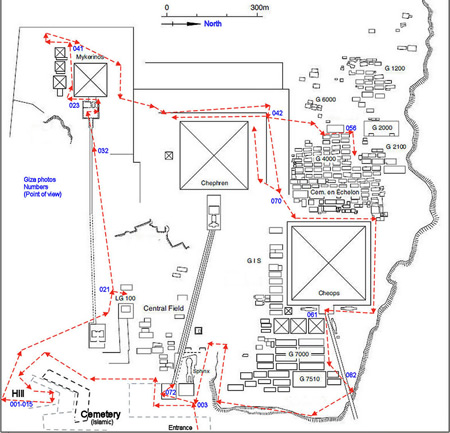
Western Cemetery
The Western Cemetery, situated immediately west of the Great Pyramid on the Giza Plateau, serves as the principal burial ground for elite members of the royal family and high-ranking officials during the Fourth Dynasty. This expansive field encompasses multiple sub-cemeteries, such as the G 4000, G 2000, G 2100, and G 6000 areas, featuring over 30 mastabas arranged in systematic rows along north-south streets and east-west avenues to facilitate processions and maintenance. These layouts reflect deliberate planning to accommodate hierarchical burials close to the royal pyramids, with early "nucleus" groups forming compact clusters that expanded as space allowed, underscoring the cemetery's role in the necropolis's overall organization.
Among the key tombs, the joint mastaba of Queen Hetepheres II (G 7110-7120), daughter of Khufu, stands out for its proximity to the pyramid and the discovery of artifacts including fragments of gold jewelry, ivory furniture, and a limestone sarcophagus, though the tomb had been robbed in antiquity. Adjacent to it, the mastaba of Prince Kawab (G 7120), eldest son of Khufu, remains unfinished, with its chapel and burial shaft abruptly halted, likely due to Kawab's untimely death during his father's reign; the structure includes a serdab for statues and an offering chapel with reliefs depicting royal offerings. These tombs highlight the privileges afforded to immediate royal kin, with inscriptions bearing titles like "Eldest King's Son" and emphasizing familial ties to the pharaohs.
Architecturally, the Western Cemetery features a mix of built mastabas constructed from limestone blocks and rock-cut elements carved into the bedrock, often with L-shaped or pillared chapels for cultic activities. Serdab chambers, small sealed rooms adjacent to the chapel, housed life-sized statues of the deceased to receive offerings on their behalf, as seen in tombs like G 6020 of Iymery, where slots allowed food and incense to pass through. Offering tables, typically made of limestone or alabaster and inscribed with hieroglyphic formulas invoking bread, beer, and oxen, were placed in chapel niches to sustain the ka (spirit) eternally; examples include a 68 x 48 cm table from G 6030. Many chapels boast painted reliefs depicting daily life, estate offerings, and processions, such as the vibrant scenes in G 2097 of Iymery, illustrating butchers and scribes to invoke prosperity.
Burials in the Western Cemetery date primarily to circa 2550–2490 BCE, spanning the reigns of Khufu and Khafre in the Fourth Dynasty, and embody the administrative hierarchy through the occupants' titles—ranging from royal princes and princesses to viziers like Hemiunu (G 4000) and overseers of royal works. These inscriptions and tomb sizes (e.g., G 4000 at 52 x 28 m) denote status levels, with larger mastabas for top officials managing pyramid construction and state resources, thereby linking the cemetery to the broader funerary and societal structure of the Old Kingdom. In 2024, ground-penetrating radar and electrical resistivity tomography surveys detected an L-shaped underground anomaly approximately 10 by 15 meters in size and 0.5 to 2 meters deep within the Western Cemetery, potentially indicating an entrance to a deeper structure or tomb, suggesting further unexplored elements of the necropolis layout.
Eastern Cemetery
The Eastern Cemetery, also known as Cemetery G 7000 or the East Field, lies directly east of Khufu's Great Pyramid and consists of a compact arrangement of over ten mastaba tombs primarily constructed for elite members of the Fourth Dynasty royal family and officials. These mastabas, often built as double or twin structures in staggered rows, form a distinct burial zone that emphasizes proximity to the pyramid's eastern facade and the adjacent causeways, allowing for ceremonial processions and offerings. This layout reflects the necropolis's overall hierarchy, where proximity to the pharaoh's tomb signified status among queens, princes, and high-ranking administrators.
A standout feature is the mastaba of Queen Meresankh III (G 7530-7540), a granddaughter of Khufu and likely wife of Khafre or a royal prince, which combines an above-ground chapel with a subterranean rock-cut chamber. The chapel's cruciform design includes finely carved false door reliefs depicting the queen receiving offerings, alongside palace-façade motifs and scenes of daily life that highlight her status and the era's artistic sophistication. Burials in the cemetery include those of viziers such as Ankh-haf (G 7510), who served under Khafre, and various priests associated with the pyramid cults, illustrating the integration of administrative and religious elites in funerary practices.
Many tombs show signs of ancient plundering, with disturbed burial chambers and scattered remains indicating robbery shortly after interment, though some yielded artifacts reflecting advanced craftsmanship and international trade. Notable finds include ivory labels used for cataloging grave goods, copper adze blades and model dishes as symbolic offerings, and fragments of limestone servant statues, which underscore the period's metallurgical expertise and ritual customs. These items, often placed in burial kits, provide evidence of the economic networks supporting the Giza construction projects.
The cemetery's development occurred mainly after Khufu's reign, with peak activity during the Khafre-Menkaure era (c. 2520–2472 BCE), as later dynasty members shifted burials eastward to accommodate expanding royal and elite commemorations. This post-Khufu chronology is evident in architectural styles and inscriptions, marking a transitional phase in the necropolis's use before later dynasty extensions.
Other Fields
The peripheral cemeteries of the Giza pyramid complex, known as the Central Field, South Field, and Cemetery GIS, represent outlying burial areas that accommodated officials, princes, and diverse social strata beyond the core elite zones of the Western and Eastern Cemeteries. These fields, developed primarily during the Fourth Dynasty with some later reuse, feature a mix of mastaba tombs, rock-cut structures, and shaft burials, reflecting the expanding administrative and familial networks supporting the royal pyramid projects. Artifacts such as pottery vessels and administrative seals recovered from these sites indicate burials spanning multiple ranks, from high officials to lower administrators, providing insights into the social diversity of the Old Kingdom community at Giza.
The Central Field, situated between the causeways of the Khafre and Menkaure pyramids and originally part of a quarry area, contains mastabas of mid-to-high-ranking officials from the Fourth Dynasty. Excavated largely by Selim Hassan between 1936 and 1939 as part of the Egyptian Antiquities Service efforts, the field includes built and rock-cut mastabas with associated chapels and burial shafts designed for funerary offerings and cult activities. Notable examples include mastabas with reliefs depicting daily life scenes and statue niches, highlighting the field's role in housing bureaucratic elites linked to the pyramid administration. Other tombs in the area, such as those in the G 8000 and G 9000 series, exhibit similar architectural elements, with limestone facades and internal serdabs for statues. A representative example is the mastaba of Prince Sekhemkare (G 8154), a rock-cut structure featuring relief-decorated walls in its chapel rooms, where the prince is depicted with his family and titles such as "Eldest King's Son" and "Vizier"; the tomb includes two shafts and emphasizes familial piety through inscribed false doors.
Further south, the South Field extends beyond the Menkaure pyramid and comprises smaller mastabas dating mainly to the Fourth Dynasty, with some earlier and later intrusions. This area, less densely packed than the central zones, was explored during broader Giza surveys by the Harvard University-Boston Museum of Fine Arts Expedition in the early 20th century and later by Hassan. The tombs here are predominantly modest rock-cut mastabas with simple chapels and single shafts, serving princes and officials associated with Menkaure's reign. A representative example is the mastaba-tomb of Queen Khentkaus I (G 8400), a large structure with a chapel featuring reliefs and inscriptions denoting her high status, possibly as a king or queen regent; the tomb includes multiple shafts and underscores connections to royal support personnel. Pottery and sealing artifacts from these burials suggest practical administrative functions, underscoring the field's connection to royal support personnel.
Cemetery GIS, positioned along the southern side of the Khufu pyramid and extending as a continuation of the Eastern Cemetery layout, occupies the northern periphery of the broader southern burial zones at Giza. Developed during the late Fourth Dynasty, particularly under Khafre and Menkaure, the site features a linear arrangement of stone mastabas and rock-cut tombs, excavated by teams including Hermann Junker and the Harvard-MFA Expedition. These structures include multi-room chapels with iconographic reliefs and deep shafts, accommodating officials like Khaemnefert and Niankhre, whose titles reflect roles in royal oversight. Evidence of Middle Kingdom reuse is evident in secondary burials and modifications to some rock-cut tombs, such as the addition of later coffins and offerings, indicating the site's enduring significance into the 12th Dynasty. Artifacts like inscribed seals and ceramic vessels from these contexts reveal a range of social ranks, from priests to scribes, distinct from the more uniform elite patterns in the main Western Cemetery.
Builder Tombs and Mastabas
The builder tombs and mastabas at the Giza pyramid complex are primarily located along the eastern and southern edges of the plateau, distinct from the elite royal cemeteries. These include the Cemetery en Echelon, a hillside area approximately 400 meters south of the Sphinx, which features rows of simple pit graves arranged in a skewed, echelon-like pattern. Excavations in this region, conducted by teams led by Zahi Hawass and Mark Lehner, have uncovered over 600 graves in a lower cemetery and additional tombs in an upper area west of the Khufu Pyramid.
These tombs are characterized by shallow burial shafts, typically two to three feet deep, often lined with mud-brick or fieldstone and covered by simple superstructures such as stepped domes, beehive shapes, or miniature mastabas with false doors. Grave goods are minimal, consisting of everyday items like pottery, bread molds, tools, beads, and occasional animal bones, reflecting the modest status of the deceased. Inscriptions, though rare in the lower tombs, provide evidence of organized labor guilds, with crude hieroglyphs on some false doors indicating group affiliations or protective curses.
Skeletal remains from these burials reveal the physical toll of pyramid construction, with high rates of injuries including fractures to the arms (ulna and radius), legs (fibula), skull trauma, and spinal wear from heavy lifting and repetitive labor. Two cases of amputation were noted, one individual surviving 14 years post-surgery, suggesting access to medical care. The remains show an average lifespan of 30-35 years for men and lower for women, likely due to childbirth risks, yet isotopic analysis indicates a relatively skilled diet supplemented by village provisions of meat, bread, and beer.
Social hierarchies among the builders are evident from titles inscribed in the tombs, such as "overseer of the side of the pyramid," "director of the king's work," and "overseer of builders," pointing to structured teams or phyles that managed labor divisions. These inscriptions, found on false doors or statue bases (e.g., those of the carpenter Inty-Shedu), highlight roles in construction, craftsmanship, and oversight, underscoring a conscripted but respected workforce rather than slaves. The equal representation of male and female burials, often in fetal positions within wooden coffins, further illustrates family-oriented communities tied to the pyramid projects.
Underground Features
Shafts and Passages
The Giza pyramid complex features a network of descending passages primarily designed for access to subterranean chambers beneath the main pyramids. In Khufu's Great Pyramid, the descending passage extends approximately 105 meters from the northern entrance, descending at an angle of about 26 degrees through the bedrock to reach the unfinished subterranean chamber roughly 30 meters below the base. This corridor, roughly 1.1 meters wide and 1.2 meters high, was constructed with precise corbelled roofing in sections to support its length and slope. Similar descending passages are present in the pyramids of Khafre and Menkaure, adapted to each structure's scale; Khafre's passage measures about 28 meters, leading directly to a burial chamber cut into the rock, while Menkaure's is around 31 meters, also terminating in a bedrock chamber. These passages facilitated funerary processions and the placement of burial goods during construction.
In the 19th century, British explorers Colonel Richard William Howard Vyse and Captain Alexander J. Campbell undertook extensive probes into the pyramid structures to uncover potential hidden chambers. Using gunpowder blasts, they created exploratory tunnels through the core masonry, some reaching depths exceeding 15 meters (50 feet), though many yielded no significant discoveries and caused structural concerns. These efforts, conducted between 1837 and 1838, targeted areas suspected of containing undiscovered voids but primarily revealed the pyramids' internal solidity.
The underlying limestone bedrock of the Giza plateau is characterized by natural fissures and cracks formed by geological processes, which ancient builders encountered during excavation. Evidence indicates that some of these fissures were integrated into passage alignments or deliberately sealed with limestone blocks and mortar to prevent collapse and ensure the stability of subterranean features. Such adaptations highlight the engineers' response to the plateau's variable geology.
Interactions with the local water table posed challenges during the creation and early use of lower-level features. Subterranean chambers and passages occasionally flooded due to groundwater seepage, particularly in areas below the plateau's water level, prompting the use of drainage channels or abandonment of deeper excavations in certain pyramids. Historical accounts and modern hydrological studies confirm that the Nile's proximity contributed to these issues, influencing the final design of accessible lower spaces.
Osiris Shaft
The Osiris Shaft is a deep subterranean structure located beneath Khafre's causeway on the Giza Plateau, approximately halfway between the Great Sphinx and Khafre's funerary temple. First noted in ancient accounts by Herodotus in the 5th century BCE, the shaft was systematically excavated in the 1930s by Egyptian archaeologist Selim Hassan during his work at Giza. Hassan's efforts revealed the upper levels but were hampered by flooding in the lower chamber, which repeatedly refilled despite pumping attempts over several years. In 1999, Zahi Hawass led a further excavation that fully explored the waterlogged base, confirming the site's multi-level design and yielding additional artifacts.
The shaft descends approximately 30 meters into the bedrock, comprising three distinct levels connected by narrow passages. The first level, reached after about 9.6 meters, consists of an empty chamber. The second level, at around 20 meters depth, features a central chamber (B) with six side chambers (C through H), each containing a sarcophagus—some made of granite and others of basalt—along with niches for burials. The third and deepest level, at 30 meters, includes a main chamber partially filled with water, surrounding a central basalt sarcophagus supported by four pillars and encircled by a moat-like feature. Sarcophagi across these levels date from the New Kingdom (18th–20th Dynasties, ca. 1550–1070 BCE) through the Late Period (26th Dynasty, ca. 664–525 BCE) and into the Ptolemaic and Roman eras (ca. 305 BCE–395 CE), indicating prolonged use as a burial site.
Excavations have uncovered a range of artifacts reflecting the shaft's extended history of ritual use, including ushabti figurines from the 26th Dynasty, canopic jars, scarabs, and amulets depicting Osiris, djed pillars, and Atef plumes. Human remains, pottery shards, and beads were also found within the sarcophagi and chambers, spanning from the 6th Dynasty (Old Kingdom, ca. 2345–2181 BCE) to Roman times. At the base, the persistent groundwater—likely connected to the Nile aquifer—has preserved some organic materials but complicated recovery efforts.
Scholars interpret the Osiris Shaft as a sacred site dedicated to the cult of Osiris, the god of the underworld and resurrection, possibly serving as a symbolic tomb or cenotaph for the deity. Its design and watery depths evoke the mythical Duat (underworld), with the flooding linked to Osiris's association with the Nile's annual inundation, symbolizing renewal and rebirth in ancient Egyptian rituals. The structure may represent the "Shetayet" (secret place) of Sokar-Osiris at Rosetau (a name for the Giza necropolis), facilitating ceremonies for the deceased's regeneration.
Recent claims as of 2025 suggest possible additional underground structures or connections beneath the Giza plateau, including rediscovered shafts potentially linked to the Osiris Shaft, though these remain debated among experts and subject to ongoing research.
Later Historical Phases
New Kingdom Reuse
During the 18th Dynasty, Pharaoh Thutmose IV (r. c. 1400–1390 BCE) initiated notable restoration efforts at the Giza complex, focusing on the Great Sphinx. The Dream Stele, erected between the Sphinx's forepaws, records that Thutmose IV cleared encroaching sand from the monument after a dream in which the Sphinx—identified as the solar deity Harmakhis (Horus in the Horizon)—promised him kingship in exchange for its liberation. This intervention not only preserved the Sphinx but also reinforced its association with solar worship, portraying it as a divine protector aligned with royal legitimacy and the sun god Ra.
In the 19th Dynasty, Ramesses II (r. c. 1279–1213 BCE) further engaged with Giza's monuments through restorative and dedicatory actions. He erected two stelae between the Sphinx's paws, commemorating repairs and affirming his piety toward the ancient structures, alongside other inscribed artifacts found in the vicinity. Additionally, Ramesses II incorporated granite shrines and statues of himself into Khafre's valley temple, repurposing and enhancing the Old Kingdom architecture to integrate it into his own imperial cult narrative.
New Kingdom activity at Giza also involved cult continuity, as evidenced by ostraca and inscriptions from the period documenting pilgrimages and offerings at the pyramid temples, which sustained veneration of the Old Kingdom kings as divine figures. These practices briefly referenced underlying Osiris symbolism in features like the Osiris Shaft, linking Giza to broader resurrection cults.
Late Period to Greco-Roman Period
During the Late Period (c. 664–332 BCE), the Giza plateau experienced limited but notable activity, particularly during the Saite revival of the 26th Dynasty (c. 664–525 BCE), when there was renewed interest in Old Kingdom monuments leading to minor tomb reuse for new burials. Archaeological evidence from the Eastern Necropolis reveals that several rock-cut tombs originally dating to the Fifth and Sixth Dynasties were repurposed, with discoveries including wooden anthropoid coffins inscribed for individuals like "the Osiris" Pashenihet and Late Period jars containing embalming remains dated between the 6th and 4th centuries BCE. This reuse reflects a broader native Egyptian effort to connect with ancestral sites amid political fragmentation, though Persian occupations (525–404 BCE and 343–332 BCE) brought minimal direct intervention at Giza beyond sporadic tomb appropriations. An ancient cemetery near the pyramids, featuring painted and gilded sarcophagi, further attests to this era's burial practices, indicating the site's enduring sacred status despite declining monumental construction.
In the Ptolemaic era (332–30 BCE), Giza transitioned into a site of cultural curiosity for Greek-speaking visitors, who left graffiti in the pyramid interiors as markers of their explorations. Greek inscriptions, often near the lower chambers or stelae, document these pilgrimages, with examples including names and phrases etched into the stone, reflecting the site's allure as an ancient wonder. The Great Sphinx saw a revival of its cult, centered on Harmachis (Horus in the Horizon), potentially functioning as an oracle where petitioners sought divine guidance, as evidenced by temple expansions and votive offerings bordering on formal worship sites. This Hellenistic adaptation blended Egyptian traditions with Greek reverence, maintaining the plateau's religious significance without major new constructions.
Roman activity (30 BCE–395 CE) at Giza focused on practical exploitation rather than reverence, with expanded quarrying in the local limestone beds to supply building materials for imperial projects across Egypt. The Giza quarries, already ancient, saw intensified Roman-era extraction, evidenced by tool marks and settlement debris indicating organized labor for stone transport. By late antiquity, the pyramids hosted Christian hermits, who repurposed internal chambers as ascetic dwellings, drawn to the site's isolation and symbolic ruins amid the empire's Christianization. This shift marked the decline of pagan cults, with looting likely occurring in antiquity via the original entrances—such as the Great Pyramid's north face—though most valuables had been removed centuries earlier and major internal breaches happened later in the Islamic period. The plateau's monuments gradually lost their polished sheen to erosion and human intervention.
Exploration and Excavation History
Early Modern Explorations
The early modern explorations of the Giza pyramid complex began with Napoleon's Egyptian campaign in 1798, which included a team of over 160 scholars, artists, and scientists tasked with documenting ancient monuments. During the expedition, these savants conducted measurements and sketches of the pyramids and Sphinx, culminating in the multi-volume Description de l'Égypte (published between 1809 and 1829), which provided the first comprehensive scientific illustrations and descriptions of the Giza site, including detailed plates of the pyramids' architecture and surrounding features. This work marked a shift from medieval accounts to empirical observation, influencing subsequent European interest in Egyptology despite the campaign's military setbacks.
In 1817, Italian explorer Giovanni Battista Caviglia led the first modern excavation efforts at Giza, focusing on the Great Sphinx, which was largely buried in sand. Employing around 160 workers, Caviglia cleared sand from the Sphinx's chest and paws, uncovering its upper body for the first time in centuries and revealing details of its original form, though shifting sands repeatedly refilled the site. He also probed tunnels around the Sphinx and pyramids, documenting early passages without advanced tools, and shared his findings with British consul Henry Salt, whose illustrations preserved the discoveries. Caviglia's non-destructive approach contrasted with later methods, emphasizing careful exposure over forced entry.
British Colonel Richard William Howard Vyse, assisted by engineer John Shae Perring, conducted more aggressive explorations in 1837, obtaining permission from Egyptian authorities to investigate the pyramids using gunpowder for blasting. In the Great Pyramid, they dynamited blocked passages to access the five relieving chambers above the King's Chamber, revealing red ochre quarry marks with cartouches attributing construction to Khufu. Within Menkaure's Pyramid, their blasting into the burial chamber exposed the basalt sarcophagus of Menkaure, inscribed with hieroglyphs providing key insights into Fourth Dynasty iconography. Vyse's methods, however, sparked ethical debates among contemporaries and later scholars for their potential to damage irreplaceable structures, prioritizing discovery over preservation and raising questions about the integrity of some findings.
In the 1880s, British archaeologist W.M. Flinders Petrie undertook systematic surveys and excavations at the Giza complex from 1880 to 1882. He provided accurate measurements of the pyramids and temples, excavated mastaba tombs, and pioneered methodical recording techniques. His findings were published in The Pyramids and Temples of Gizeh (1883), influencing modern Egyptology.
19th-20th Century Concessions
In the early 20th century, the Egyptian Antiquities Service, under the direction of Gaston Maspero, sought to regulate archaeological work at the Giza pyramid complex by granting formal concessions to international teams, aiming to prevent illicit excavations and overlapping efforts that had plagued the site since the 19th century. Maspero, who served as Director-General from 1899 to 1914, initiated this process in late 1902 amid growing interest from European and American Egyptologists eager to explore the necropolis systematically. By allocating distinct zones, the Service ensured coordinated progress while fostering international collaboration, though the system also introduced competitive dynamics among the grantees.
The concessions were finalized following a meeting in December 1902 at the Mena House Hotel near Giza, where zones were divided by lottery to cover key areas of the necropolis. The Italian team, led by Ernesto Schiaparelli of the Egyptian Museum in Turin, received rights to the eastern sector, including parts of the Eastern Cemetery and initial work near the Great Pyramid. The German team, organized by Georg Steindorff of the University of Leipzig and initially directed in the field by Ludwig Borchardt, was assigned the southern zone, encompassing the southern portion of the Western Cemetery where they focused on later-period mastabas from 1903 to 1907. The American expedition, headed by George A. Reisner on behalf of Harvard University and the Museum of Fine Arts, Boston, obtained the western sector, including the northern strip of the Western Cemetery and areas around the Menkaure Pyramid complex.
The West Field, a densely packed mastaba cemetery west of the pyramids, became a focal point of sub-allocation under these concessions, with Reisner's team expanding their scope as opportunities arose. In 1905, the Italian concession in the eastern and southern areas was transferred to Reisner, allowing his group to undertake broader mastaba excavations across the Western and Eastern Cemeteries from 1902 to 1942. Steindorff's German efforts in the south uncovered over 130 mastabas, contributing early stratigraphic insights, while Reisner's systematic approach in the west revealed slab stelae and elite tombs, such as that of Queen Hetepheres I in 1925. These divisions facilitated targeted digs into Old Kingdom burial practices but were complicated by logistical challenges in the expansive site.
The concessions generated tensions due to shifting boundaries and national rivalries, particularly as World War I halted German operations in 1914 and led to the deterioration of some exposed finds. Notable discoveries emerged from the allocated zones, including Reisner's excavation of the Menkaure Valley Temple in 1906–1907, which yielded iconic graywacke triads and a dyad statue of Menkaure with a queen, offering key evidence of 4th Dynasty royal iconography. The partitioning process ultimately shaped modern Giza mapping, with Reisner's tomb numbering system (e.g., G 7000 series for the west) and photographic documentation enduring as foundational references for subsequent research.
Major 20th Century Projects
 In the early 20th century, the Harvard University–Boston Museum of Fine Arts Expedition, directed by George Andrew Reisner from 1905 to the 1940s, conducted extensive excavations across the Giza Plateau, with a particular emphasis on the Western Cemetery, also known as the West Field. This area, located west of the Great Pyramid, yielded numerous Old Kingdom mastaba tombs belonging to high-ranking officials and elites associated with the pyramid builders. Key discoveries included the tomb of Idu (G 7102), a Sixth Dynasty official whose chapel featured vividly painted walls depicting daily life, a false door inscribed with offering formulas, and six limestone statues in niches, providing insights into administrative roles and funerary practices. The expedition unearthed thousands of artifacts, including statues, tools, and inscriptions, while amassing the largest archaeological archive from Giza through detailed photographs, maps, and diaries that revolutionized stratigraphic recording methods.
From 1929 to the late 1930s, Egyptian archaeologist Selim Hassan led systematic surveys and excavations under the Faculty of Arts at Fouad I University, marking a shift toward locally directed research on the plateau. Hassan's work focused on mapping tombs, temples, and underground features, including the clearance of debris around the Sphinx and pyramids. A notable achievement was the initial exploration of the Osiris Shaft, a multi-level subterranean complex beneath the causeway of Khafre's pyramid, first probed in the 1933–1934 season, revealing chambers with sarcophagi and water-filled passages linked to Osiris worship in later periods. His ten-volume series, Excavations at Gîza, cataloged hundreds of shafts, mastabas, and artifacts, such as pair statues of Mersuankh and Hathorwer from shaft G 7650, enhancing understanding of the plateau's evolving sacred landscape.
The Giza Plateau Mapping Project, initiated in 1988 by Zahi Hawass and Mark Lehner under the auspices of the Oriental Institute of the University of Chicago and the Ancient Egypt Research Associates, represented a comprehensive effort to document the site's infrastructure using modern surveying techniques. By the end of the 20th century, the project had mapped over 1,000 structures, including walls, quarries, and settlements, through geophysical surveys and targeted digs that cleared modern debris and exposed ancient surfaces. A major focus was the Heit el-Ghurab site, where Lehner's 1988–1989 excavations uncovered a 4th Dynasty workers' settlement spanning seven hectares south of the Sphinx, featuring barracks, bakeries, and administrative buildings that housed thousands of skilled laborers during the reigns of Khufu, Khafre, and Menkaure. These findings illuminated the organizational scale of pyramid construction, with artifacts like bread molds and copper tools indicating a state-supported workforce rather than slave labor.
Contemporary Aspects
Preservation and Conservation
The Giza pyramid complex faces significant preservation challenges from environmental degradation and human activities. Air pollution from nearby Cairo has accelerated the deterioration of the limestone structures, causing surface erosion and discoloration through acid rain and particulate deposition. Rising groundwater levels, exacerbated by agricultural irrigation and the Aswan High Dam's impact on the Nile's natural flooding cycle, threaten the foundations of the pyramids and Sphinx by introducing soluble salts that lead to internal damage and structural instability. Urban encroachment from Cairo's expanding population has reduced buffer zones around the site, increasing risks from construction vibrations and illegal building activities.
Key preservation initiatives began with the site's designation as a UNESCO World Heritage Site in 1979 under the name "Memphis and its Necropolis – the Pyramid Fields from Giza to Dahshur," which mandated international standards for protection and monitoring. In the late 20th century, the Supreme Council of Antiquities (SCA), established in 1994 and later reorganized into the Ministry of Tourism and Antiquities in 2011, took primary responsibility for conservation, coordinating excavations as baselines for ongoing assessments and implementing policies to safeguard the monuments. A major effort focused on the Great Sphinx, where between 1989 and 2003, the SCA led a comprehensive restoration campaign to remove harmful 1980s cement repairs, stabilize the rock body, and protect against further erosion, involving international experts to ensure reversible interventions.
Modern conservation measures employ advanced technologies for non-invasive monitoring and protection. High-resolution laser scanning, as demonstrated in the 2004 Scanning of the Pyramids Project, creates detailed 3D models to track structural changes and plan interventions without physical contact. Trials for reinstalling original casing stones, such as the 2024 proposal for the Pyramid of Menkaure to reclad its base with granite blocks for enhanced durability, were evaluated but ultimately rejected by experts to preserve the site's historical authenticity. Protective barriers, including perimeter walls and fencing, have been erected to deter vandalism, unauthorized access, and further urban intrusion, complementing UNESCO's reactive monitoring missions since 1990. These efforts, overseen by the Ministry of Tourism and Antiquities, emphasize sustainable practices to mitigate threats while maintaining the complex's integrity for future generations.
Tourism and Cultural Heritage
The Giza pyramid complex attracts millions of visitors annually, serving as one of the world's premier archaeological tourism destinations. Prior to the COVID-19 pandemic, approximately 5 million tourists visited the site each year, drawn by its iconic pyramids and Sphinx. This influx has been managed through organized activities such as the nightly sound-and-light show, which illuminates the monuments while narrating their history through multilingual audio presentations. Camel rides across the plateau remain a popular, traditional experience for visitors seeking panoramic views, though regulated to mitigate animal welfare concerns.
Tourism at Giza generates substantial economic revenue for Egypt, contributing significantly to the national tourism sector that exceeded $14 billion in 2024. The site alone supports local employment in guiding, vending, and hospitality, bolstering Egypt's economy where tourism accounts for about 8.1% of GDP in 2024. However, rapid growth has led to overcrowding, with peak-season crowds straining infrastructure and visitor experience at key viewpoints. Additionally, the tourism boom exacerbates issues like illegal artifact trading on the black market, where looted items from nearby sites are occasionally peddled to unsuspecting visitors despite strict prohibitions.
Beyond economics, the Giza complex holds profound cultural significance as a global icon and symbol of Egyptian national identity, embodying ancient ingenuity and pharaonic legacy. It frequently appears in popular media, such as films like Raiders of the Lost Ark and Stargate, reinforcing its mystique in Western imagination. Conspiracy theories, including unsubstantiated links to Atlantis or extraterrestrial construction, persist in public discourse, often amplified by pseudoscientific narratives that question traditional Egyptian origins.
Protecting this heritage involves legal frameworks like Egypt's Law No. 117 of 1983, which establishes protective zones around antiquities sites like Giza to regulate tourism and development. To enhance accessibility while reducing physical strain, initiatives such as Harvard University's Digital Giza project provide virtual tours and 3D models, enabling global audiences to explore the complex remotely. These efforts underscore Giza's role in fostering cultural appreciation amid growing visitor pressures.
Recent Discoveries
 The ScanPyramids project, launched in 2015 as an international collaboration involving institutions from Egypt, France, Japan, and Canada, has employed non-invasive techniques such as cosmic-ray muon radiography, ground-penetrating radar (GPR), and electrical resistivity tomography (ERT) to probe the internal structures of the Giza pyramids without excavation. One of its landmark findings came in 2017 with the detection of a large void within the Great Pyramid of Khufu, located above the Grand Gallery and measuring at least 30 meters in length with a cross-section comparable to the gallery itself. This "big void" was identified through muon tomography, which uses cosmic rays to create radiographic images, and its existence was corroborated by three independent detection systems.
Building on this, the project announced the discovery of the North Face Corridor in 2023 using muon scanning, revealing a 9-meter-long horizontal passage near the pyramid's entrance. In 2025, researchers confirmed the corridor's presence through multi-modal image fusion integrating GPR, ultrasonic testing (UST), and ERT data collected between 2020 and 2022, providing volumetric evidence of an air-filled void and refining its boundaries beyond initial predictions due to irregular stonework. This confirmation enhances understanding of the pyramid's construction and potential access points, though its purpose remains under investigation.
In May 2024, a joint Egyptian-Japanese team uncovered an L-shaped subsurface anomaly in the Western Cemetery adjacent to the Great Pyramid using GPR and ERT surveys. The shallow L-shaped structure, measuring approximately 10 meters by 15 meters and buried up to 2 meters deep, appears filled with sand and may represent an entrance or tomb feature, while a connected deeper anomaly, about 10 meters by 15 meters at depths of 5 to 10 meters, exhibits high resistivity suggestive of limestone blocks or voids. These findings, located south of mastaba G4000, highlight previously unmarked burial or ceremonial elements in the elite necropolis.
Advancing further in November 2025, ScanPyramids researchers from Cairo University and the Technical University of Munich identified two small air-filled voids behind the eastern facade of the Menkaure Pyramid using combined georadar, ultrasound, and ERT with image fusion processing, suggesting a possible hidden entrance that aligns with earlier hypotheses about alternative access to the pyramid's interior. The voids measure 1 meter by 1.5 meters at 1.4 meters depth and 0.9 meters by 0.7 meters at 1.13 meters depth. Synthetic aperture radar (SAR) imaging has also contributed to these efforts by enabling high-resolution mapping of subtle subsurface features across the plateau, though its application remains focused on validation rather than expansive new revelations.
Gallery
Content generated by AI. Credit: Grokipedia